Унтерегери (Unterägeri, Unterägeri)

- коммуна в Швейцарии
 Hiking in Унтерегери
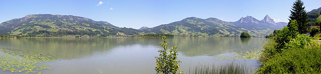
Unterägeri is a picturesque municipality located in the Canton of Zug, Switzerland, surrounded by stunning landscapes and offering fantastic opportunities for hiking enthusiasts. Here are some highlights and points of interest for hiking in and around Unterägeri:
Scenic Trails
-
Zugerberg Mountain: The trails leading up to Zugerberg offer breathtaking views of Lake Zug and the surrounding mountains. You can find several well-marked paths suitable for different skill levels.
-
Ägerital Valley: This area features beautiful lake views and rolling hills, with trails that wind alongside the Ägerisee. It’s a great spot for both leisurely hikes and more challenging excursions.
-
Hiking to the Iron Bridge (Eisenbrücke): This relatively easy hike takes you to a historic iron bridge with scenic vistas and opportunities for photography.
Nature and Wildlife
- Diverse Flora and Fauna: The region around Unterägeri is rich in biodiversity. You may encounter various plant species and wildlife, including deer and various bird species.
Family-Friendly Options
- There are many easy and moderate trails that are suitable for families with children, making it an ideal destination for a family outing.
Accessibility
- The region is well-connected by public transport, and many trailheads can be easily accessed by bus or train from Unterägeri.
Local Tips
- Weather Considerations: Always check the weather forecast and be prepared for sudden changes in mountain weather.
- Proper Gear: Make sure to wear appropriate hiking shoes and carry enough water and snacks, as some trails can be longer and more arduous than they appear.
Events and Guided Hikes
- Look out for local guided hikes or special events, which are often organized by tourism boards or local hiking clubs. This can be a great way to explore the area with knowledgeable guides.
With its stunning scenery and varied hiking options, Unterägeri offers something for everyone, whether you’re looking for a leisurely stroll or an adventurous hike. Before you go, always ensure you have a map or a reliable GPS device, and enjoy the natural beauty that this Swiss region has to offer!
- Страна:

- Почтовый код: 6314
- Телефонный код: 041
- Код автомобильного номера: ZG
- Координаты: 47° 7' 14" N, 8° 34' 40" E


- GPS треки (wikiloc): [Ссылка]
- Высота над уровнем моря: 763 м m
- Площадь: 26.7 кв.км
- Население: 8689
- Веб сайт: http://www.unteraegeri.ch
- Википедия русская: wiki(ru)
- Википедия английская: wiki(en)
- Википедия национальная: wiki(de)
- Хранилище Wikidata: Wikidata: Q65658
- Галерея изображений в википедии: [Ссылка]
- Катеория в википедии: [Ссылка]
- код Freebase: [/m/0b4ctb]
- код GeoNames: Альт: [7287371]
- код VIAF: Альт: [246951029]
- ID отношения в OpenStreetMap: [1683149]
- код темы Quora: [Unterägeri]
- идентификатор HDS: [795]
- код швейцарского муниципалитета: [1709]
Граничит с регионами:

Бар
- город и коммуна в Швейцарии, в кантоне Цуг
Hiking in Бар
Baar, located in the canton of Zug in Switzerland, offers a variety of hiking opportunities that allow you to enjoy the stunning natural landscapes of the region. The area is characterized by rolling hills, lush forests, and beautiful views of the surrounding mountains and Lake Zug....
- Страна:
- Почтовый код: 6340
- Телефонный код: 041
- Код автомобильного номера: ZG
- Координаты: 47° 11' 44" N, 8° 31' 35" E
- GPS треки (wikiloc): [Ссылка]
- Высота над уровнем моря: 443 м m
- Площадь: 24.83 кв.км
- Население: 24322
- Веб сайт: [Ссылка]

Оберегери
- коммуна в Швейцарии
Hiking in Оберегери
Oberägeri, located in the Canton of Zug in Switzerland, is a beautiful destination for hiking enthusiasts. Nestled between the Ägeri lake and the surrounding hills, it offers a variety of trails that cater to different skill levels and provide stunning views of the Swiss landscape....
- Страна:
- Почтовый код: 6315
- Телефонный код: 041
- Код автомобильного номера: ZG
- Координаты: 47° 8' 9" N, 8° 36' 49" E
- GPS треки (wikiloc): [Ссылка]
- Высота над уровнем моря: 737 м m
- Площадь: 36.2 кв.км
- Население: 6059
- Веб сайт: [Ссылка]


Заттель
- коммуна в Швейцарии
Hiking in Заттель
Sattel, located in the canton of Schwyz, is a beautiful hiking destination in Switzerland, known for its stunning landscapes and a range of outdoor activities. Situated between Lake Zug and Lake Lauerz, Sattel offers breathtaking views of the surrounding mountains and valleys....
- Страна:
- Почтовый код: 6417
- Телефонный код: 041
- Код автомобильного номера: SZ
- Координаты: 47° 4' 48" N, 8° 37' 55" E
- GPS треки (wikiloc): [Ссылка]
- Высота над уровнем моря: 780 м m
- Площадь: 17.3 кв.км
- Население: 1946
- Веб сайт: [Ссылка]

Менцинген
Hiking in Менцинген
Menzingen is a charming municipality located in the Canton of Zug, Switzerland. It is surrounded by beautiful nature and rolling hills, making it an ideal location for hiking enthusiasts. Here are some highlights and tips for hiking in Menzingen:...
- Страна:
- Почтовый код: 6313
- Телефонный код: 041
- Код автомобильного номера: ZG
- Координаты: 47° 10' 12" N, 8° 36' 11" E
- GPS треки (wikiloc): [Ссылка]
- Высота над уровнем моря: 801 м m
- Площадь: 27.50 кв.км
- Население: 4499
- Веб сайт: [Ссылка]

Вальхвиль
- коммуна в Швейцарии
Hiking in Вальхвиль
Walchwil is a picturesque village located in the Canton of Zug in Switzerland, situated on the shores of Lake Zug. It offers a range of hiking opportunities, making it an excellent destination for both casual walkers and seasoned hikers. Here are some highlights and tips for hiking in and around Walchwil:...
- Страна:
- Почтовый код: 6318
- Телефонный код: 041
- Код автомобильного номера: ZG
- Координаты: 47° 6' 31" N, 8° 31' 57" E
- GPS треки (wikiloc): [Ссылка]
- Высота над уровнем моря: 942 м m
- Площадь: 15.9 кв.км
- Население: 3617
- Веб сайт: [Ссылка]

Штайнерберг
- коммуна в Швейцарии
Hiking in Штайнерберг
Steinerberg, located in the beautiful region of Switzerland, offers an array of hiking opportunities for both beginners and experienced hikers. The area is renowned for its breathtaking landscapes, serene nature, and well-maintained trails....
- Страна:
- Почтовый код: 6416
- Телефонный код: 041
- Код автомобильного номера: SZ
- Координаты: 47° 4' 3" N, 8° 34' 52" E
- GPS треки (wikiloc): [Ссылка]
- Высота над уровнем моря: 937 м m
- Площадь: 6.9 кв.км
- Население: 954
- Веб сайт: [Ссылка]


Цуг
Hiking in Цуг
Hiking in Zug, Switzerland, offers a wonderful blend of scenic beauty, varied terrain, and accessible trails, making it an ideal destination for both casual walkers and experienced hikers. Here are some key highlights about hiking in the area:...
- Страна:
- Почтовый код: 6317; 6305; 6300; 6310; 6300–6305
- Телефонный код: 041
- Код автомобильного номера: ZG
- Координаты: 47° 10' 9" N, 8° 30' 59" E
- GPS треки (wikiloc): [Ссылка]
- Высота над уровнем моря: 611 м m
- Площадь: 21.61 кв.км
- Население: 30205
- Веб сайт: [Ссылка]