L'Hermitière (L'Hermitière)

- former commune in Orne, France
- Country:

- Postal Code: 61260
- Coordinates: 48° 16' 55" N, 0° 38' 41" E


- GPS tracks (wikiloc): [Link]
- Area: 8.34 sq km
- Population: 251
- Wikipedia en: wiki(en)
- Wikipedia: wiki(fr)
- Wikidata storage: Wikidata: Q1155623
- Wikipedia Commons Category: [Link]
- Freebase ID: [/m/03qgrb7]
- Freebase ID: [/m/03qgrb7]
- GeoNames ID: Alt: [6615036]
- GeoNames ID: Alt: [6615036]
- BnF ID: [15268136n]
- BnF ID: [15268136n]
- VIAF ID: Alt: [240066177]
- VIAF ID: Alt: [240066177]
- INSEE municipality code: 61204
- INSEE municipality code: 61204
Shares border with regions:


Gémages
- former commune in Orne, France
- Country:
- Postal Code: 61130
- Coordinates: 48° 17' 39" N, 0° 36' 56" E
- GPS tracks (wikiloc): [Link]
- Area: 6.47 sq km
- Population: 121

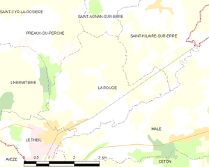
La Rouge
- former commune in Orne, France
- Country:
- Postal Code: 61260
- Coordinates: 48° 17' 11" N, 0° 42' 25" E
- GPS tracks (wikiloc): [Link]
- Area: 11.74 sq km
- Population: 732


Saint-Cyr-la-Rosière
- commune in Orne, France
- Country:
- Postal Code: 61130
- Coordinates: 48° 19' 50" N, 0° 38' 25" E
- GPS tracks (wikiloc): [Link]
- Area: 18.75 sq km
- Population: 240


Préaux-du-Perche
- former commune in Orne, France
- Country:
- Postal Code: 61340
- Coordinates: 48° 19' 48" N, 0° 42' 12" E
- GPS tracks (wikiloc): [Link]
- AboveSeaLevel: 123 м m
- Area: 23.52 sq km
- Population: 546
- Web site: [Link]