Les Églises-d'Argenteuil (Les Églises-d'Argenteuil)

- commune in Charente-Maritime, France
- Country:

- Postal Code: 17400
- Coordinates: 45° 58' 25" N, 0° 25' 58" E


- GPS tracks (wikiloc): [Link]
- Area: 14.29 sq km
- Population: 522
- Wikipedia en: wiki(en)
- Wikipedia: wiki(fr)
- Wikidata storage: Wikidata: Q1095490
- Wikipedia Commons Category: [Link]
- Freebase ID: [/m/03mch3z]
- GeoNames ID: Alt: [6455629]
- SIREN number: [211701503]
- BnF ID: [152490126]
- INSEE municipality code: 17150
Shares border with regions:


Antezant-la-Chapelle
- commune in Charente-Maritime, France
- Country:
- Postal Code: 17400
- Coordinates: 45° 58' 57" N, 0° 27' 23" E
- GPS tracks (wikiloc): [Link]
- AboveSeaLevel: 30 м m
- Area: 18.63 sq km
- Population: 356

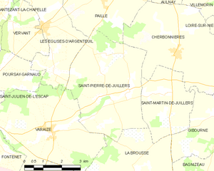
Saint-Pierre-de-Juillers
- commune in Charente-Maritime, France
- Country:
- Postal Code: 17400
- Coordinates: 45° 56' 23" N, 0° 23' 27" E
- GPS tracks (wikiloc): [Link]
- Area: 17.59 sq km
- Population: 367
- Web site: [Link]

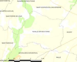
Nuaillé-sur-Boutonne
- commune in Charente-Maritime, France
- Country:
- Postal Code: 17470
- Coordinates: 46° 0' 49" N, 0° 26' 5" E
- GPS tracks (wikiloc): [Link]
- Area: 10.48 sq km
- Population: 210


Vervant
- commune in Charente-Maritime, France
- Country:
- Postal Code: 17400
- Coordinates: 45° 58' 25" N, 0° 27' 16" E
- GPS tracks (wikiloc): [Link]
- Area: 5.62 sq km
- Population: 241


Poursay-Garnaud
- commune in Charente-Maritime, France
- Country:
- Postal Code: 17400
- Coordinates: 45° 57' 10" N, 0° 27' 38" E
- GPS tracks (wikiloc): [Link]
- Area: 5.22 sq km
- Population: 318

Paillé
- commune in Charente-Maritime, France
- Country:
- Postal Code: 17470
- Coordinates: 45° 59' 22" N, 0° 23' 36" E
- GPS tracks (wikiloc): [Link]
- Area: 12.44 sq km
- Population: 320

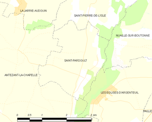
Saint-Pardoult
- commune in Charente-Maritime, France
- Country:
- Postal Code: 17400
- Coordinates: 46° 0' 0" N, 0° 27' 0" E
- GPS tracks (wikiloc): [Link]
- Area: 5.6 sq km
- Population: 233
- Web site: [Link]


Varaize
- commune in Charente-Maritime, France
- Country:
- Postal Code: 17400
- Coordinates: 45° 55' 21" N, 0° 25' 21" E
- GPS tracks (wikiloc): [Link]
- Area: 20.48 sq km
- Population: 559
- Web site: [Link]