Parigné-l'Évêque (Parigné-l'Évêque)

- commune in Sarthe, France
- Country:

- Postal Code: 72250
- Coordinates: 47° 56' 11" N, 0° 21' 52" E


- GPS tracks (wikiloc): [Link]
- Area: 63.4 sq km
- Population: 4913
- Web site: http://www.parigneleveque.fr
- Wikipedia en: wiki(en)
- Wikipedia: wiki(fr)
- Wikidata storage: Wikidata: Q1226398
- Wikipedia Commons Category: [Link]
- Freebase ID: [/m/03qj018]
- GeoNames ID: Alt: [6442653]
- SIREN number: [217202316]
- VIAF ID: Alt: [237471405]
- INSEE municipality code: 72231
Shares border with regions:

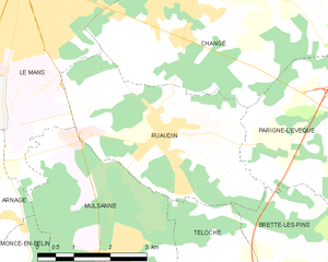
Ruaudin
- commune in Sarthe, France
- Country:
- Postal Code: 72230
- Coordinates: 47° 56' 41" N, 0° 15' 59" E
- GPS tracks (wikiloc): [Link]
- Area: 13.78 sq km
- Population: 3403
- Web site: [Link]

Saint-Mars-d'Outillé
- commune in Sarthe, France
- Country:
- Postal Code: 72220
- Coordinates: 47° 52' 15" N, 0° 19' 56" E
- GPS tracks (wikiloc): [Link]
- Area: 38.04 sq km
- Population: 2389
- Web site: [Link]


Brette-les-Pins
- commune in Sarthe, France
- Country:
- Postal Code: 72250
- Coordinates: 47° 54' 40" N, 0° 20' 13" E
- GPS tracks (wikiloc): [Link]
- Area: 14.51 sq km
- Population: 2148
- Web site: [Link]


Ardenay-sur-Mérize
- commune in Sarthe, France
- Country:
- Postal Code: 72370
- Coordinates: 47° 59' 42" N, 0° 25' 29" E
- GPS tracks (wikiloc): [Link]
- Area: 11.67 sq km
- Population: 480
- Web site: [Link]


Challes, Sarthe
- commune in Sarthe, France
- Country:
- Postal Code: 72250
- Coordinates: 47° 55' 52" N, 0° 24' 51" E
- GPS tracks (wikiloc): [Link]
- Area: 25.83 sq km
- Population: 1229
- Web site: [Link]


Saint-Mars-la-Brière
- commune in Sarthe, France
- Country:
- Postal Code: 72470
- Coordinates: 48° 1' 45" N, 0° 22' 22" E
- GPS tracks (wikiloc): [Link]
- Area: 34.69 sq km
- Population: 2665

Le Grand-Lucé
- commune in Sarthe, France
- Country:
- Postal Code: 72150
- Coordinates: 47° 51' 54" N, 0° 28' 10" E
- GPS tracks (wikiloc): [Link]
- Area: 27.26 sq km
- Population: 1917


Changé, Sarthe
- commune in Sarthe, France
- Country:
- Postal Code: 72560
- Coordinates: 47° 59' 16" N, 0° 16' 55" E
- GPS tracks (wikiloc): [Link]
- Area: 35.06 sq km
- Population: 6446
- Web site: [Link]