
Villeneuve-d'Ascq (Villeneuve-d'Ascq)

- commune in Nord, France
- Country:

- Postal Code: 59650; 59493; 59491
- Coordinates: 50° 37' 22" N, 3° 8' 39" E


- GPS tracks (wikiloc): [Link]
- AboveSeaLevel: 29 м m
- Area: 27.46 sq km
- Population: 61920
- Web site: http://www.villeneuvedascq.fr
- Wikipedia en: wiki(en)
- Wikipedia: wiki(fr)
- Wikidata storage: Wikidata: Q43295
- Wikipedia Commons Gallery: [Link]
- Wikipedia Commons Category: [Link]
- Wikipedia Commons Maps Category: [Link]
- Freebase ID: [/m/02p3gb]
- Freebase ID: [/m/02p3gb]
- Freebase ID: [/m/02p3gb]
- SIREN number: [215900093]
- SIREN number: [215900093]
- SIREN number: [215900093]
- BnF ID: [153473659]
- BnF ID: [153473659]
- BnF ID: [153473659]
- VIAF ID: Alt: [146632006]
- VIAF ID: Alt: [146632006]
- VIAF ID: Alt: [146632006]
- GND ID: Alt: [4119440-8]
- GND ID: Alt: [4119440-8]
- GND ID: Alt: [4119440-8]
- archINFORM location ID: [5002]
- archINFORM location ID: [5002]
- archINFORM location ID: [5002]
- Library of Congress authority ID: Alt: [n84128423]
- Library of Congress authority ID: Alt: [n84128423]
- Library of Congress authority ID: Alt: [n84128423]
- PACTOLS thesaurus ID: [pcrtwhMzOMjTFW]
- PACTOLS thesaurus ID: [pcrtwhMzOMjTFW]
- PACTOLS thesaurus ID: [pcrtwhMzOMjTFW]
- MusicBrainz area ID: [8d4e96c1-bfa1-4dec-8d50-ceaa6abe8e2f]
- MusicBrainz area ID: [8d4e96c1-bfa1-4dec-8d50-ceaa6abe8e2f]
- MusicBrainz area ID: [8d4e96c1-bfa1-4dec-8d50-ceaa6abe8e2f]
- Quora topic ID: [Villeneuve-dAscq]
- Quora topic ID: [Villeneuve-dAscq]
- Quora topic ID: [Villeneuve-dAscq]
- Gran Enciclopèdia Catalana ID: [0071116]
- Gran Enciclopèdia Catalana ID: [0071116]
- Gran Enciclopèdia Catalana ID: [0071116]
- ISNI: Alt: [0000 0001 2154 2747]
- ISNI: Alt: [0000 0001 2154 2747]
- ISNI: Alt: [0000 0001 2154 2747]
- NKCR AUT ID: [ge973672]
- NKCR AUT ID: [ge973672]
- NKCR AUT ID: [ge973672]
- INSEE municipality code: 59009
- INSEE municipality code: 59009
- INSEE municipality code: 59009
Includes regions:
Annappes
- human settlement in France
- Country:
- Coordinates: 50° 37' 37" N, 3° 8' 59" E
- GPS tracks (wikiloc): [Link]
Flers Breucq
- human settlement in France
- Country:
- Coordinates: 50° 39' 47" N, 3° 8' 19" E
- GPS tracks (wikiloc): [Link]

Haute Borne
- Country:
- Coordinates: 50° 36' 12" N, 3° 9' 12" E
- GPS tracks (wikiloc): [Link]
Brigode (quartier)
- human settlement in France
- Country:
- Coordinates: 50° 37' 59" N, 3° 9' 56" E
- GPS tracks (wikiloc): [Link]
château
- human settlement in France
- Country:
- Coordinates: 50° 38' 9" N, 3° 7' 58" E
- GPS tracks (wikiloc): [Link]


Cousinerie
- human settlement in France
- Country:
- Coordinates: 50° 38' 37" N, 3° 9' 10" E
- GPS tracks (wikiloc): [Link]

Flers Bourg
- human settlement in France
- Country:
- Coordinates: 50° 38' 10" N, 3° 7' 46" E
- GPS tracks (wikiloc): [Link]
hôtel de Ville
- human settlement in France
- Country:
- Coordinates: 50° 37' 9" N, 3° 7' 53" E
- GPS tracks (wikiloc): [Link]
Pont-de-Bois
- human settlement in France
- Country:
- Coordinates: 50° 37' 30" N, 3° 7' 42" E
- GPS tracks (wikiloc): [Link]
Poste
- area of the town of Villeneuve d'Ascq, France
- Country:
- Coordinates: 50° 37' 30" N, 3° 8' 31" E
- GPS tracks (wikiloc): [Link]
Prés
- human settlement in France
- Country:
- Coordinates: 50° 39' 0" N, 3° 7' 35" E
- GPS tracks (wikiloc): [Link]
Recueil
- human settlement in France
- Country:
- Coordinates: 50° 39' 28" N, 3° 9' 11" E
- GPS tracks (wikiloc): [Link]
Résidence
- human settlement in France
- Country:
- Coordinates: 50° 37' 18" N, 3° 8' 34" E
- GPS tracks (wikiloc): [Link]
Sart-Babylone
- human settlement in France
- Country:
- Coordinates: 50° 39' 24" N, 3° 7' 55" E
- GPS tracks (wikiloc): [Link]
Triolo
- human settlement in France
- Country:
- Coordinates: 50° 37' 0" N, 3° 8' 28" E
- GPS tracks (wikiloc): [Link]
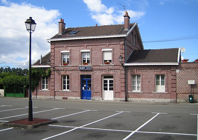
Ascq
- human settlement
- Country:
- Coordinates: 50° 37' 10" N, 3° 9' 35" E
- GPS tracks (wikiloc): [Link]
Shares border with regions:


Hem
- commune in Nord, France
- Country:
- Postal Code: 59510
- Coordinates: 50° 39' 19" N, 3° 11' 16" E
- GPS tracks (wikiloc): [Link]
- Area: 9.65 sq km
- Population: 19010
- Web site: [Link]


Forest-sur-Marque
- commune in Nord, France
- Country:
- Postal Code: 59510
- Coordinates: 50° 38' 3" N, 3° 11' 21" E
- GPS tracks (wikiloc): [Link]
- Area: 1.05 sq km
- Population: 1437
- Web site: [Link]


Willems
- commune in Nord, France
- Country:
- Postal Code: 59780
- Coordinates: 50° 37' 55" N, 3° 14' 18" E
- GPS tracks (wikiloc): [Link]
- Area: 5.8 sq km
- Population: 3025


Croix
- commune in Nord, France
- Country:
- Postal Code: 59170
- Coordinates: 50° 40' 29" N, 3° 9' 14" E
- GPS tracks (wikiloc): [Link]
- Area: 4.44 sq km
- Population: 21239
- Web site: [Link]

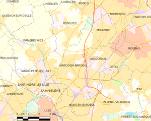
Marcq-en-Barœul
- commune in Nord, France
- Country:
- Postal Code: 59700
- Coordinates: 50° 40' 13" N, 3° 5' 47" E
- GPS tracks (wikiloc): [Link]
- AboveSeaLevel: 21 м m
- Area: 14.04 sq km
- Population: 39298
- Web site: [Link]


Tressin
- commune in Nord, France
- Country:
- Postal Code: 59152
- Coordinates: 50° 37' 11" N, 3° 11' 39" E
- GPS tracks (wikiloc): [Link]
- Area: 1.89 sq km
- Population: 1415
- Web site: [Link]


Sailly-lez-Lannoy
- commune in Nord, France
- Country:
- Postal Code: 59390
- Coordinates: 50° 38' 49" N, 3° 13' 25" E
- GPS tracks (wikiloc): [Link]
- AboveSeaLevel: 35 м m
- Area: 4.43 sq km
- Population: 1696
- Web site: [Link]


Sainghin-en-Mélantois
- commune in Nord, France
- Country:
- Postal Code: 59262
- Coordinates: 50° 35' 13" N, 3° 10' 3" E
- GPS tracks (wikiloc): [Link]
- Area: 10.48 sq km
- Population: 2615
- Web site: [Link]

Lille
- commune in Nord, France
- Country:
- Postal Code: 59800; 59777; 59260; 59160; 59000
- Coordinates: 50° 37' 55" N, 3° 3' 27" E
- GPS tracks (wikiloc): [Link]
- AboveSeaLevel: 46 м m
- Area: 34.83 sq km
- Population: 232741
- Web site: [Link]


Lezennes
- commune in Nord, France
- Country:
- Postal Code: 59260
- Coordinates: 50° 36' 52" N, 3° 6' 48" E
- GPS tracks (wikiloc): [Link]
- Area: 2.14 sq km
- Population: 3117


Wasquehal
- commune in Nord, France
- Country:
- Postal Code: 59290
- Coordinates: 50° 40' 7" N, 3° 7' 48" E
- GPS tracks (wikiloc): [Link]
- Area: 6.86 sq km
- Population: 20963
- Web site: [Link]


Mons-en-Barœul
- commune in Nord, France
- Country:
- Postal Code: 59370
- Coordinates: 50° 38' 31" N, 3° 6' 28" E
- GPS tracks (wikiloc): [Link]
- AboveSeaLevel: 80 м m
- Area: 2.88 sq km
- Population: 20993
- Web site: [Link]


Anstaing
- commune in Nord, France
- Country:
- Postal Code: 59152
- Coordinates: 50° 36' 19" N, 3° 11' 27" E
- GPS tracks (wikiloc): [Link]
- Area: 2.3 sq km
- Population: 1404
- Web site: [Link]