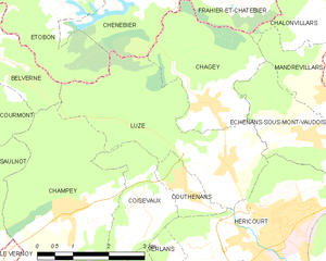
Эшнан-су-Мон-Водуа (Échenans-sous-Mont-Vaudois, Échenans-sous-Mont-Vaudois)

- коммуна во Франции
 Hiking in Эшнан-су-Мон-Водуа
Échenans-sous-Mont-Vaudois, located in the Bourgogne-Franche-Comté region of France, offers a serene and scenic environment for hiking enthusiasts. While it may not be one of the most prominent hiking destinations, it provides a peaceful escape into nature, particularly for those who enjoy exploring less crowded trails.
Hiking Features:
-
Natural Beauty: The area is characterized by a mix of forests, rolling hills, and picturesque landscapes. This makes it a perfect spot for leisurely hikes where you can enjoy the tranquility of the French countryside.
-
Trails: While specific marked trails may not be extensively detailed in the area, hikers can explore paths that wind through the forests and farmlands surrounding the village. Local maps might show potential routes that vary in difficulty.
-
Flora and Fauna: The region is home to diverse wildlife and plant species, offering excellent opportunities for nature observation. Bird watchers and wildlife enthusiasts may find plenty to appreciate.
-
Accessibility: Échenans-sous-Mont-Vaudois is accessible and can be a perfect starting point for longer hikes into the neighboring areas or through the foothills of the Jura Mountains.
-
Local Tips: It’s a good idea to stop by local tourist information centers for maps and information about any recently maintained trails or signs that may enhance your hiking experience.
-
Best Time to Visit: Spring and early fall are often the best times for hiking in this region due to mild weather and vibrant foliage. Summers can be warm, while winters may bring snow, which can either limit access or require additional equipment for winter hiking.
Safety & Preparedness:
- Always carry enough water, snacks, and a first aid kit.
- Wear appropriate hiking boots and clothing for varying weather conditions.
- Make sure to inform someone of your hiking plans, especially if you are venturing into less traversed areas.
While Échenans-sous-Mont-Vaudois may not be a well-known hiking destination, it offers a unique chance to enjoy rural France and its natural beauty away from the bustling tourist paths. Happy hiking!
- Страна:

- Почтовый код: 70400
- Координаты: 47° 36' 10" N, 6° 46' 18" E


- GPS треки (wikiloc): [Ссылка]
- Высота над уровнем моря: 381 м m
- Площадь: 5.44 кв.км
- Население: 499
- Википедия русская: wiki(ru)
- Википедия английская: wiki(en)
- Википедия национальная: wiki(fr)
- Хранилище Wikidata: Wikidata: Q273359
- Катеория в википедии: [Ссылка]
- код Freebase: [/m/03nvt3k]
- код GeoNames: Альт: [3020514]
- номер SIREN: [217002062]
- код BNF: [15272600s]
- код муниципалитета INSEE: 70206
Граничит с регионами:

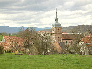
Люз
- коммуна во Франции
Hiking in Люз
Luze is a charming commune located in the Haute-Saône department in eastern France, known for its picturesque landscapes and opportunities for outdoor activities, including hiking. The area is characterized by rolling hills, lush forests, and scenic countryside, making it a great destination for hiking enthusiasts....
- Страна:
- Почтовый код: 70400
- Координаты: 47° 35' 49" N, 6° 44' 23" E
- GPS треки (wikiloc): [Ссылка]
- Площадь: 10.69 кв.км
- Население: 711

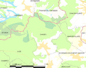
Шаже
- коммуна во Франции
Hiking in Шаже
Chagey, located in the Haute-Saône department of France, offers a unique hiking experience characterized by its picturesque landscapes and natural beauty. While it is a small village, the surrounding area provides various trails that showcase the region's charming countryside, including rolling hills, forests, and rivers....
- Страна:
- Почтовый код: 70400
- Координаты: 47° 36' 43" N, 6° 44' 6" E
- GPS треки (wikiloc): [Ссылка]
- Площадь: 6.99 кв.км
- Население: 651


Banvillars
- коммуна во Франции
Hiking in Banvillars
Banvillars is a small village located in the Bourgogne-Franche-Comté region of France, known for its picturesque countryside and natural beauty. While it may not be as famous as some of the larger hiking destinations, it offers a unique and charming experience for hikers looking to explore the serene landscapes of eastern France....
- Страна:
- Почтовый код: 90800
- Координаты: 47° 35' 32" N, 6° 48' 53" E
- GPS треки (wikiloc): [Ссылка]
- Площадь: 4.67 кв.км
- Население: 283
- Веб сайт: [Ссылка]


Мандревиллар
- коммуна во Франции
Hiking in Мандревиллар
Mandrevillars is a charming location in France, nestled in the Franche-Comté region. While not as widely recognized as some major hiking destinations, it offers beautiful landscapes, picturesque views, and opportunities for outdoor activities. Here’s what you can expect when hiking in and around Mandrevillars:...
- Страна:
- Почтовый код: 70400
- Координаты: 47° 36' 47" N, 6° 46' 40" E
- GPS треки (wikiloc): [Ссылка]
- Площадь: 3.03 кв.км
- Население: 234

Buc
- коммуна во Франции
Hiking in Buc
Buc, located in the Territoire de Belfort department in the Bourgogne-Franche-Comté region of France, offers varying hiking opportunities that showcase the beautiful natural landscapes of the area. While Buc itself may not be a well-known hiking destination, its proximity to the Vosges Mountains and the Ballons des Vosges Regional Natural Park provides many trails ideal for hiking enthusiasts....
- Страна:
- Почтовый код: 90800
- Координаты: 47° 36' 53" N, 6° 47' 7" E
- GPS треки (wikiloc): [Ссылка]
- Площадь: 2.44 кв.км
- Население: 294

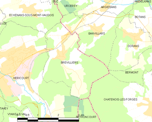
Бревилье
- коммуна во Франции
Hiking in Бревилье
Brevilliers is a small village located in the Doubs department of the Bourgogne-Franche-Comté region in eastern France. While it is not a well-known hiking destination, the surrounding area offers beautiful landscapes and trails that can be explored by hiking enthusiasts....
- Страна:
- Почтовый код: 70400
- Координаты: 47° 34' 54" N, 6° 47' 32" E
- GPS треки (wikiloc): [Ссылка]
- Площадь: 6.47 кв.км
- Население: 619


Urcerey
- коммуна во Франции
Hiking in Urcerey
Urcerey is not a widely recognized hiking destination, so it might refer to a specific area with local interest or a less-known name. However, if you meant a popular hiking area or trail with a name similar to Urcerey, please clarify....
- Страна:
- Почтовый код: 90800
- Координаты: 47° 36' 29" N, 6° 48' 33" E
- GPS треки (wikiloc): [Ссылка]
- Площадь: 3.39 кв.км
- Население: 215