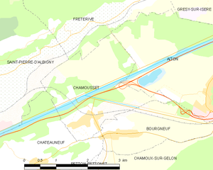
Этон (Aiton, Savoie, Aiton)

- коммуна во Франции
 Hiking in Этон
Aiton, located in the Savoie department of the Auvergne-Rhône-Alpes region in southeastern France, offers a variety of hiking opportunities in a beautiful natural setting. Here’s an overview of what you can expect:
Scenery and Landscape
Aiton is surrounded by stunning landscapes that include rolling hills, alpine meadows, and views of the nearby mountains, particularly the Chartreuse and Bauges ranges. The region boasts a mix of flora and fauna, making for a rich hiking experience.
Hiking Trails
While Aiton may not be as well-known as some other hiking destinations in the Alps, it offers access to several trails suitable for all levels of hikers. Some popular hiking routes include:
-
Les Chemins de la Chartreuse: This network of trails in the nearby Chartreuse mountains is ideal for exploring the rich natural heritage of the area. Routes vary in difficulty and distance.
-
Mont Granier: For those seeking a challenge, hiking to Mont Granier provides stunning panoramic views. The ascent can be steep, so be prepared with proper gear and fitness.
-
Local Nature Trails: Within the valley itself, you can find shorter, well-marked trails, perfect for families and those looking for leisurely strolls.
Tips for Hiking in Aiton
- Seasonal Considerations: Spring and fall are excellent times for hiking, with mild temperatures and beautiful scenery. Summer can be warm, while winter may bring snow, so plan accordingly.
- Gear: Wear appropriate footwear and bring layers, as weather can change quickly in the mountains. Don't forget water and snacks!
- Maps and Navigation: While many trails are marked, carrying a map or GPS device is recommended. Mobile reception may be limited in certain areas.
- Respect Nature: Stay on marked trails, pack out what you pack in, and respect local wildlife.
Local Attractions
After a day of hiking, consider exploring Aiton's local culture and history. The village itself has traditional architecture and charming streets perfect for a leisurely walk. Additionally, nearby towns like Chambéry offer historical sites and amenities for hikers.
In summary, Aiton offers a delightful mix of hiking opportunities suitable for various skill levels, surrounded by beautiful mountain scenery. Enjoy your hike!
- Страна:

- Почтовый код: 73220
- Координаты: 45° 33' 40" N, 6° 15' 31" E


- GPS треки (wikiloc): [Ссылка]
- Площадь: 16.29 кв.км
- Население: 1706
- Википедия английская: wiki(en)
- Википедия национальная: wiki(fr)
- Хранилище Wikidata: Wikidata: Q410809
- Катеория в википедии: [Ссылка]
- код Freebase: [/m/03cb_y7]
- код GeoNames: Альт: [6452509]
- номер SIREN: [217300078]
- код BNF: [152739434]
- код тезауруса PACTOLS: [pcrtpDycB9vD3p]
- код муниципалитета INSEE: 73007
Граничит с регионами:


Grésy-sur-Isère
- коммуна во Франции
Hiking in Grésy-sur-Isère
Grésy-sur-Isère is a charming town located in the Savoie department of the Auvergne-Rhône-Alpes region in southeastern France. Surrounded by the stunning landscapes of the French Alps, it offers several hiking opportunities that cater to different skill levels and preferences....
- Страна:
- Почтовый код: 73460
- Координаты: 45° 36' 4" N, 6° 15' 13" E
- GPS треки (wikiloc): [Ссылка]
- Площадь: 9.02 кв.км
- Население: 1242
Bonvillard
- коммуна во Франции
Hiking in Bonvillard
Bonvillard, a charming village located in the French Alps, offers beautiful hiking opportunities that showcase the region's stunning landscapes. While it may not be as well-known as larger hiking destinations, it provides a serene experience for those looking to explore nature away from the crowds. Here are some key highlights about hiking in Bonvillard:...
- Страна:
- Почтовый код: 73460
- Координаты: 45° 35' 12" N, 6° 18' 19" E
- GPS треки (wikiloc): [Ссылка]
- Площадь: 17.1 кв.км
- Население: 355

Chamousset
- коммуна во Франции
Hiking in Chamousset
Chamousset, located in the Savoie region of the French Alps, is a lesser-known yet beautiful area for hiking enthusiasts. This picturesque village is surrounded by stunning alpine scenery, making it an excellent starting point for a variety of hiking trails that cater to different skill levels....
- Страна:
- Почтовый код: 73390
- Координаты: 45° 33' 21" N, 6° 11' 57" E
- GPS треки (wikiloc): [Ссылка]
- Площадь: 6.31 кв.км
- Население: 579
Bonvillaret
- коммуна во Франции
Hiking in Bonvillaret
Bonvillaret is a picturesque area located in the French Alps, particularly known for its stunning landscapes and a variety of hiking opportunities. Though it's a lesser-known location compared to more popular destinations like Chamonix or Annecy, it offers a unique experience for hikers looking for tranquility and natural beauty....
- Страна:
- Почтовый код: 73220
- Координаты: 45° 33' 45" N, 6° 18' 2" E
- GPS треки (wikiloc): [Ссылка]
- Площадь: 8.88 кв.км
- Население: 138


Fréterive
- коммуна во Франции
Hiking in Fréterive
Fréterive is a lesser-known but beautiful area that attracts hikers with its scenic landscapes, diverse trails, and tranquil nature. While specific information about Fréterive may not be extensively documented, there are several general aspects to consider when hiking in this region or similar mountainous areas....
- Страна:
- Почтовый код: 73250
- Координаты: 45° 35' 4" N, 6° 12' 37" E
- GPS треки (wikiloc): [Ссылка]
- Площадь: 11.01 кв.км
- Население: 549


Montailleur
- коммуна во Франции
Hiking in Montailleur
Montailleur is a charming commune located in the Savoie department in the Auvergne-Rhône-Alpes region of southeastern France. It's situated in the foothills of the French Alps and offers a variety of hiking opportunities for outdoor enthusiasts....
- Страна:
- Почтовый код: 73460
- Координаты: 45° 37' 3" N, 6° 16' 45" E
- GPS треки (wikiloc): [Ссылка]
- Площадь: 15.3 кв.км
- Население: 681


Sainte-Hélène-sur-Isère
- коммуна во Франции
Hiking in Sainte-Hélène-sur-Isère
Sainte-Hélène-sur-Isère is a charming commune located in the Auvergne-Rhône-Alpes region of France, nestled in the Isère department. Its picturesque surroundings make it an excellent destination for hiking enthusiasts. Here’s what you can expect when hiking in and around this lovely area:...
- Страна:
- Почтовый код: 73460
- Координаты: 45° 36' 50" N, 6° 19' 15" E
- GPS треки (wikiloc): [Ссылка]
- Площадь: 14.43 кв.км
- Население: 1185
- Веб сайт: [Ссылка]


Bourgneuf, Savoie
Hiking in Bourgneuf, Savoie
Bourgneuf, located in the Savoie region of the French Alps, offers a variety of hiking opportunities for all levels of experience. The stunning alpine landscapes, with their breathtaking views, lush valleys, and diverse flora and fauna, make it a wonderful destination for outdoor enthusiasts....
- Страна:
- Почтовый код: 73390
- Координаты: 45° 33' 8" N, 6° 12' 41" E
- GPS треки (wikiloc): [Ссылка]
- Площадь: 6.48 кв.км
- Население: 685