Bourgneuf, Savoie (Bourgneuf)

 Hiking in Bourgneuf, Savoie
Bourgneuf, located in the Savoie region of the French Alps, offers a variety of hiking opportunities for all levels of experience. The stunning alpine landscapes, with their breathtaking views, lush valleys, and diverse flora and fauna, make it a wonderful destination for outdoor enthusiasts.
Key Points for Hiking in Bourgneuf:
-
Trails: There are numerous well-marked trails ranging from easy strolls to challenging hikes. Some popular trails may lead you through scenic forests, past alpine meadows, and up to viewpoints overlooking the surrounding mountains.
-
Scenic Views: Many hikes in the area provide spectacular views of the Mont Blanc massif, the Beaufortain, and other surrounding ranges, especially at higher elevations.
-
Wildlife: The region is home to a variety of wildlife, including chamois, marmots, and various bird species. Keep your eyes peeled for these creatures, especially in the quieter areas away from the main paths.
-
Seasons: Hiking is popular in spring through fall (around June to October). Each season offers a unique perspective on the landscape, with flowers blooming in spring and the fall colors providing a stunning backdrop in autumn.
-
Safety: As with any hiking excursion, be sure to have the appropriate gear, including sturdy hiking boots, weather-appropriate clothing, and enough supplies such as water and snacks. It's also advisable to check the weather forecast and trail conditions before heading out.
-
Guided Tours: For those unfamiliar with the area, hiring a local guide can enhance the experience as they will know the best trails and can share knowledge about the local ecosystem and history.
-
Accommodation: There are various options for accommodation in Bourgneuf and nearby towns, ranging from cozy lodges to camping facilities for those looking to experience nature overnight.
-
Local Culture: Take the time to enjoy the local culture and cuisine after a long day of hiking. Savoie is known for its delicious cheeses and traditional dishes such as fondue and raclette.
Overall, Bourgneuf is a fantastic destination for hikers looking for a combination of natural beauty, adventure, and cultural experiences in the heart of the French Alps. Always remember to respect nature, stay on marked trails, and leave no trace. Happy hiking!
- Страна:

- Почтовый код: 73390
- Координаты: 45° 33' 8" N, 6° 12' 41" E


- GPS треки (wikiloc): [Ссылка]
- Площадь: 6.48 кв.км
- Население: 685
- Википедия английская: wiki(en)
- Википедия национальная: wiki(fr)
- Хранилище Wikidata: Wikidata: Q942791
- Катеория в википедии: [Ссылка]
- код Freebase: [/m/03npg9j]
- код GeoNames: Альт: [6450983]
- номер SIREN: [217300532]
- код BNF: [152739883]
- код муниципалитета INSEE: 73053
Граничит с регионами:

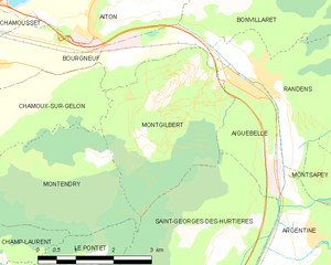
Montgilbert
- коммуна во Франции
Hiking in Montgilbert
Montgilbert is a charming destination located in the Savoie region of the French Alps, known for its stunning landscapes and outdoor activities, including hiking. Here are some key points about hiking in the area:...
- Страна:
- Почтовый код: 73220
- Координаты: 45° 32' 59" N, 6° 17' 5" E
- GPS треки (wikiloc): [Ссылка]
- Площадь: 9.53 кв.км
- Население: 121
Chamoux-sur-Gelon
- коммуна во Франции
Hiking in Chamoux-sur-Gelon
Chamoux-sur-Gelon is a charming village located in the French Alps, specifically in the Savoie region. It offers beautiful hiking opportunities for both beginners and experienced hikers....
- Страна:
- Почтовый код: 73390
- Координаты: 45° 31' 58" N, 6° 12' 56" E
- GPS треки (wikiloc): [Ссылка]
- Площадь: 10.63 кв.км
- Население: 924
- Веб сайт: [Ссылка]

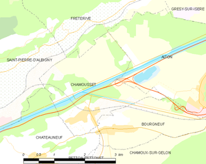
Chamousset
- коммуна во Франции
Hiking in Chamousset
Chamousset, located in the Savoie region of the French Alps, is a lesser-known yet beautiful area for hiking enthusiasts. This picturesque village is surrounded by stunning alpine scenery, making it an excellent starting point for a variety of hiking trails that cater to different skill levels....
- Страна:
- Почтовый код: 73390
- Координаты: 45° 33' 21" N, 6° 11' 57" E
- GPS треки (wikiloc): [Ссылка]
- Площадь: 6.31 кв.км
- Население: 579


Этон
- коммуна во Франции
Hiking in Этон
Aiton, located in the Savoie department of the Auvergne-Rhône-Alpes region in southeastern France, offers a variety of hiking opportunities in a beautiful natural setting. Here’s an overview of what you can expect:...
- Страна:
- Почтовый код: 73220
- Координаты: 45° 33' 40" N, 6° 15' 31" E
- GPS треки (wikiloc): [Ссылка]
- Площадь: 16.29 кв.км
- Население: 1706
Bonvillaret
- коммуна во Франции
Hiking in Bonvillaret
Bonvillaret is a picturesque area located in the French Alps, particularly known for its stunning landscapes and a variety of hiking opportunities. Though it's a lesser-known location compared to more popular destinations like Chamonix or Annecy, it offers a unique experience for hikers looking for tranquility and natural beauty....
- Страна:
- Почтовый код: 73220
- Координаты: 45° 33' 45" N, 6° 18' 2" E
- GPS треки (wikiloc): [Ссылка]
- Площадь: 8.88 кв.км
- Население: 138


Châteauneuf, Savoie
Hiking in Châteauneuf, Savoie
Châteauneuf is a charming village located in the Savoie region of the French Alps, offering beautiful landscapes and a variety of hiking opportunities. Here are some highlights about hiking in the area:...
- Страна:
- Почтовый код: 73390
- Координаты: 45° 32' 40" N, 6° 10' 53" E
- GPS треки (wikiloc): [Ссылка]
- Площадь: 6.99 кв.км
- Население: 857


Randens
- коммуна во Франции
Hiking in Randens
It seems like there might be a small confusion regarding the location name "Randens," as it does not correspond to a recognized hiking destination or region. If you meant "redlands," or perhaps a different area, please clarify so I can provide accurate information....
- Страна:
- Почтовый код: 73220
- Координаты: 45° 32' 39" N, 6° 18' 37" E
- GPS треки (wikiloc): [Ссылка]
- Площадь: 10.36 кв.км
- Население: 813
- Веб сайт: [Ссылка]


Aiguebelle
- коммуна во Франции
Hiking in Aiguebelle
Aiguebelle National Park, located in the province of Quebec, Canada, is a beautiful destination for hiking enthusiasts. Established in 1992, this park is renowned for its stunning landscapes, dense forests, and diverse ecosystems, featuring a mix of upland and lowland areas along the Nicolet River....
- Страна:
- Почтовый код: 73220
- Координаты: 45° 32' 33" N, 6° 18' 19" E
- GPS треки (wikiloc): [Ссылка]
- Площадь: 3.85 кв.км
- Население: 1169
- Веб сайт: [Ссылка]