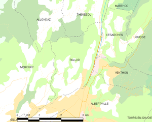
Allondaz (Allondaz)

- коммуна во Франции
 Hiking in Allondaz
Allondaz is a great destination for hiking enthusiasts, situated in the French Alps, near Albertville in the Savoie region. This area is characterized by picturesque landscapes, charming alpine villages, and a range of hiking trails suitable for various skill levels.
Hiking Trails:
-
Le Col de la Cochette: This trail offers stunning panoramic views of the surrounding peaks and is accessible for moderate hikers. The path typically takes around 4-5 hours round trip.
-
Lac de la Grande Lune: A beautiful hike that leads to a serene mountain lake. This trail is ideal for families and beginners, taking approximately 2-3 hours.
-
Les Crêtes de l'Arclusaz: For those seeking more challenge, this trail rewards hikers with spectacular ridge views. It's best suited for experienced hikers and can take 5-6 hours.
Best Time to Hike:
The hiking season in Allondaz generally runs from late spring to early autumn (May to October), with the best conditions typically found in the summer months when the weather is milder, and trails are well-marked.
Tips for Hiking in Allondaz:
- Gear Essentials: Make sure to wear proper hiking boots, and consider bringing trekking poles for stability, especially on steep or rocky sections.
- Navigation: It’s a good idea to carry local maps or download offline maps, as cell service can be spotty.
- Hydration and Snacks: Always carry enough water and snacks to keep your energy levels up during your hike, as resources on the trails may be limited.
- Respect Nature: Follow Leave No Trace principles to protect the natural environment and wildlife of the area.
Safety:
- Check the weather forecast before you go, as conditions in the Alps can change rapidly.
- Inform someone of your hiking plans and expected return time.
- Be aware of your limits and always be prepared to turn back if necessary.
With its stunning scenery and variety of trails, hiking in Allondaz can be an unforgettable experience. Whether you're a novice or an experienced hiker, there's a path for you to explore in this beautiful alpine region.
- Страна:

- Почтовый код: 73200
- Координаты: 45° 42' 22" N, 6° 22' 17" E


- GPS треки (wikiloc): [Ссылка]
- Площадь: 4.08 кв.км
- Население: 261
- Википедия английская: wiki(en)
- Википедия национальная: wiki(fr)
- Хранилище Wikidata: Wikidata: Q1222462
- Катеория в википедии: [Ссылка]
- код Freebase: [/m/03cb_vv]
- код GeoNames: Альт: [6450960]
- номер SIREN: [217300144]
- код BNF: [15273950d]
- код муниципалитета INSEE: 73014
Граничит с регионами:


Thénésol
- коммуна во Франции
Hiking in Thénésol
Thénésol is a picturesque village located in the French Alps, known for its stunning landscapes and proximity to a variety of hiking trails. Here are some highlights and tips for hiking in the Thénésol area:...
- Страна:
- Почтовый код: 73200
- Координаты: 45° 42' 44" N, 6° 23' 49" E
- GPS треки (wikiloc): [Ссылка]
- Площадь: 5.49 кв.км
- Население: 293

Паллю
- коммуна во Франции
Hiking in Паллю
It seems like you might be referring to a specific location that might not be widely recognized or documented in hiking resources. If "Pallud" is a less-known area, it could also be a local or regional term....
- Страна:
- Почтовый код: 73200
- Координаты: 45° 41' 12" N, 6° 23' 40" E
- GPS треки (wikiloc): [Ссылка]
- Площадь: 5.2 кв.км
- Население: 756


Меркюри
- коммуна во Франции
Hiking in Меркюри
Mercury, located in the Savoie region of the French Alps, is a charming village that offers access to a variety of hiking trails with stunning views of the surrounding mountains and valleys. Here are some key points to consider if you're planning to hike in this area:...
- Страна:
- Почтовый код: 73200
- Координаты: 45° 40' 27" N, 6° 20' 13" E
- GPS треки (wikiloc): [Ссылка]
- Площадь: 22.33 кв.км
- Население: 3046
- Веб сайт: [Ссылка]