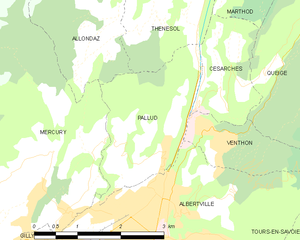
canton of Albertville-Nord (canton d'Albertville-Nord)
 Hiking in canton of Albertville-Nord
The Canton of Albertville-Nord, located in the Savoie region of France, offers a variety of hiking experiences that cater to different skill levels and interests. This area is known for its stunning landscapes, including mountains, valleys, and alpine lakes, making it a popular destination for outdoor enthusiasts.
Hiking Trails
-
Beaufortain Regional Natural Park: The park is close to Albertville-Nord and features numerous trails that offer breathtaking views and varying degrees of difficulty. Popular trails include those leading to the Col de la Forge and Lac de la Coop.
-
Les Arcs: This ski resort area in the vicinity of Albertville has trails suitable for summer hiking. You can experience both the challenge and beauty of mountain terrain.
-
Montagne de la Bétina: A great trail for those looking for a moderate hike while enjoying panoramic mountain views.
-
Trekking towards Les Aiguilles de la Vanoise: A more challenging option for experienced hikers, this route offers stunning views of glacial landscapes, especially rewarding during clear weather.
Difficulty Levels
- Beginner: Many well-marked paths are suitable for families and novice hikers. Make sure to stick to established trails.
- Intermediate: More extensive hikes that may include elevation gain and rocky paths.
- Advanced: For those looking for a challenge, high-altitude trails that require physical fitness and some scrambling.
Best Times to Hike
- Summer (June to September): This is the best time for hiking, with pleasant weather and fully accessible trails.
- Autumn (September to October): A beautiful time for hiking, featuring vibrant fall colors, although the weather can be more unpredictable.
Wildlife and Nature
The region is rich in biodiversity. Hikers may encounter various wildlife, including chamois, marmots, and diverse bird species. The flora is equally vibrant, featuring alpine flowers and unique plant species.
Preparation Tips
- Trail Maps: Always carry a detailed map or use a GPS. Trails can sometimes be poorly marked.
- Gear: Proper hiking boots, weather-appropriate clothing, and plenty of water are essential.
- Safety: Always inform someone about your hiking plans and check weather conditions before heading out.
Nearby Attractions
- Albertville: The town itself is a delightful stop with historical sites and dining options, especially known for hosting the 1992 Winter Olympics.
- Lake Annecy: A bit further afield but worth the visit for its charming lakeside and recreational activities.
Overall, the Canton of Albertville-Nord is a fantastic destination for hikers looking for adventure in the breathtaking French Alps. Enjoy your hike!
- Страна:

- Столица: Альбервиль
- Координаты: 45° 41' 30" N, 6° 23' 22" E


- GPS треки (wikiloc): [Ссылка]
- Википедия английская: wiki(en)
- Википедия национальная: wiki(fr)
- Хранилище Wikidata: Wikidata: Q1724067
- код Freebase: [/m/026d37k]
- код кантона INSEE: [7305]
Включает регионы:


Thénésol
- коммуна во Франции
Hiking in Thénésol
Thénésol is a picturesque village located in the French Alps, known for its stunning landscapes and proximity to a variety of hiking trails. Here are some highlights and tips for hiking in the Thénésol area:...
- Страна:
- Почтовый код: 73200
- Координаты: 45° 42' 44" N, 6° 23' 49" E
- GPS треки (wikiloc): [Ссылка]
- Площадь: 5.49 кв.км
- Население: 293
Вантон
- коммуна во Франции
Hiking in Вантон
Venthon is a beautiful destination for hiking enthusiasts, located in the Savoie region of the French Alps. The area offers a variety of hiking trails that cater to different skill levels, ranging from gentle walks to more challenging hikes....
- Страна:
- Почтовый код: 73200
- Координаты: 45° 41' 16" N, 6° 24' 49" E
- GPS треки (wikiloc): [Ссылка]
- Площадь: 2.5 кв.км
- Население: 635


Allondaz
- коммуна во Франции
Hiking in Allondaz
Allondaz is a great destination for hiking enthusiasts, situated in the French Alps, near Albertville in the Savoie region. This area is characterized by picturesque landscapes, charming alpine villages, and a range of hiking trails suitable for various skill levels....
- Страна:
- Почтовый код: 73200
- Координаты: 45° 42' 22" N, 6° 22' 17" E
- GPS треки (wikiloc): [Ссылка]
- Площадь: 4.08 кв.км
- Население: 261

Паллю
- коммуна во Франции
Hiking in Паллю
It seems like you might be referring to a specific location that might not be widely recognized or documented in hiking resources. If "Pallud" is a less-known area, it could also be a local or regional term....
- Страна:
- Почтовый код: 73200
- Координаты: 45° 41' 12" N, 6° 23' 40" E
- GPS треки (wikiloc): [Ссылка]
- Площадь: 5.2 кв.км
- Население: 756


Меркюри
- коммуна во Франции
Hiking in Меркюри
Mercury, located in the Savoie region of the French Alps, is a charming village that offers access to a variety of hiking trails with stunning views of the surrounding mountains and valleys. Here are some key points to consider if you're planning to hike in this area:...
- Страна:
- Почтовый код: 73200
- Координаты: 45° 40' 27" N, 6° 20' 13" E
- GPS треки (wikiloc): [Ссылка]
- Площадь: 22.33 кв.км
- Население: 3046
- Веб сайт: [Ссылка]
Césarches
- коммуна во Франции
Hiking in Césarches
Césarches is a lesser-known area for hiking, but it can offer beautiful views and a peaceful experience in nature, particularly if you're looking for a more secluded adventure. While detailed information might be sparse, the region generally features scenic landscapes, including forests, valleys, and streams....
- Страна:
- Почтовый код: 73200
- Координаты: 45° 42' 4" N, 6° 24' 43" E
- GPS треки (wikiloc): [Ссылка]
- Площадь: 2.9 кв.км
- Население: 425