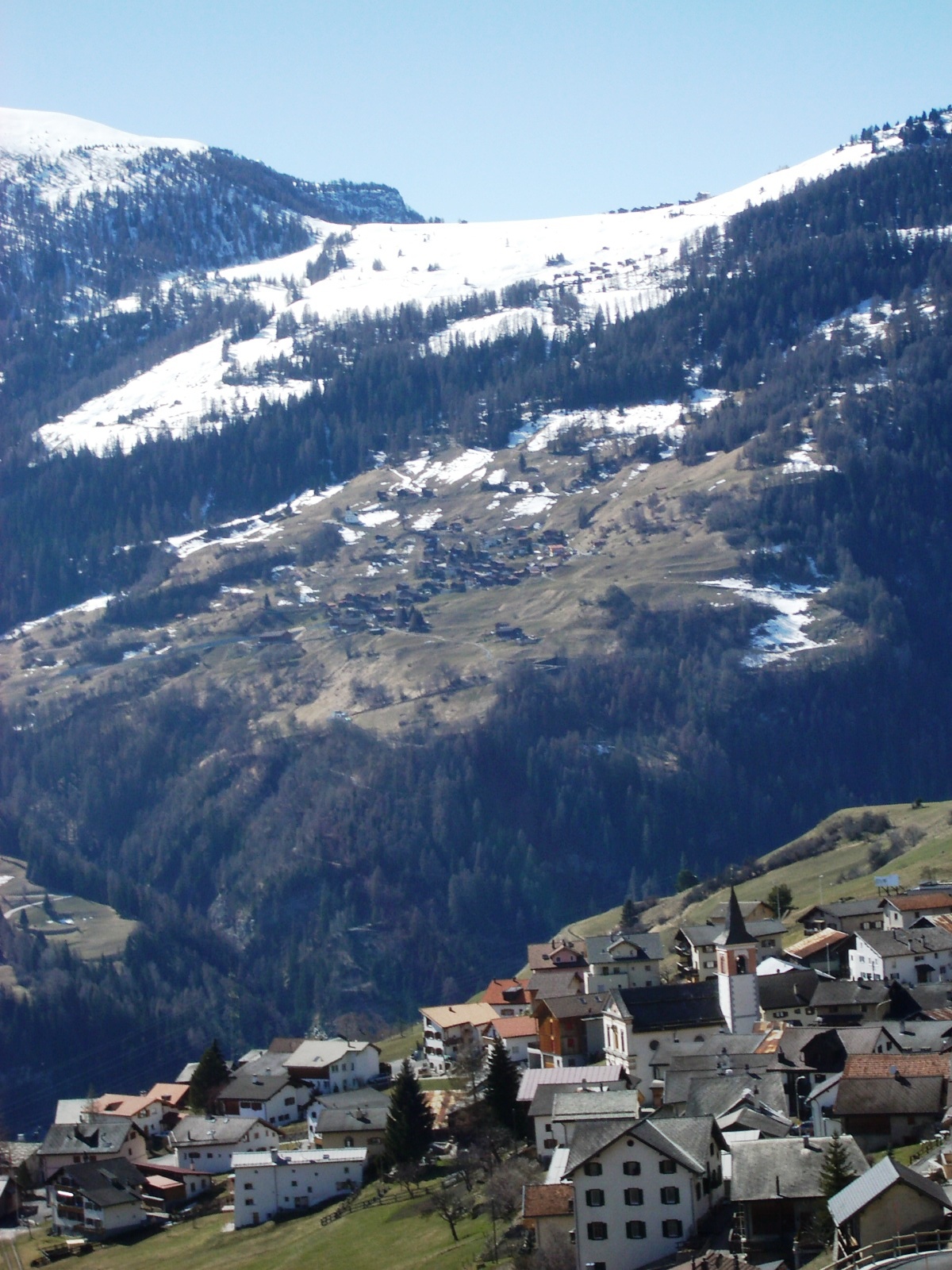
Альменс (Almens, Almens)


 Hiking in Альменс
Almens, a small village in the scenic region of Graubünden in Switzerland, offers beautiful hiking opportunities set against a backdrop of stunning Alpine landscapes. The area is characterized by its picturesque views, lush valleys, and pristine nature, making it a desirable destination for hikers of all skill levels.
Hiking Trails
-
Local Trails: There are several well-marked trails in and around Almens ranging from easy strolls to more challenging hikes. These trails often lead through enchanting forests, meadows filled with wildflowers, and provide stunning views of the Swiss Alps.
-
Alpine Trails: For more experienced hikers, there are alpine paths which may include steeper ascents and rugged terrain. Earning panoramic vistas and a sense of accomplishment, these routes often require good physical condition and proper gear.
-
Connecting Routes: Almens is also a great base for accessing longer trails in the region, including those leading towards the nearby towns and landmarks, such as the famous Arosa and Lenzerheide areas.
Things to Keep in Mind
-
Season: Hiking in the Alps can vary greatly with the seasons. Spring and summer offer warmer weather and accessible trails, while autumn provides stunning foliage. Winter may present snow-covered trails ideal for snowshoeing or winter hiking.
-
Preparation: Always check trail conditions beforehand, as weather can change rapidly in the mountains. Ensure you're equipped with suitable footwear, navigation tools, water, snacks, and layers of clothing to adapt to temperature changes.
-
Wildlife and Nature: The area is rich in biodiversity, so keep an eye out for local wildlife and take care to respect the natural environment.
Safety Tips
- Always inform someone about your hiking plans.
- Stay on marked trails to minimize your impact on the landscape.
- Be aware of altitude, as some trails may lead to higher elevations where oxygen levels are lower.
Hiking in Almens is an excellent way to experience the tranquility and beauty of the Swiss countryside, connecting with nature while enjoying the physical activity that comes with exploring the great outdoors. If you have specific trails in mind or further questions, feel free to ask!
- Страна:

- Почтовый код: 7416
- Телефонный код: 081
- Код автомобильного номера: GR
- Координаты: 46° 44' 20" N, 9° 27' 19" E


- GPS треки (wikiloc): [Ссылка]
- Высота над уровнем моря: 787 м m
- Площадь: 8.34 кв.км
- Веб сайт: http://www.almens.ch
- Википедия русская: wiki(ru)
- Википедия английская: wiki(en)
- Википедия национальная: wiki(de)
- Хранилище Wikidata: Wikidata: Q64226
- Катеория в википедии: [Ссылка]
- код Freebase: [/m/026dgbx]
- код GeoNames: Альт: [7285053]
- код VIAF: Альт: [310691671]
- код темы Quora: [ALMEN]
- идентификатор HDS: [1471]
- код швейцарского муниципалитета: [3631]
Граничит с регионами:


Шаранс
Hiking in Шаранс
Scharans is a picturesque village located in the Graubünden region of Switzerland, known for its stunning landscapes and variety of hiking opportunities. Here are some highlights and tips for hiking in and around Scharans:...
- Страна:
- Почтовый код: 7412
- Телефонный код: 081
- Код автомобильного номера: GR
- Координаты: 46° 43' 5" N, 9° 27' 32" E
- GPS треки (wikiloc): [Ссылка]
- Высота над уровнем моря: 1253 м m
- Площадь: 1459 кв.км
- Население: 807
- Веб сайт: [Ссылка]


Курвальден
Hiking in Курвальден
Churwalden, located in the Prättigau Valley of Switzerland, is a fantastic destination for hiking enthusiasts. Nestled in the picturesque Graubünden region, it offers a variety of scenic trails suitable for different skill levels and preferences. Here are some details to help you plan your hiking experience in Churwalden:...
- Страна:
- Почтовый код: 7075
- Телефонный код: 081
- Код автомобильного номера: GR
- Координаты: 46° 47' 21" N, 9° 32' 20" E
- GPS треки (wikiloc): [Ссылка]
- Высота над уровнем моря: 1159 м m
- Площадь: 48.54 кв.км
- Население: 2012
- Веб сайт: [Ссылка]

Вац
- коммуна в кантоне Граубюнден (Швейцария)
Hiking in Вац
Vaz Obervaz, also known simply as Vaz, is a charming municipality located in the Grisons (Graubünden) region of Switzerland. It's a great destination for hiking enthusiasts due to its stunning landscapes, diverse trails, and access to the surrounding mountains....
- Страна:
- Почтовый код: 7082
- Телефонный код: 081
- Код автомобильного номера: GR
- Координаты: 46° 42' 59" N, 9° 33' 0" E
- GPS треки (wikiloc): [Ссылка]
- Высота над уровнем моря: 1300 м m
- Площадь: 42.51 кв.км
- Население: 2630
- Веб сайт: [Ссылка]


Родельс
Hiking in Родельс
Rodels, a picturesque village located in the canton of Graubünden in Switzerland, offers stunning hiking opportunities amidst breathtaking Alpine scenery. Here are some highlights and tips for hiking in Rodels:...
- Страна:
- Почтовый код: 7415
- Телефонный код: 081
- Код автомобильного номера: GR
- Координаты: 46° 43' 59" N, 9° 26' 0" E
- GPS треки (wikiloc): [Ссылка]
- Высота над уровнем моря: 684 м m
- Площадь: 1.68 кв.км
- Веб сайт: [Ссылка]


Пратваль
Hiking in Пратваль
Pratval, located in the scenic valleys of the Himalayas, is an excellent destination for hiking enthusiasts. This area is celebrated for its stunning landscapes, diverse flora and fauna, and a variety of trails suitable for hikers of all experience levels....
- Страна:
- Почтовый код: 7415
- Телефонный код: 081
- Код автомобильного номера: GR
- Координаты: 46° 42' 59" N, 9° 26' 0" E
- GPS треки (wikiloc): [Ссылка]
- Высота над уровнем моря: 687 м m
- Площадь: 0.77 кв.км
- Веб сайт: [Ссылка]


Фюрстенау
Hiking in Фюрстенау
Fürstenau, located in the Swiss canton of Graubünden, is a charming village that offers a range of beautiful hiking opportunities amidst the stunning landscapes of the Swiss Alps. Here’s what you need to know about hiking in this area:...
- Страна:
- Почтовый код: 7414
- Телефонный код: 081
- Код автомобильного номера: GR
- Координаты: 46° 42' 59" N, 9° 26' 0" E
- GPS треки (wikiloc): [Ссылка]
- Высота над уровнем моря: 650 м m
- Площадь: 1.32 кв.км
- Население: 349
- Веб сайт: [Ссылка]

Паспельс
Hiking in Паспельс
Paspels is a charming village located in the canton of Grisons (Graubünden) in Switzerland. Nestled in the picturesque landscape, it serves as a great base for various hiking adventures. Here’s what you can expect when hiking in and around Paspels:...
- Страна:
- Почтовый код: 7417
- Телефонный код: 081
- Код автомобильного номера: GR
- Координаты: 46° 43' 59" N, 9° 26' 0" E
- GPS треки (wikiloc): [Ссылка]
- Высота над уровнем моря: 778 м m
- Площадь: 4.59 кв.км
- Веб сайт: [Ссылка]