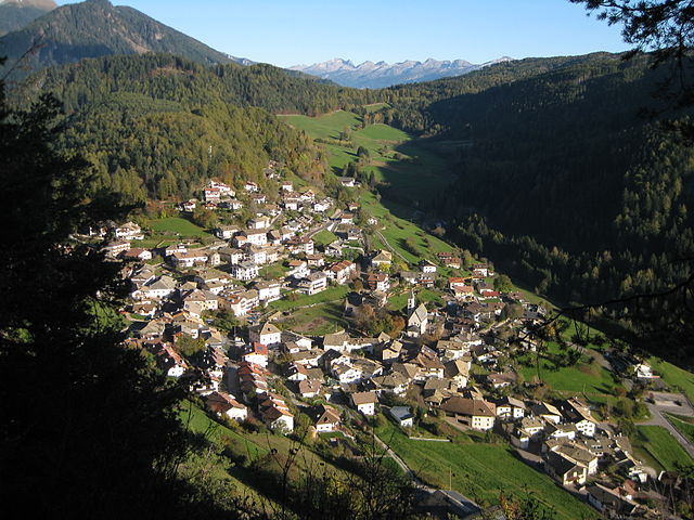
Антериво (Altrei, Anterivo)
.svg)
- коммуна Италии
 Hiking in Антериво
Altrei is a charming village located in the South Tyrol region of northern Italy. It is surrounded by stunning natural landscapes, making it a great destination for hiking enthusiasts. Here are some key points about hiking in Altrei:
Trails and Routes:
-
Variety of Trails: Altrei offers a range of hiking trails suitable for different levels of experience, from easy walks to more challenging hikes. Many routes take you through picturesque forests, meadows, and stunning mountain vistas.
-
Natural Surroundings: The area is part of the beautiful Trentino-Alto Adige region, characterized by its lush greenery, Alpine flora, and varied wildlife. Hikers can expect to see breathtaking views, especially of the nearby Dolomites.
-
Influence of Local Culture: Some trails also lead to historically significant sites or offer insights into the local culture and traditions, providing a richer experience beyond just the physical activity.
Popular Hiking Routes:
- Path of the Senses: A nearby trail that integrates nature and sensory experiences. This path is usually family-friendly and suitable for all ages.
- The Kalterer See Circuit: Along this route, hikers can enjoy panoramic views of the lake and surrounding vineyards.
- Hikes into the Dolomites: More experienced hikers can tackle routes that lead deeper into the Dolomites for incredible alpine scenery.
Best Time to Visit:
- Summer and Early Fall: These seasons are ideal for hiking, as weather conditions are usually pleasant, and trails are fully accessible. Spring is also beautiful when wildflowers are in bloom, but some higher trails may still be snow-covered.
- Autumn: The changing colors of the leaves create stunning landscapes perfect for photography.
Preparation Tips:
- Gear Up: Use appropriate hiking boots, dress in layers, and carry sufficient water and snacks. The weather can change rapidly, especially in the mountains.
- Navigation: Consider using local maps or apps for trail navigation, as some paths may not be well-marked.
Local Amenities:
- Accommodations: Altrei offers various lodging options, from guesthouses to hotels, catering to different budgets. Many allow you to enjoy local cuisine after a day of hiking.
- Guided Tours: If you prefer, you can find local guides who offer organized hikes, which can be a great way to learn more about the area.
In summary, hiking in Altrei allows you to experience the natural beauty of South Tyrol while enjoying a variety of trails suitable for various skill levels. Whether you're looking for a leisurely stroll or an adventurous trek, Altrei is an excellent choice for outdoor enthusiasts.
- Страна:

- Почтовый код: 39040
- Телефонный код: 0471
- Код автомобильного номера: BZ
- Координаты: 46° 16' 41" N, 11° 22' 0" E


- GPS треки (wikiloc): [Ссылка]
- Высота над уровнем моря: 1635 м m
- Площадь: 11.06 кв.км
- Население: 396
- Веб сайт: http://www.gemeinde.altrei.bz.it
- Википедия русская: wiki(ru)
- Википедия английская: wiki(en)
- Википедия национальная: wiki(it)
- Хранилище Wikidata: Wikidata: Q374108
- Галерея изображений в википедии: [Ссылка]
- Катеория в википедии: [Ссылка]
- код Freebase: [/m/0g9f0z]
- код GeoNames: Альт: [6535885]
- код VIAF: Альт: [237000276]
- ID отношения в OpenStreetMap: [47075]
- код GND: Альт: [4528028-9]
- код ISTAT: 021003
- кадастровый код Италии: A306
Граничит с регионами:
Кастелло-Молина-ди-Фьемме
- коммуна Италии
Hiking in Кастелло-Молина-ди-Фьемме
Castello-Molina di Fiemme is a picturesque area located in the Val di Fiemme region of the Trentino-Alto Adige/Südtirol in northern Italy. It offers a range of hiking opportunities amid stunning landscapes characterized by lush meadows, dense forests, and impressive mountain scenery that is typical of the Dolomites....
- Страна:
- Почтовый код: 38030
- Телефонный код: 0462
- Код автомобильного номера: TN
- Координаты: 46° 16' 19" N, 11° 25' 2" E
- GPS треки (wikiloc): [Ссылка]
- Высота над уровнем моря: 900 м m
- Площадь: 54.56 кв.км
- Население: 2307
- Веб сайт: [Ссылка]


Каприана
- коммуна Италии
Hiking in Каприана
Capriana is a beautiful destination in the Trentino region of Italy that offers a variety of hiking opportunities characterized by stunning natural landscapes, rich flora and fauna, and panoramic views of the surrounding mountains and valleys. Here are some key points to consider when planning a hiking excursion in Capriana:...
- Страна:
- Почтовый код: 38030
- Телефонный код: 0462
- Код автомобильного номера: TN
- Координаты: 46° 16' 0" N, 11° 20' 0" E
- GPS треки (wikiloc): [Ссылка]
- Высота над уровнем моря: 1007 м m
- Площадь: 12.82 кв.км
- Население: 589
- Веб сайт: [Ссылка]


Карано
- коммуна Италии
Hiking in Карано
Carano is a picturesque village located in the Trentino-Alto Adige region of northern Italy. Surrounded by stunning landscapes and mountains, it is an excellent destination for hiking enthusiasts. Here are some highlights about hiking in and around Carano:...
- Страна:
- Почтовый код: 38033
- Телефонный код: 0462
- Код автомобильного номера: TN
- Координаты: 46° 17' 29" N, 11° 26' 23" E
- GPS треки (wikiloc): [Ссылка]
- Высота над уровнем моря: 1100 м m
- Площадь: 13.57 кв.км
- Население: 1090
- Веб сайт: [Ссылка]


Вальфлориана
- коммуна Италии
Hiking in Вальфлориана
Valfloriana is a picturesque area located in the Trentino region of northern Italy, known for its stunning landscapes, rich biodiversity, and charming villages. Hiking in Valfloriana offers a fantastic experience for outdoor enthusiasts, with a variety of trails suitable for different skill levels....
- Страна:
- Почтовый код: 38040
- Телефонный код: 0462
- Код автомобильного номера: TN
- Координаты: 46° 15' 0" N, 11° 21' 0" E
- GPS треки (wikiloc): [Ссылка]
- Высота над уровнем моря: 853 м m
- Площадь: 39.33 кв.км
- Население: 470
- Веб сайт: [Ссылка]

Тродена-нель-парко-натурале
- коммуна в Италии
Hiking in Тродена-нель-парко-натурале
Truden im Naturpark, located in the South Tyrol region of northern Italy, is a beautiful destination for hiking enthusiasts. It is nestled within the larger Rosengarten-Latemar Nature Park, which offers diverse landscapes, including lush forests, meadows, and stunning mountain views....
- Страна:
- Почтовый код: 39040
- Телефонный код: 0471
- Код автомобильного номера: BZ
- Координаты: 46° 19' 19" N, 11° 20' 59" E
- GPS треки (wikiloc): [Ссылка]
- Высота над уровнем моря: 719 м m
- Площадь: 20.56 кв.км
- Население: 1027
- Веб сайт: [Ссылка]