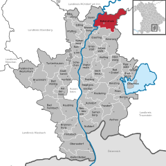
Амеранг (Amerang, Amerang)

 Hiking in Амеранг
Amerang, located in Bavaria, Germany, is a picturesque area that offers various hiking opportunities. The region is characterized by its beautiful landscapes, rolling hills, and lush green forests, making it an ideal spot for nature lovers and outdoor enthusiasts.
Popular Hiking Trails:
-
Amerang Circular Route: This moderate trail allows hikers to experience the charm of Amerang and its surroundings. It typically spans around 10 kilometers and provides lovely views of the Bavarian countryside.
-
Trails in the Chiemgau Alps: While Amerang itself is not in the Alps, it's a short drive from trails that lead into the foothills of the Chiemgau Alps. These trails vary in difficulty and offer stunning alpine scenery.
-
Nearby Nature Reserves: Check out trails in surrounding nature reserves, such as the Chiemsee region, where flat lakeside paths are available alongside more rugged routes leading into wooded areas.
Tips for Hiking in Amerang:
- Best Time to Hike: Late spring through early autumn is ideal due to mild weather and vibrant flora. The fall also offers beautiful foliage.
- Footwear: Sturdy hiking boots are recommended, especially if you plan to venture onto more rugged terrain.
- Local Wildlife: Be aware of local wildlife. While most encounters are harmless, it’s good to stay cautious and respect the natural habitat.
- Carry Essentials: Always bring water, snacks, a map or GPS device, and a first aid kit when hiking.
Hiking Etiquette:
- Stay on marked trails to preserve the environment.
- Pack out what you pack in, leaving no trace.
- Respect other hikers by maintaining a friendly and quiet demeanor.
Local Amenities:
Amerang offers small cafes and local eateries where you can enjoy Bavarian cuisine after your hike. Additionally, it’s a good idea to check local websites or information centers for any guided hiking tours or organized events.
Hiking in and around Amerang can be a delightful experience, combining the beauty of nature with the tranquility of the Bavarian countryside. Always make sure to check local weather conditions before heading out and enjoy your adventure!
- Страна:

- Почтовый код: 83123
- Телефонный код: 08075
- Код автомобильного номера: RO
- Координаты: 47° 59' 30" N, 12° 18' 34" E


- GPS треки (wikiloc): [Ссылка]
- Высота над уровнем моря: 537 м m
- Площадь: 39.80 кв.км
- Население: 2727
- Веб сайт: http://www.amerang.de/
- Википедия русская: wiki(ru)
- Википедия английская: wiki(en)
- Википедия национальная: wiki(de)
- Хранилище Wikidata: Wikidata: Q463022
- Катеория в википедии: [Ссылка]
- код Freebase: [/m/02q7c5f]
- код GeoNames: Альт: [2956570]
- код VIAF: Альт: [157085834]
- ID отношения в OpenStreetMap: [2156163]
- код GND: Альт: [4001667-5]
- код LCNAF: Альт: [n78045662]
- место в MusicBrainz: [530c6e72-f1b5-477f-a904-1166f7f66490]
- WOEID: [635000]
- Bavarikon ID: [ODB_A00001293]
- идентификатор муниципалитетов в Германии: 09187113
Граничит с регионами:

Бабенсхам
Hiking in Бабенсхам
Babensham is a village in the scenic surroundings of the North Yorkshire Moors in England, making it a lovely spot for hiking enthusiasts. The region typically offers beautiful walking trails, including routes that traverse through woodlands, along river valleys, and up to hilltops with breathtaking views....
- Страна:
- Почтовый код: 83547
- Телефонный код: 08071
- Код автомобильного номера: RO
- Координаты: 48° 5' 0" N, 12° 16' 0" E
- GPS треки (wikiloc): [Ссылка]
- Высота над уровнем моря: 488 м m
- Площадь: 54.31 кв.км
- Население: 2349
- Веб сайт: [Ссылка]
Айзельфинг
Hiking in Айзельфинг
Eiselfing is a charming municipality located in Bavaria, Germany, known for its picturesque landscapes and proximity to several hiking opportunities in the surrounding areas. While Eiselfing itself might not be a major hiking destination with extensive trails, it serves as an excellent base for exploring the nearby regions, including the foothills of the Alps....
- Страна:
- Почтовый код: 83549
- Телефонный код: 08071
- Код автомобильного номера: RO
- Координаты: 48° 3' 0" N, 12° 14' 0" E
- GPS треки (wikiloc): [Ссылка]
- Высота над уровнем моря: 470 м m
- Площадь: 34.89 кв.км
- Население: 2429
- Веб сайт: [Ссылка]