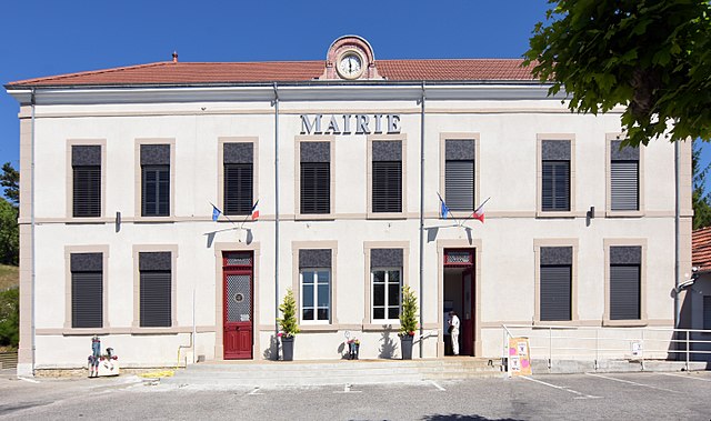
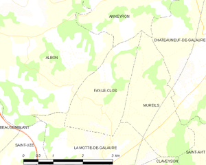
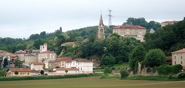
Аннейрон (Anneyron, Anneyron)

- коммуна во Франции
 Hiking in Аннейрон
Anneyron is a charming town located in the Drôme department in southeastern France. Nestled in the Rhône Valley, it's a great starting point for exploring the surrounding natural landscapes. Here are some highlights and tips for hiking in and around Anneyron:
Scenic Trails
-
Local Trails: Anneyron offers several local hiking trails that provide a mix of easy walks and more challenging hikes. You can enjoy beautiful views of the surrounding countryside, vineyards, and forests.
-
The Pilat Regional Natural Park: Just a short drive away, this park offers extensive hiking opportunities with well-marked trails. You'll find diverse landscapes, including hills, valleys, and rivers, along with stunning views over the Rhône valley.
-
The Vercors: A bit further from Anneyron, the Vercors mountain range provides a variety of hikes suited for all levels. It features rugged cliffs, deep gorges, and rich biodiversity.
Things to Consider
-
Trail Difficulty: Always check the trail difficulty before heading out. Many trails around Anneyron are accessible for families, but there are also more challenging paths for seasoned hikers.
-
Weather Conditions: The weather can change quickly in the region, especially in the mountains. Check the forecast and prepare accordingly with appropriate clothing and gear.
-
Hydration and Snacks: Bring sufficient water and snacks, especially since some trails may be longer and more remote.
-
Local Maps and Resources: Consider getting a local map or using hiking apps to help navigate the trails. There are often visitor centers where you can obtain information.
Cultural Attractions
-
After your hike, take time to explore the town of Anneyron. It has historical sites, local markets, and cafés where you can relax and enjoy the regional cuisine.
-
Don’t miss the nearby vineyards which often welcome visitors for wine tastings, perfect after a long day of hiking.
Safety Tips
- Always inform someone about your hiking plans and expected return time.
- Carry a basic first-aid kit and know the emergency contact numbers in the area.
Exploring the hiking opportunities around Anneyron can be a rewarding experience filled with stunning views and the tranquility of nature. Enjoy your time out on the trails!
- Страна:

- Почтовый код: 26140
- Координаты: 45° 16' 16" N, 4° 53' 16" E


- GPS треки (wikiloc): [Ссылка]
- Площадь: 36.23 кв.км
- Население: 3924
- Веб сайт: http://www.anneyron.fr
- Википедия английская: wiki(en)
- Википедия национальная: wiki(fr)
- Хранилище Wikidata: Wikidata: Q863563
- Катеория в википедии: [Ссылка]
- код Freebase: [/m/03mgk5g]
- код GeoNames: Альт: [6447863]
- номер SIREN: [212600100]
- код BNF: [15252871f]
- код муниципалитета INSEE: 26010
Граничит с регионами:

Épinouze
- коммуна во Франции
Hiking in Épinouze
Épinouze is a charming commune located in the Drôme department of southeastern France. It is surrounded by picturesque landscapes, making it a great spot for hiking enthusiasts. Here are some highlights and tips for hiking in the Épinouze area:...
- Страна:
- Почтовый код: 26210
- Координаты: 45° 18' 33" N, 4° 55' 40" E
- GPS треки (wikiloc): [Ссылка]
- Площадь: 11.21 кв.км
- Население: 1594
- Веб сайт: [Ссылка]

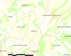
Mureils
- коммуна во Франции
Hiking in Mureils
It seems like you might be referring to a specific area or hiking location, but "Mureils" doesn't appear to be a widely recognized hiking destination or location as of my last knowledge update in October 2023. It’s possible you meant a different location with a similar name or a less commonly known local site....
- Страна:
- Почтовый код: 26240
- Координаты: 45° 12' 32" N, 4° 55' 48" E
- GPS треки (wikiloc): [Ссылка]
- Площадь: 5.45 кв.км
- Население: 466


Буже-Шамбалю
- коммуна во Франции
Hiking in Буже-Шамбалю
Bougé-Chambalud is a picturesque village located in the Auvergne-Rhône-Alpes region of France, specifically within the department of Drôme. Its setting offers several opportunities for hiking and enjoying the natural beauty of the area....
- Страна:
- Почтовый код: 38150
- Координаты: 45° 19' 49" N, 4° 54' 5" E
- GPS треки (wikiloc): [Ссылка]
- Площадь: 15.85 кв.км
- Население: 1395
- Веб сайт: [Ссылка]


Saint-Sorlin-en-Valloire
- коммуна во Франции
Hiking in Saint-Sorlin-en-Valloire
Saint-Sorlin-en-Valloire is a picturesque village located in the French Alps, known for its stunning natural beauty and an array of outdoor activities, especially hiking. Here are some highlights and tips for hiking in this beautiful area:...
- Страна:
- Почтовый код: 26210
- Координаты: 45° 17' 21" N, 4° 57' 5" E
- GPS треки (wikiloc): [Ссылка]
- Площадь: 26.5 кв.км
- Население: 2233

Saint-Rambert-d'Albon
- коммуна во Франции
- Страна:
- Почтовый код: 26140
- Координаты: 45° 17' 38" N, 4° 49' 1" E
- GPS треки (wikiloc): [Ссылка]
- Площадь: 13.41 кв.км
- Население: 6313
- Веб сайт: [Ссылка]

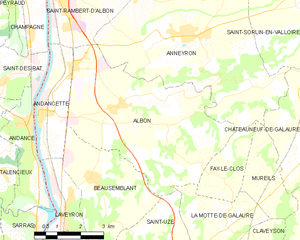
Albon
- Страна:
- Почтовый код: 26140
- Координаты: 45° 14' 44" N, 4° 50' 56" E
- GPS треки (wikiloc): [Ссылка]
- Площадь: 25.62 кв.км
- Население: 1879

Fay-le-Clos
- коммуна во Франции
Hiking in Fay-le-Clos
Fay-le-Clos is a charming destination situated in the scenic region of France, known for its natural beauty and peaceful landscapes. While it may not be as widely known as some other hiking spots, it offers a variety of opportunities for outdoor enthusiasts....
- Страна:
- Почтовый код: 26240
- Координаты: 45° 12' 48" N, 4° 54' 21" E
- GPS треки (wikiloc): [Ссылка]
- Площадь: 4.56 кв.км
- Население: 169

Châteauneuf-de-Galaure
- коммуна во Франции
Hiking in Châteauneuf-de-Galaure
Châteauneuf-de-Galaure is a charming village located in the Auvergne-Rhône-Alpes region of France, known for its picturesque landscapes and access to hiking trails. Here are some points of interest for hiking in and around Châteauneuf-de-Galaure:...
- Страна:
- Почтовый код: 26330
- Координаты: 45° 13' 55" N, 4° 57' 25" E
- GPS треки (wikiloc): [Ссылка]
- Площадь: 18.08 кв.км
- Население: 1770