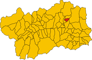
Анте-Сент-Андре (Antey-Saint-André, Antey-Saint-André)
.svg)
- коммуна Италии
 Hiking in Анте-Сент-Андре
Antey-Saint-André is a charming commune located in the Aosta Valley region of Italy, surrounded by stunning Alpine scenery, making it a great destination for hiking enthusiasts. Here are some key points to consider for hiking in this area:
Trails and Terrain
- Variety of Trails: Antey-Saint-André offers a variety of hiking trails suited for different skill levels, from easy walks suitable for families to challenging climbs for experienced hikers.
- Scenic Routes: Many trails offer breathtaking views of the surrounding mountains, vineyards, and the valley. The trails often lead to picturesque spots like the nearby mountains of the Matterhorn and Monte Rosa.
- Wildlife and Flora: Hikers can enjoy the rich biodiversity in the region, including various species of plants and wildlife. Keep an eye out for the unique alpine flora and fauna.
Hiking Recommendations
- Trail Guides: It’s advisable to use local maps or guides, as well-marked trails may not always be evident. The local tourist information center can provide resources and advice.
- Best Seasons: The best time for hiking generally falls between late spring and early autumn (May to September), when the weather is milder and the trails are more accessible.
- Difficulty Levels: Assess your fitness level and choose trails that match your abilities to ensure a safe and enjoyable experience.
Safety Tips
- Check Weather Conditions: Mountain weather can change rapidly, so always check the forecast before heading out.
- Proper Gear: Make sure to wear suitable hiking footwear and pack essentials such as water, snacks, a first-aid kit, and a map.
- Stay Hydrated: Especially in warmer months, carry enough water to stay hydrated throughout your hike.
Local Attractions
- Cultural Sites: Combine hiking with a bit of local culture; visit local historic sites and enjoy regional cuisine in the village after your hike.
- Festivals and Events: Keep an eye out for local events or festivals that may coincide with your visit, which can enhance your hiking experience.
Accessibility
- Getting There: Antey-Saint-André is accessible by car and public transportation, with options for local transportation to get to trailheads.
Whether you are looking for a leisurely hike or a more strenuous adventure, Antey-Saint-André has something to offer for every hiking enthusiast. Enjoy the beauty of the Alps and take in the unique atmosphere of this beautiful region!
- Страна:

- Почтовый код: 11020
- Телефонный код: 0166
- Код автомобильного номера: AO
- Координаты: 45° 48' 0" N, 7° 36' 0" E


- GPS треки (wikiloc): [Ссылка]
- Высота над уровнем моря: 1074 м m
- Площадь: 11.81 кв.км
- Население: 573
- Веб сайт: http://www.comune.antey-st-andre.ao.it
- Википедия русская: wiki(ru)
- Википедия английская: wiki(en)
- Википедия национальная: wiki(it)
- Хранилище Wikidata: Wikidata: Q34748
- Катеория в википедии: [Ссылка]
- Карты в википедии: [Ссылка]
- код Freebase: [/m/0fszyd]
- код GeoNames: Альт: [6535879]
- ID отношения в OpenStreetMap: [46164]
- код ISTAT: 007002
- кадастровый код Италии: A305
Граничит с регионами:


Шамуа
- коммуна Италии
Hiking in Шамуа
Chamois is a charming village located in the Aosta Valley region of Italy. It is known for its stunning natural scenery, making it a fantastic destination for hiking enthusiasts. Here are some key points about hiking in Chamois:...
- Страна:
- Почтовый код: 11020
- Телефонный код: 0166
- Код автомобильного номера: AO
- Координаты: 45° 50' 0" N, 7° 37' 0" E
- GPS треки (wikiloc): [Ссылка]
- Высота над уровнем моря: 1800 м m
- Площадь: 14.53 кв.км
- Население: 95
- Веб сайт: [Ссылка]


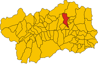
Шатийон
- коммуна Италии
Hiking in Шатийон
Châtillon is a charming town located in the Aosta Valley region of Italy, surrounded by stunning mountainous landscapes that make it a great starting point for hiking enthusiasts. Here’s what you should know about hiking in and around Châtillon:...
- Страна:
- Почтовый код: 11024
- Телефонный код: 0166
- Код автомобильного номера: AO
- Координаты: 45° 45' 0" N, 7° 37' 0" E
- GPS треки (wikiloc): [Ссылка]
- Высота над уровнем моря: 549 м m
- Площадь: 39.68 кв.км
- Население: 4654
- Веб сайт: [Ссылка]

Ла-Магделен
- коммуна Италии
Hiking in Ла-Магделен
La Magdeleine is a beautiful area located in the Aosta Valley region of Italy, known for its stunning landscapes, rich culture, and outdoor activities. While it might not be as widely recognized as some other hiking destinations in the Alps, it offers a range of hiking opportunities for both beginners and experienced hikers....
- Страна:
- Почтовый код: 11020
- Телефонный код: 0166
- Код автомобильного номера: AO
- Координаты: 45° 49' 0" N, 7° 37' 0" E
- GPS треки (wikiloc): [Ссылка]
- Высота над уровнем моря: 1644 м m
- Площадь: 8.94 кв.км
- Население: 108
- Веб сайт: [Ссылка]
Сен-Дени
- коммуна Италии
Hiking in Сен-Дени
Saint-Denis in the Aosta Valley is a beautiful location for hiking, surrounded by stunning alpine landscapes and offering a variety of trails suited for different skill levels. Here are some key points about hiking in this region:...
- Страна:
- Почтовый код: 11023
- Телефонный код: 0166
- Код автомобильного номера: AO
- Координаты: 45° 45' 0" N, 7° 33' 0" E
- GPS треки (wikiloc): [Ссылка]
- Высота над уровнем моря: 820 м m
- Площадь: 11.39 кв.км
- Население: 369
- Веб сайт: [Ссылка]

Торньон
- коммуна Италии
Hiking in Торньон
Torgnon is a beautiful village located in the Aosta Valley region of Italy, nestled in the Italian Alps. It's known for its stunning landscapes, lush valleys, and pristine nature, making it an ideal destination for hiking enthusiasts. Here are some key points about hiking in Torgnon:...
- Страна:
- Почтовый код: 11020
- Телефонный код: 0166
- Код автомобильного номера: AO
- Координаты: 45° 48' 0" N, 7° 34' 0" E
- GPS треки (wikiloc): [Ссылка]
- Высота над уровнем моря: 1489 м m
- Площадь: 42.46 кв.км
- Население: 587
- Веб сайт: [Ссылка]


Вальтурнанш
- коммуна Италии
Hiking in Вальтурнанш
Valtournenche, located in the Aosta Valley of Italy near the Swiss border, is a stunning destination for hiking enthusiasts. It's well-known for its breathtaking mountain scenery, including views of the iconic Matterhorn, which is particularly visible from the valley and its surrounding areas. Here are some highlights about hiking in Valtournenche:...
- Страна:
- Почтовый код: 11028
- Телефонный код: 0166
- Код автомобильного номера: AO
- Координаты: 45° 53' 0" N, 7° 37' 0" E
- GPS треки (wikiloc): [Ссылка]
- Высота над уровнем моря: 1528 м m
- Площадь: 116.15 кв.км
- Население: 2294
- Веб сайт: [Ссылка]