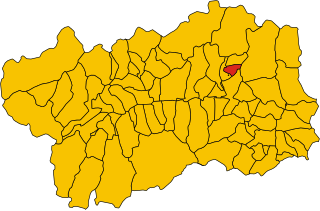
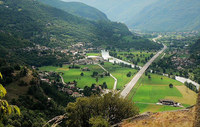
Шатийон (Châtillon, Châtillon)
.svg)
- коммуна Италии
 Hiking in Шатийон
Châtillon is a charming town located in the Aosta Valley region of Italy, surrounded by stunning mountainous landscapes that make it a great starting point for hiking enthusiasts. Here’s what you should know about hiking in and around Châtillon:
Scenic Trails
-
Alpine Trails: The area features various trails suitable for all skill levels, from easy walks to more challenging treks. You can explore lush forests, alpine meadows, and picturesque views of the surrounding peaks.
-
Lakes and Streams: Several trails lead to beautiful lakes, like Lake Blu, where you can enjoy a peaceful rest and take in the scenery. The trails often follow streams, offering pleasant sounds of water throughout your hike.
-
Historical Routes: Some hikes also incorporate cultural and historical sites, such as old churches and castles, allowing you to soak in the rich history of the region while enjoying nature.
Popular Hiking Areas
-
Mont Avic Natural Park: Just a short distance from Châtillon, this park offers a plethora of trails and is home to diverse flora and fauna. It's an excellent area for both hiking and wildlife watching.
-
Torgnon: Located nearby, Torgnon offers numerous hiking trails featuring stunning panoramic views of the Matterhorn and surrounding peaks. It’s reachable from Châtillon and is ideal for both summer and early autumn hikes.
-
Saint-Vincent: The neighboring town of Saint-Vincent also has beautiful trails and is known for its thermal baths, providing a perfect end to a day of hiking.
Preparation and Tips
-
Gear: Ensure you have sturdy hiking boots, appropriate clothing for changing weather conditions, plenty of water, and snacks. A hiking map or GPS device may also be beneficial as some trails can be less well-marked.
-
Weather: The weather can be unpredictable in the mountains, so it's essential to check the forecast before heading out and be prepared for sudden changes.
-
Local Guides: If you’re unfamiliar with the area or if you’d like to explore more challenging routes, consider hiring a local guide who can provide insights into the best trails and the natural environment.
-
Respect Nature: Follow the Leave No Trace principles to preserve the beauty of the area and respect local wildlife.
Accessibility
Châtillon is easily accessible by car or public transport, with train services connecting it to other towns in the Aosta Valley. This makes it a convenient base for exploring the surrounding mountains and hiking routes.
Conclusion
Hiking in Châtillon, Aosta Valley offers a wonderful blend of natural beauty, adventure, and cultural exploration. Whether you’re seeking a leisurely stroll or a vigorous trek, the region has something to cater to every hiker's needs. Enjoy your hikes and soak in the breathtaking views!
- Страна:

- Почтовый код: 11024
- Телефонный код: 0166
- Код автомобильного номера: AO
- Координаты: 45° 45' 0" N, 7° 37' 0" E


- GPS треки (wikiloc): [Ссылка]
- Высота над уровнем моря: 549 м m
- Площадь: 39.68 кв.км
- Население: 4654
- Веб сайт: http://www.comune.chatillon.ao.it/
- Википедия русская: wiki(ru)
- Википедия английская: wiki(en)
- Википедия национальная: wiki(it)
- Хранилище Wikidata: Wikidata: Q34966
- Катеория в википедии: [Ссылка]
- Карты в википедии: [Ссылка]
- код Freebase: [/m/0fs_xt]
- код GeoNames: Альт: [6542138]
- код VIAF: Альт: [144380489]
- ID отношения в OpenStreetMap: [2526]
- код LCNAF: Альт: [n90705018]
- WOEID: [713929]
- UN/LOCODE: [ITCHN]
- код Цифрового атласа Римской империи: [41538]
- код BabelNet: [03452045n]
- код ISTAT: 007020
- кадастровый код Италии: C294
Граничит с регионами:


Анте-Сент-Андре
- коммуна Италии
Hiking in Анте-Сент-Андре
Antey-Saint-André is a charming commune located in the Aosta Valley region of Italy, surrounded by stunning Alpine scenery, making it a great destination for hiking enthusiasts. Here are some key points to consider for hiking in this area:...
- Страна:
- Почтовый код: 11020
- Телефонный код: 0166
- Код автомобильного номера: AO
- Координаты: 45° 48' 0" N, 7° 36' 0" E
- GPS треки (wikiloc): [Ссылка]
- Высота над уровнем моря: 1074 м m
- Площадь: 11.81 кв.км
- Население: 573
- Веб сайт: [Ссылка]


Аяс
- коммуна Италии
Hiking in Аяс
Ayas, located in the Aosta Valley region of Italy, is a stunning area known for its picturesque landscapes, charming alpine villages, and a variety of hiking trails that cater to different experience levels. Here are some highlights and recommendations for hiking in Ayas:...
- Страна:
- Почтовый код: 11020
- Телефонный код: 0125
- Код автомобильного номера: AO
- Координаты: 45° 48' 41" N, 7° 41' 12" E
- GPS треки (wikiloc): [Ссылка]
- Высота над уровнем моря: 1698 м m
- Площадь: 129.42 кв.км
- Население: 1377
- Веб сайт: [Ссылка]


Шамдепра
- коммуна Италии
Hiking in Шамдепра
Champdepraz is a picturesque commune located in the Aosta Valley region of Italy, surrounded by the stunning Alpine landscape, which makes it a great spot for hiking enthusiasts. The area features a variety of trails suitable for different skill levels, offering breathtaking views of the mountains, lush valleys, and traditional chalets....
- Страна:
- Почтовый код: 11020
- Телефонный код: 0125
- Код автомобильного номера: AO
- Координаты: 45° 41' 0" N, 7° 39' 0" E
- GPS треки (wikiloc): [Ссылка]
- Высота над уровнем моря: 523 м m
- Площадь: 48.79 кв.км
- Население: 714
- Веб сайт: [Ссылка]

Ла-Магделен
- коммуна Италии
Hiking in Ла-Магделен
La Magdeleine is a beautiful area located in the Aosta Valley region of Italy, known for its stunning landscapes, rich culture, and outdoor activities. While it might not be as widely recognized as some other hiking destinations in the Alps, it offers a range of hiking opportunities for both beginners and experienced hikers....
- Страна:
- Почтовый код: 11020
- Телефонный код: 0166
- Код автомобильного номера: AO
- Координаты: 45° 49' 0" N, 7° 37' 0" E
- GPS треки (wikiloc): [Ссылка]
- Высота над уровнем моря: 1644 м m
- Площадь: 8.94 кв.км
- Население: 108
- Веб сайт: [Ссылка]
Монжове
- коммуна Италии
Hiking in Монжове
Montjovet is a picturesque commune located in the Aosta Valley region of Italy, nestled in the foothills of the Alps. This area is known for its stunning landscapes, diverse ecosystems, and a variety of hiking opportunities that cater to different skill levels. Here are some key points to consider when hiking in Montjovet:...
- Страна:
- Почтовый код: 11020
- Телефонный код: 0166
- Код автомобильного номера: AO
- Координаты: 45° 42' 0" N, 7° 41' 0" E
- GPS треки (wikiloc): [Ссылка]
- Высота над уровнем моря: 406 м m
- Площадь: 18.76 кв.км
- Население: 1774
- Веб сайт: [Ссылка]


Понте
- коммуна в автономном регионе Валле-д’Аоста, Италия
Hiking in Понте
Pontey is a small village located in the Aosta Valley region of Italy, surrounded by picturesque landscapes and beautiful mountain scenery. It offers several hiking opportunities that are suitable for a range of skill levels, from beginner to more experienced hikers. Here are some key points about hiking in Pontey:...
- Страна:
- Почтовый код: 11024
- Телефонный код: 0166
- Код автомобильного номера: AO
- Координаты: 45° 44' 0" N, 7° 35' 0" E
- GPS треки (wikiloc): [Ссылка]
- Высота над уровнем моря: 523 м m
- Площадь: 15.75 кв.км
- Население: 815
- Веб сайт: [Ссылка]
Сен-Дени
- коммуна Италии
Hiking in Сен-Дени
Saint-Denis in the Aosta Valley is a beautiful location for hiking, surrounded by stunning alpine landscapes and offering a variety of trails suited for different skill levels. Here are some key points about hiking in this region:...
- Страна:
- Почтовый код: 11023
- Телефонный код: 0166
- Код автомобильного номера: AO
- Координаты: 45° 45' 0" N, 7° 33' 0" E
- GPS треки (wikiloc): [Ссылка]
- Высота над уровнем моря: 820 м m
- Площадь: 11.39 кв.км
- Население: 369
- Веб сайт: [Ссылка]


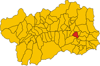
Сен-Венсан
- коммуна Италии
Hiking in Сен-Венсан
Saint-Vincent is a charming town located in the Aosta Valley region of Italy, nestled in the beautiful mountains of the Alps. The area is known not only for its rich history and thermal baths but also for its excellent hiking opportunities. Here are some key points about hiking in and around Saint-Vincent:...
- Страна:
- Почтовый код: 11027
- Телефонный код: 0166
- Код автомобильного номера: AO
- Координаты: 45° 45' 0" N, 7° 39' 0" E
- GPS треки (wikiloc): [Ссылка]
- Высота над уровнем моря: 550 м m
- Площадь: 20.57 кв.км
- Население: 4584
- Веб сайт: [Ссылка]

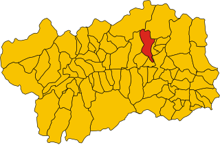
Торньон
- коммуна Италии
Hiking in Торньон
Torgnon is a beautiful village located in the Aosta Valley region of Italy, nestled in the Italian Alps. It's known for its stunning landscapes, lush valleys, and pristine nature, making it an ideal destination for hiking enthusiasts. Here are some key points about hiking in Torgnon:...
- Страна:
- Почтовый код: 11020
- Телефонный код: 0166
- Код автомобильного номера: AO
- Координаты: 45° 48' 0" N, 7° 34' 0" E
- GPS треки (wikiloc): [Ссылка]
- Высота над уровнем моря: 1489 м m
- Площадь: 42.46 кв.км
- Население: 587
- Веб сайт: [Ссылка]