Auwald (Auwald)
%20in%20NU.svg)
 Hiking in Auwald
Auwald, often known as floodplain forests or riparian forests, typically offers unique ecosystems dominated by water-loving trees and diverse wildlife. Although the term "Auwald" generally refers to these types of forests rather than a specific hiking area, many such regions provide excellent opportunities for outdoor adventures, especially in regions with well-marked trails.
Hiking in Auwald Areas:
-
Scenic Trails:
- Many Auwald areas have established trails that wind through lush forests, alongside rivers, or near wetlands. The scenery is often breathtaking, with a chance to see diverse flora and fauna.
-
Biodiversity:
- Hiking in Auwald areas can provide opportunities to observe birds, amphibians, and various plant species, especially during spring and summer when wildlife is more active.
-
Accessibility:
- Many Auwald regions are easily accessible, making them suitable for hikers of all skill levels. You may find trails ranging from easy walks to more challenging hikes.
-
Seasonal Considerations:
- Spring and fall are often the best times to hike in these areas, as the weather is mild, and the scenery can be particularly stunning with blooming flowers or vibrant fall foliage. Be mindful of potential flooding during spring thaw or heavy rains.
-
Nature Education:
- Some Auwald areas are supported by conservation organizations that offer educational programs or guided hikes, giving insights into the ecosystem and its importance for biodiversity.
Preparation Tips:
- Gear: Wear appropriate footwear, as trails can be muddy or uneven. A good pair of hiking boots is recommended.
- Navigation: Bring a map or a GPS device, as some trails may not be well-marked.
- Safety: Always inform someone of your hiking plans and check weather conditions before heading out.
- Leave No Trace: Follow the principles of Leave No Trace to protect these delicate ecosystems for future visitors.
If you're looking for specific trails or more detailed information about Auwald areas in particular locations, please provide additional context or a region name, and I’d be happy to help with that!
- Страна:

- Координаты: 48° 15' 0" N, 10° 4' 0" E


- GPS треки (wikiloc): [Ссылка]
- Хранилище Wikidata: Wikidata: Q15302556
- Катеория в википедии: [Ссылка]
- ID отношения в OpenStreetMap: [941083]
Граничит с регионами:


Дитенхайм
Hiking in Дитенхайм
Dietenheim, located in the state of Bavaria, Germany, offers a variety of hiking opportunities amidst beautiful natural scenery and cultural attractions. While the area may not be as widely known for hiking as some other regions in Germany, there are still scenic trails and paths suitable for hiking enthusiasts. Here are some aspects to consider for a hiking adventure in Dietenheim:...
- Страна:
- Почтовый код: 89165
- Телефонный код: 07347
- Код автомобильного номера: UL
- Координаты: 48° 12' 43" N, 10° 4' 24" E
- GPS треки (wikiloc): [Ссылка]
- Высота над уровнем моря: 513 м m
- Площадь: 18.76 кв.км
- Население: 6604
- Веб сайт: [Ссылка]
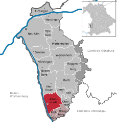
Альтенштадт (Иллер)
Hiking in Альтенштадт (Иллер)
Altenstadt, located in Swabia, Germany, is an excellent destination for hiking enthusiasts, offering a variety of trails that cater to different experience levels. The region is known for its picturesque landscapes, including gentle hills, lush forests, and scenic views that reveal the charm of the Swabian countryside....
- Страна:
- Почтовый код: 89281
- Телефонный код: 08337
- Код автомобильного номера: NU
- Координаты: 48° 9' 37" N, 10° 6' 52" E
- GPS треки (wikiloc): [Ссылка]
- Высота над уровнем моря: 528 м m
- Площадь: 31.30 кв.км
- Население: 4208
- Веб сайт: [Ссылка]


Иллертиссен
Hiking in Иллертиссен
Illertissen, located in the Bavarian region of Germany, offers a variety of scenic hiking opportunities that are perfect for both beginners and experienced hikers. Here are some highlights and tips for hiking in and around Illertissen:...
- Страна:
- Почтовый код: 89257
- Телефонный код: 07303
- Координаты: 48° 13' 0" N, 10° 5' 0" E
- GPS треки (wikiloc): [Ссылка]
- Высота над уровнем моря: 513 м m
- Площадь: 36.45 кв.км
- Население: 16694
- Веб сайт: [Ссылка]

Бальцхайм
Hiking in Бальцхайм
Balzheim is a small village located in the southern part of Germany, not far from the city of Ulm in the state of Baden-Württemberg. While it may not be a widely recognized hiking destination, the surrounding region offers access to picturesque landscapes and opportunities for various outdoor activities....
- Страна:
- Почтовый код: 88481
- Телефонный код: 07347
- Код автомобильного номера: UL
- Координаты: 48° 10' 17" N, 10° 4' 38" E
- GPS треки (wikiloc): [Ссылка]
- Высота над уровнем моря: 519 м m
- Площадь: 17.58 кв.км
- Население: 2046
- Веб сайт: [Ссылка]


Иллерриден
Hiking in Иллерриден
Illerrieden is a charming village located in Bavaria, Germany, near the Iller River. The region offers a variety of hiking opportunities that can cater to different skill levels and preferences. Here are some points to consider if you're planning a hiking trip in Illerrieden:...
- Страна:
- Почтовый код: 89186
- Телефонный код: 07306
- Код автомобильного номера: UL
- Координаты: 48° 16' 13" N, 10° 3' 6" E
- GPS треки (wikiloc): [Ссылка]
- Высота над уровнем моря: 500 м m
- Площадь: 18.17 кв.км
- Население: 3278
- Веб сайт: [Ссылка]


Белленберг
Hiking in Белленберг
Bellenberg is a quaint village in southern Germany, located near the city of Ulm in the state of Baden-Württemberg. Although not widely known as a hiking destination, it can serve as a good base for exploring the scenic trails in the surrounding region. Here are some key points to consider if you're interested in hiking in and around Bellenberg:...
- Страна:
- Почтовый код: 89287
- Телефонный код: 07306
- Код автомобильного номера: NU
- Координаты: 48° 15' 0" N, 10° 5' 0" E
- GPS треки (wikiloc): [Ссылка]
- Высота над уровнем моря: 504 м m
- Площадь: 5.07 кв.км
- Население: 3744
- Веб сайт: [Ссылка]

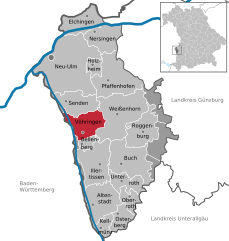
Фёринген
Hiking in Фёринген
Vöhringen is a charming municipality located in Bavaria, Germany, offering various outdoor activities, including hiking. The region is characterized by its beautiful landscapes, including rolling hills, forests, and nearby rivers. Here are some highlights for hiking in and around Vöhringen:...
- Страна:
- Почтовый код: 89269
- Телефонный код: 07306
- Код автомобильного номера: NU
- Координаты: 48° 17' 0" N, 10° 5' 0" E
- GPS треки (wikiloc): [Ссылка]
- Высота над уровнем моря: 499 м m
- Площадь: 23.63 кв.км
- Население: 12168
- Веб сайт: [Ссылка]