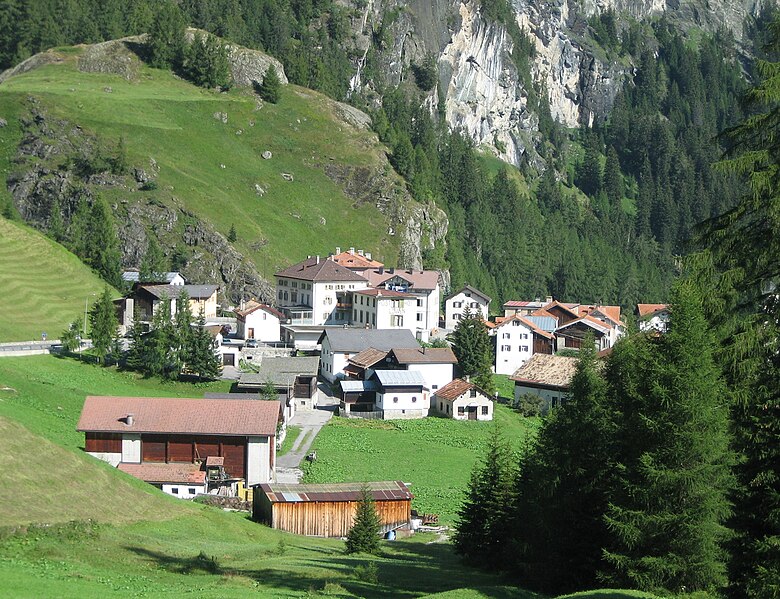
Аверс (Avers, Avers)

 Hiking in Аверс
Avers is a beautiful valley located in the Graubünden canton of Switzerland, known for its stunning landscapes, biodiversity, and wide range of hiking opportunities. Here are some highlights and considerations for hiking in the Avers area:
Scenic Trails
- Avers-Cresta: This trail offers breathtaking views of the surrounding mountains. The path winds through alpine meadows and dense forests, making it perfect for nature lovers.
- Valle di Avers: A scenic hike through the valley provides opportunities to see local wildlife and enjoy the serene environment.
- Piz Avers: For the more adventurous, hiking to Piz Avers offers a challenging trek with rewarding panoramic views at the summit.
Wildlife and Flora
- Avers is rich in biodiversity, and while hiking, you might encounter various flora and fauna, including wildflowers and possibly ibex or chamois. It's a great spot for birdwatching as well.
Best Time to Hike
- The best time for hiking in Avers is late spring to early autumn (June to September) when the trails are snow-free, and the weather is typically mild.
Hiking Preparedness
- Equipment: Wear sturdy hiking boots, bring plenty of water, and pack snacks. A map or GPS device is also recommended.
- Weather: Be prepared for sudden weather changes. Always check the forecast before heading out.
- Difficulty Levels: Trails vary in difficulty, ranging from easy walks to strenuous climbs. Make sure to choose a trail that matches your ability level.
Local Culture and Accommodations
- Avers has charming villages, and you'll find local hospitality in guesthouses and inns. Consider staying overnight to experience the tranquility of the area fully.
Safety Tips
- Always inform someone about your hiking plans, especially for remote areas.
- Hike with a buddy whenever possible, and keep an eye on trail markers to stay on course.
Overall, hiking in Avers offers a perfect blend of natural beauty, tranquility, and adventure, making it a worthwhile destination for both novice and experienced hikers.
- Страна:

- Почтовый код: 7447
- Телефонный код: 081
- Код автомобильного номера: GR
- Координаты: 46° 28' 26" N, 9° 30' 49" E


- GPS треки (wikiloc): [Ссылка]
- Высота над уровнем моря: 1960 м m
- Площадь: 93.12 кв.км
- Население: 169
- Веб сайт: http://www.avers.ch
- Википедия русская: wiki(ru)
- Википедия английская: wiki(en)
- Википедия национальная: wiki(de)
- Хранилище Wikidata: Wikidata: Q69196
- Катеория в википедии: [Ссылка]
- код Freebase: [/m/0gnqlx]
- код GeoNames: Альт: [7285127]
- код VIAF: Альт: [247227874]
- ID отношения в OpenStreetMap: [1684043]
- идентификатор HDS: [1495]
- код швейцарского муниципалитета: [3681]
Граничит с регионами:
Пьюро
- коммуна Италии
Hiking in Пьюро
Piuro is a picturesque village located in the Lombardy region of northern Italy, nestled in the Seriana Valley and close to the border with Switzerland. The area is known for its stunning natural beauty, making it a great destination for hiking enthusiasts. Here are some highlights about hiking in Piuro:...
- Страна:

- Почтовый код: 23020
- Телефонный код: 0343
- Код автомобильного номера: SO
- Координаты: 46° 19' 51" N, 9° 25' 18" E
- GPS треки (wikiloc): [Ссылка]
- Высота над уровнем моря: 382 м m
- Площадь: 84.25 кв.км
- Население: 1932
- Веб сайт: [Ссылка]

Мулегнс
Hiking in Мулегнс
Mulegns, a picturesque village nestled in the Swiss Alps, offers fantastic hiking opportunities for outdoor enthusiasts. It is known for its stunning alpine scenery, lush meadows, and well-marked trails suitable for various skill levels. Here are some highlights of hiking in Mulegns:...
- Страна:
- Почтовый код: 7455
- Телефонный код: 081
- Код автомобильного номера: GR
- Координаты: 46° 30' 16" N, 9° 34' 46" E
- GPS треки (wikiloc): [Ссылка]
- Высота над уровнем моря: 1952 м m
- Площадь: 33.79 кв.км


Бивио
Hiking in Бивио
Bivio is a charming village located in the Swiss Alps, known for its stunning natural landscapes and excellent hiking opportunities. Situated at the junction of several hiking trails, Bivio serves as a gateway to the surrounding mountains and valleys, making it a popular destination for outdoor enthusiasts....
- Страна:
- Почтовый код: 7457
- Телефонный код: 081
- Код автомобильного номера: GR
- Координаты: 46° 28' 11" N, 9° 39' 4" E
- GPS треки (wikiloc): [Ссылка]
- Высота над уровнем моря: 1769 м m
- Площадь: 76.73 кв.км
- Веб сайт: [Ссылка]


Bregaglia
Hiking in Bregaglia
Bregaglia, a stunning valley in the southern part of Switzerland, is known for its picturesque landscapes, charming villages, and a wide range of hiking opportunities. Here are some highlights about hiking in the region:...
- Страна:
- Почтовый код: 7603, 7605, 7606, 7608, 7610, 7516
- Телефонный код: 081
- Код автомобильного номера: GR
- Координаты: 46° 20' 0" N, 9° 35' 0" E
- GPS треки (wikiloc): [Ссылка]
- Высота над уровнем моря: 994 м m
- Площадь: 251.45 кв.км
- Население: 1531
- Веб сайт: [Ссылка]