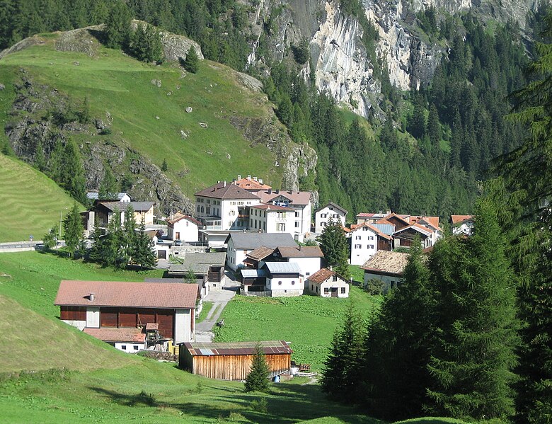
Бивио (Bivio, Bivio)

 Hiking in Бивио
Bivio is a charming village located in the Swiss Alps, known for its stunning natural landscapes and excellent hiking opportunities. Situated at the junction of several hiking trails, Bivio serves as a gateway to the surrounding mountains and valleys, making it a popular destination for outdoor enthusiasts.
Hiking Trails:
-
Piz Bivio: One of the most popular hikes from Bivio is to Piz Bivio, which offers breathtaking panoramic views. The trailhead can be accessed from the village, and the hike typically takes a few hours. The ascent can be challenging, but the scenic rewards are well worth the effort.
-
Bivio to Lago di Bivio: This relatively easier hike leads you to the beautiful Lago di Bivio. It's a great option for families and those looking for a more leisurely walk. The lake is picturesque and a great spot for a picnic or simply enjoying nature.
-
Valley Hikes: There are various trails that take you through the valleys surrounding Bivio, such as the Surses Valley. These hikes often pass through meadows and forests, providing a more gentle terrain and the chance to observe local flora and fauna.
-
Multi-day Hikes: For the more adventurous, Bivio can be incorporated into multi-day trekking routes that connect with other alpine villages and remote areas, ideal for those looking for a deeper exploration of the Swiss Alps.
Tips for Hiking in Bivio:
- Season: The best months for hiking are from late spring to early autumn (May to September), as trails are generally well-maintained and accessible.
- Gear: Ensure you have appropriate hiking gear including sturdy boots, weather-appropriate clothing, a good backpack, plenty of water, and snacks.
- Navigation: While many trails are well-marked, having a map or GPS can be beneficial, especially if you plan on exploring less-traveled routes.
- Local Wildlife: Be mindful of wildlife and practice Leave No Trace principles to preserve the natural beauty of the area.
- Weather: Always check the weather conditions before heading out, as mountain weather can change rapidly.
Bivio not only provides a great base for hiking but also allows for a unique cultural experience in the Swiss Alps, with opportunities to enjoy local cuisine and hospitality. Enjoy your hiking adventure in Bivio!
- Страна:

- Почтовый код: 7457
- Телефонный код: 081
- Код автомобильного номера: GR
- Координаты: 46° 28' 11" N, 9° 39' 4" E


- GPS треки (wikiloc): [Ссылка]
- Высота над уровнем моря: 1769 м m
- Площадь: 76.73 кв.км
- Веб сайт: http://www.bivio.ch
- Википедия русская: wiki(ru)
- Википедия английская: wiki(en)
- Википедия национальная: wiki(de)
- Хранилище Wikidata: Wikidata: Q68332
- Катеория в википедии: [Ссылка]
- код Freebase: [/m/0kw6jm]
- код GeoNames: Альт: [2661484]
- код BNF: [11970296q]
- код VIAF: Альт: [151333119]
- код GND: Альт: [4222568-1]
- код LCNAF: Альт: [n85101404]
- идентификатор HDS: [1422]
- код швейцарского муниципалитета: [3531]
Граничит с регионами:


Сур
Hiking in Сур
Sur is a charming village located in the Swiss canton of Grisons (Graubünden) and offers impressive hiking opportunities, primarily for those who love the beautiful landscapes of the Swiss Alps. Here’s an overview of what you can expect:...
- Страна:
- Почтовый код: 7456
- Телефонный код: 081
- Код автомобильного номера: GR
- Координаты: 46° 30' 59" N, 9° 36' 59" E
- GPS треки (wikiloc): [Ссылка]
- Высота над уровнем моря: 1530 м m
- Площадь: 23.22 кв.км
- Веб сайт: [Ссылка]


Марморера
Hiking in Марморера
Marmorera is a picturesque area located in the canton of Graubünden in Switzerland, known for its stunning landscapes, diverse hiking trails, and tranquil atmosphere. Here are some key points to consider if you're planning to hike in Marmorera:...
- Страна:
- Почтовый код: 7456
- Телефонный код: 081
- Код автомобильного номера: GR
- Координаты: 46° 29' 59" N, 9° 39' 0" E
- GPS треки (wikiloc): [Ссылка]
- Высота над уровнем моря: 1720 м m
- Площадь: 18.90 кв.км
- Веб сайт: [Ссылка]


Сильваплана
Hiking in Сильваплана
Silvaplana, located in the Engadin valley in Switzerland, is a beautiful destination for hiking enthusiasts. Nestled between the stunning lakes of Silvaplana and Sils, and surrounded by imposing mountain scenery, it offers a variety of hiking trails for all levels of experience....
- Страна:
- Почтовый код: 7513
- Телефонный код: 081
- Код автомобильного номера: GR
- Координаты: 46° 27' 29" N, 9° 47' 43" E
- GPS треки (wikiloc): [Ссылка]
- Высота над уровнем моря: 1817 м m
- Площадь: 44.77 кв.км
- Население: 1117
- Веб сайт: [Ссылка]

Мулегнс
Hiking in Мулегнс
Mulegns, a picturesque village nestled in the Swiss Alps, offers fantastic hiking opportunities for outdoor enthusiasts. It is known for its stunning alpine scenery, lush meadows, and well-marked trails suitable for various skill levels. Here are some highlights of hiking in Mulegns:...
- Страна:
- Почтовый код: 7455
- Телефонный код: 081
- Код автомобильного номера: GR
- Координаты: 46° 30' 16" N, 9° 34' 46" E
- GPS треки (wikiloc): [Ссылка]
- Высота над уровнем моря: 1952 м m
- Площадь: 33.79 кв.км


Аверс
Hiking in Аверс
Avers is a beautiful valley located in the Graubünden canton of Switzerland, known for its stunning landscapes, biodiversity, and wide range of hiking opportunities. Here are some highlights and considerations for hiking in the Avers area:...
- Страна:
- Почтовый код: 7447
- Телефонный код: 081
- Код автомобильного номера: GR
- Координаты: 46° 28' 26" N, 9° 30' 49" E
- GPS треки (wikiloc): [Ссылка]
- Высота над уровнем моря: 1960 м m
- Площадь: 93.12 кв.км
- Население: 169
- Веб сайт: [Ссылка]


Bregaglia
Hiking in Bregaglia
Bregaglia, a stunning valley in the southern part of Switzerland, is known for its picturesque landscapes, charming villages, and a wide range of hiking opportunities. Here are some highlights about hiking in the region:...
- Страна:
- Почтовый код: 7603, 7605, 7606, 7608, 7610, 7516
- Телефонный код: 081
- Код автомобильного номера: GR
- Координаты: 46° 20' 0" N, 9° 35' 0" E
- GPS треки (wikiloc): [Ссылка]
- Высота над уровнем моря: 994 м m
- Площадь: 251.45 кв.км
- Население: 1531
- Веб сайт: [Ссылка]