Бад-Вильдбад (Bad Wildbad VVG, Vereinbarte Verwaltungsgemeinschaft Bad Wildbad)
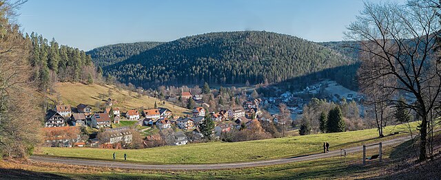
 Hiking in Бад-Вильдбад
Bad Wildbad, located in the Black Forest region of Germany, is a fantastic destination for hiking enthusiasts. The area offers a variety of trails that cater to different skill levels, from leisurely walks to more challenging hikes. Here are some highlights of hiking in Bad Wildbad:
-
Scenic Trails: The trails around Bad Wildbad offer stunning views of the Black Forest's lush landscapes, dense forests, and rolling hills. You can hike along the Enz River or explore the scenic mountain paths.
-
Themed Trails: One popular option is the "Panoramaweg," a circular trail that provides breathtaking views and informative signage about the local flora and fauna. There are also thematic paths like the "Barfussweg" (barefoot path) for a unique sensory experience.
-
Difficulty Levels: The hiking trails vary in difficulty. Some are suitable for families and beginners, while others are more strenuous, involving steeper climbs and rocky terrains. Be sure to choose a trail that matches your fitness level.
-
Natural Attractions: Along the routes, hikers can discover natural attractions such as waterfalls, scenic viewpoints, and lookout towers. The area around Bad Wildbad is known for its rich biodiversity and picturesque landscapes.
-
Well-Marked Trails: The hiking trails are well-marked with signage, making it easy to navigate the routes. Maps and information boards are available at key points to help you plan your hike.
-
Accessibility: Bad Wildbad is accessible by public transportation, and many trailheads can be reached easily from the town center. This makes it convenient for both short and longer hikes.
-
Local Amenities: After a day of hiking, you can enjoy local hospitality, with plenty of restaurants, cafes, and wellness facilities in Bad Wildbad, including thermal baths to relax your muscles.
-
Seasonal Hiking: Each season brings a different experience in Bad Wildbad. Spring and summer are perfect for wildflower blooms, autumn offers vibrant foliage, and winter can provide opportunities for snowshoeing or winter hiking.
Before setting out, ensure you're adequately prepared with suitable footwear, enough water, snacks, and a map or GPS device. Always check the weather conditions and trail specifics, as they can change rapidly in mountainous regions. Enjoy your hiking adventure in Bad Wildbad!
- Страна:

- Хранилище Wikidata: Wikidata: Q9378502
- ID отношения в OpenStreetMap: [2952606]
- код региона Германии: 082355008
Включает регионы:

Энцклёстерле
Hiking in Энцклёстерле
Enzklösterle is a picturesque village located in the Black Forest region of Germany, particularly known for its beautiful natural landscapes, lush forests, and numerous hiking trails. Here are some highlights if you’re considering hiking in Enzklösterle:...
- Страна:
- Почтовый код: 75337
- Телефонный код: 07085
- Код автомобильного номера: CW
- Координаты: 48° 40' 5" N, 8° 28' 17" E


- GPS треки (wikiloc): [Ссылка]
- Высота над уровнем моря: 590 м m
- Площадь: 20.20 кв.км
- Население: 1218
- Веб сайт: [Ссылка]


Бад-Вильдбад
- город в земле Баден-Вюртемберг, Германия
Hiking in Бад-Вильдбад
Bad Wildbad is a charming spa town located in the northern Black Forest region of Germany, known for its beautiful landscapes and numerous hiking trails. The area offers a variety of hiking opportunities suitable for different skill levels, from leisurely walks to more challenging trails....
- Страна:
- Почтовый код: 75323
- Телефонный код: 07081
- Код автомобильного номера: CW
- Координаты: 48° 45' 1" N, 8° 33' 2" E
- GPS треки (wikiloc): [Ссылка]
- Высота над уровнем моря: 425 м m
- Площадь: 105.27 кв.км
- Население: 9876
- Веб сайт: [Ссылка]


Хёфен-на-Энце
Hiking in Хёфен-на-Энце
Höfen an der Enz is a charming village located in the northern part of the Black Forest region in Germany. It is known for its beautiful natural surroundings, making it a great destination for hiking enthusiasts. Here are some highlights about hiking in and around Höfen an der Enz:...
- Страна:
- Почтовый код: 75339
- Телефонный код: 07081
- Код автомобильного номера: CW
- Координаты: 48° 48' 12" N, 8° 35' 3" E
- GPS треки (wikiloc): [Ссылка]
- Высота над уровнем моря: 366 м m
- Площадь: 9.08 кв.км
- Население: 1780
- Веб сайт: [Ссылка]