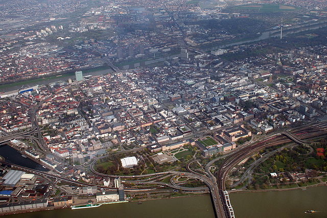
Административный округ Карлсруэ (Karlsruhe Government Region, Regierungsbezirk Karlsruhe)

- административная единица в Баден-Вюртемберге, Германия
 Hiking in Административный округ Карлсруэ
Karlsruhe, located in the southwest of Germany, is a great base for hiking enthusiasts. The region offers a mix of urban and natural landscapes, with easy access to nearby hills and forests. Here are some key highlights for hiking in the Karlsruhe area:
1.
Just a short drive from Karlsruhe, the Black Forest offers a wealth of hiking opportunities. Here, you'll find well-marked trails that wind through dense forests, past picturesque waterfalls, and up to stunning viewpoints. Popular trails include:
- The Westweg: This is a long-distance trail that runs the length of the Black Forest, with sections accessible from Karlsruhe.
- Mummelsee Loop: A scenic trail around Mummelsee lake, offering beautiful views and a mix of easy-going terrain.
2.
To the south of Karlsruhe, the Kaiserstuhl region is known for its vineyards and volcanic hills. Hikes here often provide stunning views over the Rhine Valley and are marked by charming wine villages. The Kaiserstuhl Wine Trail is popular, allowing you to enjoy both nature and local wines.
3.
Closer to the city, the Oberwald and Hardtwald forests provide an excellent escape into nature with numerous well-maintained trails. These trails are suitable for day hikes and are relatively easy, making them perfect for families or beginners.
4.
Located in the nearby town of Durlach, Turmberg is a local favorite. The hike up to the Turmberg, where you can find a lookout tower, offers great views of Karlsruhe and the surrounding region. The area is also popular for picnics and leisurely walks.
5.
- Many hiking trails in the region are well-marked and mapped, making navigation easy.
- Be sure to wear appropriate footwear and carry enough water, especially in warmer months.
- The best time for hiking in the Karlsruhe area is spring through autumn when the weather is mild and the scenery is vibrant.
- For those interested in culture, consider hiking to local sights and landmarks, as many trails intertwine with historical sites.
Conclusion
Karlsruhe and its surroundings provide an excellent variety of hiking experiences, from scenic forest walks to panoramic mountain trails. Whether you're a seasoned hiker or just looking for a peaceful day out in nature, there are plenty of options to explore. Enjoy your hiking adventure!
- Страна:

- Столица: Карлсруэ
- Координаты: 49° 0' 0" N, 8° 30' 0" E


- GPS треки (wikiloc): [Ссылка]
- Высота над уровнем моря: 120 м m
- Площадь: 6919 кв.км
- Веб сайт: http://www.rp-karlsruhe.de/
- Википедия русская: wiki(ru)
- Википедия английская: wiki(en)
- Википедия национальная: wiki(de)
- Хранилище Wikidata: Wikidata: Q8165
- Катеория в википедии: [Ссылка]
- код Freebase: [/m/01bp7r]
- код GeoNames: Альт: [6555606]
- код VIAF: Альт: [157208228]
- ID отношения в OpenStreetMap: [22027]
- код GND: Альт: [4029716-0]
- код LCNAF: Альт: [n88080952]
- код TGN: [7075018]
- код NUTS: [DE12]
- FAST ID: [1334602]
Включает регионы:


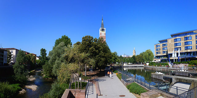
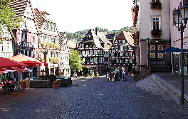
Карлсруэ
- город в земле Баден-Вюртемберг, Германия
Hiking in Карлсруэ
Karlsruhe, located in the southwestern part of Germany, is not only an urban center but also a great starting point for various hiking adventures. While the city itself has several parks and walking paths, the surrounding regions offer beautiful trails for all levels of hikers. Here are some key areas and trails to consider:...
- Страна:
- Почтовый код: 76228; 76227; 76189; 76187; 76185; 76199; 76149; 76139; 76135; 76133; 76137; 76131; 76229
- Телефонный код: 721
- Код автомобильного номера: KA
- Координаты: 49° 1' 0" N, 8° 24' 0" E
- GPS треки (wikiloc): [Ссылка]
- Высота над уровнем моря: 118 м m
- Площадь: 173.42 кв.км
- Население: 309999
- Веб сайт: [Ссылка]

Мангейм
- город в земле Баден-Вюртемберг, Германия
Hiking in Мангейм
Mannheim, located in southwestern Germany, is not typically known as a hiking destination compared to some of the more mountainous regions of the country. However, it does offer some pleasant walking and hiking opportunities, particularly along the Rhine and Neckar rivers. Here are some options for hiking in and around Mannheim:...
- Страна:
- Почтовый код: 68309; 68307; 68305; 68259; 68239; 68229; 68219; 68199; 68169; 68167; 68165; 68163; 68161; 68159
- Телефонный код: 0621
- Код автомобильного номера: MA
- Координаты: 49° 29' 1" N, 8° 27' 47" E
- GPS треки (wikiloc): [Ссылка]
- Высота над уровнем моря: 97 м m
- Площадь: 144.97 кв.км
- Население: 304781
- Веб сайт: [Ссылка]


Гейдельберг
- город в земле Баден-Вюртемберг, Германия
Hiking in Гейдельберг
Heidelberg, located in the Baden-Württemberg region of Germany, is not only famous for its historic university and picturesque old town but also offers a variety of hiking opportunities for all levels of experience. The surrounding Odenwald Forest and the landscape along the Neckar River provide numerous scenic trails....
- Страна:
- Почтовый код: 69001
- Телефонный код: 6202; 6221
- Код автомобильного номера: HD
- Координаты: 49° 24' 44" N, 8° 42' 36" E
- GPS треки (wikiloc): [Ссылка]
- Высота над уровнем моря: 114 м m
- Площадь: 108.89 кв.км
- Население: 159914
- Веб сайт: [Ссылка]

Пфорцхайм
- город в земле Баден-Вюртемберг, Германия
Hiking in Пфорцхайм
Pforzheim, located in the northern part of the Black Forest in Germany, offers a variety of hiking opportunities that cater to different skill levels. The region is characterized by its lush forests, picturesque landscapes, and scenic trails....
- Страна:
- Почтовый код: 75172–75181
- Телефонный код: 07231; 07234
- Код автомобильного номера: PF
- Координаты: 48° 54' 0" N, 8° 43' 0" E
- GPS треки (wikiloc): [Ссылка]
- Высота над уровнем моря: 273 м m
- Площадь: 98.07 кв.км
- Население: 123493
- Веб сайт: [Ссылка]


Баден-Баден
- город на земле Баден-Вюртемберг, Германия
Hiking in Баден-Баден
Baden-Baden, located in the Black Forest region of Germany, is a popular hiking destination known for its stunning landscapes, well-marked trails, and temperate climate. Here are some highlights and tips for hiking in and around Baden-Baden:...
- Страна:
- Почтовый код: 76534; 76533; 76532; 76531; 76530
- Телефонный код: 07223; 07221
- Код автомобильного номера: BAD
- Координаты: 48° 45' 43" N, 8° 14' 27" E
- GPS треки (wikiloc): [Ссылка]
- Высота над уровнем моря: 181 м m
- Площадь: 140.21 кв.км
- Население: 54307
- Веб сайт: [Ссылка]


Неккар-Оденвальд
Hiking in Неккар-Оденвальд
Neckar-Odenwald-Kreis, located in the state of Baden-Württemberg, Germany, is a fantastic destination for hiking enthusiasts. The region is characterized by its scenic landscapes, which include dense forests, rolling hills, and the beautiful Neckar River valley. Here are some key points to know about hiking in this area:...
- Страна:
- Столица: Мосбах
- Код автомобильного номера: MOS
- Координаты: 49° 29' 0" N, 9° 17' 0" E
- GPS треки (wikiloc): [Ссылка]
- Высота над уровнем моря: 416 м m
- Площадь: 1126.29 кв.км
- Население: 141847
- Веб сайт: [Ссылка]

Рейн-Неккар
Hiking in Рейн-Неккар
The Rhein-Neckar-Kreis, located in the southwest of Germany, is a fantastic destination for hiking enthusiasts. It's part of the larger Rhein-Neckar Metropolitan Region and boasts diverse landscapes, including rolling hills, dense forests, vineyards, and picturesque villages. Here are some highlights and considerations for hiking in the area:...
- Страна:
- Столица: Гейдельберг
- Код автомобильного номера: HD
- Координаты: 49° 22' 0" N, 8° 44' 0" E
- GPS треки (wikiloc): [Ссылка]
- Высота над уровнем моря: 390 м m
- Веб сайт: [Ссылка]

Карлсруэ
- административный район в Баден-Вюртемберге, Германия
Hiking in Карлсруэ
Karlsruhe, located in the southwest of Germany in the state of Baden-Württemberg, offers a variety of hiking opportunities both in the city and in the surrounding countryside. Here are some key points to consider when hiking in and around Karlsruhe:...
- Страна:
- Столица: Карлсруэ
- Код автомобильного номера: KA
- Координаты: 49° 4' 48" N, 8° 34' 48" E
- GPS треки (wikiloc): [Ссылка]
- Высота над уровнем моря: 118 м m
- Площадь: 1084.95 кв.км
- Население: 435841
- Веб сайт: [Ссылка]


Раштатт
- район в Германии
Hiking in Раштатт
Rastatt district, located in the state of Baden-Württemberg, Germany, offers a variety of hiking opportunities, particularly due to its proximity to the Black Forest and its diverse landscapes. Here are some highlights and tips for hiking in the Rastatt district:...
- Страна:
- Столица: Раштатт
- Код автомобильного номера: RA; BH
- Координаты: 48° 48' 0" N, 8° 16' 12" E
- GPS треки (wikiloc): [Ссылка]
- Высота над уровнем моря: 236 м m
- Площадь: 738.75 кв.км
- Население: 227474
- Веб сайт: [Ссылка]

Энц
Hiking in Энц
Enzkreis, located in Baden-Württemberg, Germany, is a wonderful area for hiking enthusiasts, offering a mix of picturesque landscapes, historic towns, and diverse trail options. Here’s an overview of some aspects to consider when hiking in this region:...
- Страна:
- Столица: Пфорцхайм
- Код автомобильного номера: PF
- Координаты: 48° 54' 0" N, 8° 45' 0" E
- GPS треки (wikiloc): [Ссылка]
- Высота над уровнем моря: 298 м m
- Площадь: 573.69 кв.км
- Веб сайт: [Ссылка]

Кальв
Hiking in Кальв
Calw district, located in the state of Baden-Württemberg, Germany, offers a rich variety of hiking opportunities amidst beautiful natural landscapes. The area is characterized by rolling hills, dense forests, and charming villages, making it a delightful destination for both casual walkers and serious hikers....
- Страна:
- Столица: Кальв
- Код автомобильного номера: CW
- Координаты: 48° 42' 0" N, 8° 44' 24" E
- GPS треки (wikiloc): [Ссылка]
- Высота над уровнем моря: 648 м m
- Площадь: 797.54 кв.км
- Население: 150709
- Веб сайт: [Ссылка]


Фройденштадт
Hiking in Фройденштадт
Freudenstadt, located in the Black Forest region of Germany, offers a wealth of hiking opportunities for outdoor enthusiasts. The district is known for its picturesque landscapes, dense forests, and charming villages, making it an ideal destination for hikers of all levels....
- Страна:
- Столица: Фройденштадт
- Код автомобильного номера: HOR; FDS
- Координаты: 48° 30' 0" N, 8° 25' 12" E
- GPS треки (wikiloc): [Ссылка]
- Высота над уровнем моря: 645 м m
- Площадь: 870.68 кв.км
- Население: 115055
- Веб сайт: [Ссылка]
Граничит с регионами:


Нижняя Франкония
- административный округ Баварии
Hiking in Нижняя Франкония
Lower Franconia, located in the northern part of Bavaria, Germany, is a great destination for hiking enthusiasts. This region is known for its diverse landscapes that range from rolling hills to picturesque vineyards and nature reserves, offering a variety of trails suitable for different skill levels....
- Страна:
- Столица: Вюрцбург
- Координаты: 50° 1' 28" N, 9° 55' 55" E
- GPS треки (wikiloc): [Ссылка]
- Высота над уровнем моря: 289 м m
- Площадь: 8530.99 кв.км
- Население: 1298849
- Веб сайт: [Ссылка]