
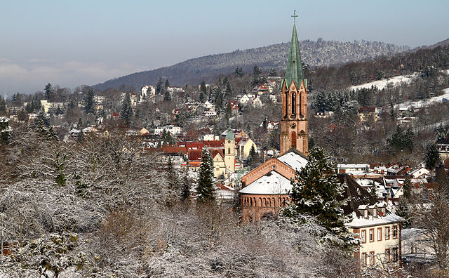
Баден-Баден (Baden-Baden, Baden-Baden)

- город на земле Баден-Вюртемберг, Германия
 Hiking in Баден-Баден
Baden-Baden, located in the Black Forest region of Germany, is a popular hiking destination known for its stunning landscapes, well-marked trails, and temperate climate. Here are some highlights and tips for hiking in and around Baden-Baden:
Scenic Trails
-
Meridianweg: This circular trail offers breathtaking views of the surrounding countryside and is ideal for day hikes. It’s about 8 to 15 kilometers long, depending on the route you choose, featuring beautiful forests, meadows, and scenic overlooks.
-
Lichtenaler Allee: A more relaxed option, this picturesque path runs along the Oos river and through parks. It’s perfect for a leisurely stroll and is wheelchair accessible.
-
Bergwaldweg: This trail is slightly more challenging and leads through beautiful forests with a variety of flora and fauna, offering a chance to learn about the local ecosystem.
-
Panoramaweg: For those looking for panoramic views, the Panoramaweg trail gives hikers a breathtaking vista of the Black Forest and is well worth the effort.
Natural Attractions
- The Black Forest: This vast area offers numerous hiking options, from gentle walks to more strenuous treks. Forested paths, serene lakes, and mountain views abound.
- Castle Ruins: Some trails lead to historic sites, like the Hohenbaden Castle, which offers both a hiking experience and a chance to explore the ruins.
Seasonal Considerations
- Spring and Summer: Ideal for hiking, when the weather is usually mild and the flora is in full bloom. Bring water and sunscreen, as trails can be quite open.
- Fall: The autumn colors make for stunning scenery, but be cautious of muddy trails after rain.
- Winter: Some trails may be suitable for winter hiking, but always check conditions. Snow can make trails challenging.
Tips for Hiking in Baden-Baden
- Trail Markings: Trails are generally well signposted, but it's wise to carry a map or download a hiking app.
- Gear: Good hiking shoes are necessary, especially in more rugged areas. Bring plenty of water and snacks.
- Local Guidance: Consider joining a guided hike or visiting the tourist information center for additional advice and maps.
- Respect Nature: Stick to marked paths, and remember to take your litter with you to preserve the beauty of the environment.
Amenities
Baden-Baden has several charming cafes and restaurants where you can rest after a hike. Additionally, the town is famous for its thermal spas, making it a perfect place to relax and rejuvenate after a day of hiking.
Whether you’re looking for a casual walk through lush landscapes or a vigorous hike with panoramic views, Baden-Baden offers diverse options to satisfy any hiking enthusiast.
- Страна:

- Почтовый код: 76534; 76533; 76532; 76531; 76530
- Телефонный код: 07223; 07221
- Код автомобильного номера: BAD
- Координаты: 48° 45' 43" N, 8° 14' 27" E


- GPS треки (wikiloc): [Ссылка]
- Высота над уровнем моря: 181 м m
- Площадь: 140.21 кв.км
- Население: 54307
- Веб сайт: https://www.baden-baden.de/
- Википедия русская: wiki(ru)
- Википедия английская: wiki(en)
- Википедия национальная: wiki(de)
- Хранилище Wikidata: Wikidata: Q4100
- Катеория в википедии: [Ссылка]
- Карты в википедии: [Ссылка]
- код Freebase: [/m/0m38x]
- код GeoNames: Альт: [2953504]
- код BNF: [16067825g]
- код VIAF: Альт: [247457781]
- ID отношения в OpenStreetMap: [62340]
- код GND: Альт: [4004169-4]
- идентификатор местоположения ArchINFORM: [127]
- код LCNAF: Альт: [n50057123]
- место в MusicBrainz: [d43989dc-c7b1-457c-bf33-c91c7cf20c74]
- код темы Quora: [Baden-Baden]
- код SUDOC: [072320168]
- код в энциклопедии «Британника онлайн»: [place/Baden-Baden-Germany]
- код места в Facebook: [114925731853927]
- код в Большой российской энциклопедии онлайн: [1845148]
- код ISNI: Альт: [0000 0004 0399 8638]
- dmoz: Альт: [Regional/Europe/Germany/States/Baden-Württemberg/Localities/Baden-Baden/]
- код NUTS: [DE121]
- идентификатор Ringgold: [195962]
- идентификатор муниципалитетов в Германии: 08211000
- код US National Archives: 10044733
- код района Германии: 08211
Включает регионы:

Ebersteinburg
Hiking in Ebersteinburg
Ebersteinburg, located in the Black Forest region of Germany, offers a variety of hiking opportunities characterized by scenic views, lush forests, and charming landscapes. Here are some key aspects to consider while hiking in Ebersteinburg:...
- Страна:
- Почтовый код: 76530
- Телефонный код: 07221
- Координаты: 48° 46' 48" N, 8° 16' 12" E
- GPS треки (wikiloc): [Ссылка]
- Высота над уровнем моря: 425 м m
- Площадь: 5.2 кв.км
- Население: 1216

Haueneberstein
Hiking in Haueneberstein
Haueneberstein, a district in the town of Rastatt in Baden-Württemberg, Germany, offers scenic hiking opportunities amid beautiful natural landscapes. Situated near the northern edge of the Black Forest, this area is characterized by lush forests, rolling hills, and picturesque views....
- Страна:
- Почтовый код: 76532
- Телефонный код: 07221
- Координаты: 48° 48' 22" N, 8° 13' 20" E
- GPS треки (wikiloc): [Ссылка]
- Высота над уровнем моря: 130 м m
- Площадь: 9 кв.км

Neuweier
Hiking in Neuweier
Neuweier is a picturesque village located in the Baden-Württemberg region of Germany, nestled in the foothills of the Black Forest. Known for its beautiful landscapes, vineyards, and gentle hills, it offers a variety of hiking opportunities that cater to different skill levels....
- Страна:
- Почтовый код: 76534
- Телефонный код: 07223
- Координаты: 48° 43' 17" N, 8° 11' 1" E
- GPS треки (wikiloc): [Ссылка]
- Высота над уровнем моря: 182 м m
- Площадь: 6.06 кв.км

Oos
Hiking in Oos
Hiking in Oos, a district in Baden-Baden, offers a wonderful mix of natural beauty, serene landscapes, and accessible trails. The region is characterized by its rolling hills, forests, and scenic views of the surrounding Black Forest. Here are some highlights and tips for hiking in this area:...
- Страна:
- Почтовый код: 76532
- Телефонный код: 07221
- Координаты: 48° 47' 18" N, 8° 11' 33" E
- GPS треки (wikiloc): [Ссылка]
- Высота над уровнем моря: 126 м m
- Площадь: 12.97 кв.км
Sandweier
Hiking in Sandweier
Sandweier is a picturesque village located near the city of Baden-Baden in Germany, known for its stunning landscapes and nature. Hiking in and around Sandweier offers a variety of trails suitable for different skill levels, allowing hikers to experience the beauty of the Black Forest region....
- Страна:
- Почтовый код: 76532
- Телефонный код: 07221
- Координаты: 48° 48' 32" N, 8° 11' 43" E
- GPS треки (wikiloc): [Ссылка]
- Высота над уровнем моря: 124 м m
- Площадь: 12.8 кв.км

Штайнбах
Hiking in Штайнбах
Steinbach, located near Baden-Baden in Germany, offers beautiful hiking opportunities that blend nature with stunning views. The area is characterized by its lush landscapes, rolling hills, and a diverse range of flora and fauna....
- Страна:
- Почтовый код: 76534
- Телефонный код: 07223
- Координаты: 48° 43' 42" N, 8° 9' 39" E
- GPS треки (wikiloc): [Ссылка]
- Высота над уровнем моря: 142 м m
- Площадь: 11.81 кв.км

Varnhalt
Hiking in Varnhalt
Varnhalt is a picturesque village located in the Baden-Württemberg region of Germany, near the famous wine-producing area of Baden and not far from the Black Forest. It offers a variety of hiking opportunities that cater to different skill levels and interests. Here are a few highlights of hiking in and around Varnhalt:...
- Страна:
- Почтовый код: 76534
- Телефонный код: 07223
- Координаты: 48° 44' 5" N, 8° 10' 48" E
- GPS треки (wikiloc): [Ссылка]
- Высота над уровнем моря: 191 м m
- Площадь: 4.16 кв.км

Balg
Hiking in Balg
Balg is a picturesque district located near Baden-Baden, Germany, known for its beautiful natural landscapes and outdoor activities, including hiking. The area is part of the Black Forest region, which is famous for its dense forests, rolling hills, and stunning vistas. Here are some key points to consider when hiking in Balg and its surroundings:...
- Страна:
- Почтовый код: 76532
- Телефонный код: 07221
- Координаты: 48° 47' 20" N, 8° 13' 34" E
- GPS треки (wikiloc): [Ссылка]
- Высота над уровнем моря: 205.5 м m
- Площадь: 3.25 кв.км
Lichtental
Hiking in Lichtental
Lichtenthal, a district of Baden-Baden in Germany, is known for its beautiful natural surroundings and offers several hiking opportunities for outdoor enthusiasts. Here are some highlights for hiking in the area:...
- Страна:
- Почтовый код: 76534
- Телефонный код: 07221
- Координаты: 48° 44' 38" N, 8° 15' 39" E
- GPS треки (wikiloc): [Ссылка]
- Высота над уровнем моря: 187 м m
- Площадь: 10.1 кв.км
Граничит с регионами:


Раштатт
- район в Германии
Hiking in Раштатт
Rastatt district, located in the state of Baden-Württemberg, Germany, offers a variety of hiking opportunities, particularly due to its proximity to the Black Forest and its diverse landscapes. Here are some highlights and tips for hiking in the Rastatt district:...
- Страна:
- Столица: Раштатт
- Код автомобильного номера: RA; BH
- Координаты: 48° 48' 0" N, 8° 16' 12" E
- GPS треки (wikiloc): [Ссылка]
- Высота над уровнем моря: 236 м m
- Площадь: 738.75 кв.км
- Население: 227474
- Веб сайт: [Ссылка]