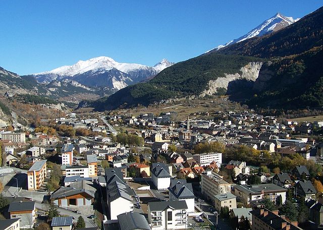
Бардонеккия (Bardonecchia, Bardonecchia)

- коммуна Италии
 Hiking in Бардонеккия
Bardonecchia, located in the Susa Valley of the Piedmont region of Italy, is a popular destination for hiking enthusiasts, offering a range of trails that cater to different skill levels and preferences. The area is known for its stunning alpine scenery, diverse ecosystems, and rich cultural heritage.
Hiking Trails
-
Sentiero dei Fiori: This is a relatively easy trail perfect for families and beginners. It offers beautiful views of wildflowers in the summer and leads to scenic viewpoints.
-
Colomion to the Rocce Nere: This moderate trail involves a steep ascent but rewards hikers with panoramic vistas of the surrounding mountains. It's advisable to wear sturdy hiking boots for this trek.
-
The Alta Via dei Forti: This long-distance route runs along several historic fortifications from the 19th century. It's a more challenging hike, stretching over multiple days, and requires good preparation and fitness.
-
Lago delle Fonti: A beautiful destination for a day hike, this trail is accessible and takes you to a picturesque lake surrounded by mountains, ideal for picnics and photography.
Best Season to Hike
The best time for hiking in Bardonecchia is typically from late spring to early autumn (May to September) when the weather is generally mild, and the trails are free of snow. However, always check weather conditions and trail conditions, as alpine weather can change rapidly.
Preparation Tips
- Gear: Wear appropriate hiking boots, carry a good backpack, and ensure you have sufficient water, snacks, and sun protection.
- Navigation: Consider having a map or a GPS device, especially for longer or more remote trails.
- Local Guidelines: Always follow local regulations and guidelines for safety, and be mindful of wildlife and the environment.
Getting There
Bardonecchia is accessible by train or car from major cities like Turin. The town has a number of facilities, including restaurants and accommodation options, making it a convenient base for hiking.
Overall, hiking in Bardonecchia offers a fantastic opportunity to explore the majestic Alps, enjoy nature, and experience the cultural aspects of this beautiful region.
- Страна:

- Почтовый код: 10052
- Телефонный код: 0122
- Код автомобильного номера: TO
- Координаты: 45° 4' 42" N, 6° 42' 14" E


- GPS треки (wikiloc): [Ссылка]
- Высота над уровнем моря: 1312 м m
- Площадь: 132.2 кв.км
- Население: 3155
- Веб сайт: http://www.comune.bardonecchia.to.it/
- Википедия русская: wiki(ru)
- Википедия английская: wiki(en)
- Википедия национальная: wiki(it)
- Хранилище Wikidata: Wikidata: Q9039
- Катеория в википедии: [Ссылка]
- код Freebase: [/m/0b4_6t]
- код GeoNames: Альт: [6539513]
- код VIAF: Альт: [167322264]
- ID отношения в OpenStreetMap: [44251]
- код GND: Альт: [4428396-9]
- код тезауруса PACTOLS: [pcrtknLHosJXwr]
- код TGN: [1043412]
- UN/LOCODE: [ITBD2]
- код ISTAT: 001022
- кадастровый код Италии: A651
Граничит с регионами:


Bramans
- коммуна во Франции
Hiking in Bramans
Bramans is a charming village located in the Savoie region of the French Alps, known for its stunning natural landscapes and outdoor activities, including hiking. The area offers a variety of hiking trails that cater to different skill levels, making it a great destination for both beginner and experienced hikers....
- Страна:

- Почтовый код: 73500
- Координаты: 45° 13' 25" N, 6° 46' 34" E
- GPS треки (wikiloc): [Ссылка]
- Площадь: 92.26 кв.км
- Население: 435
- Веб сайт: [Ссылка]

Модан
- коммуна во Франции
Hiking in Модан
Modane is a picturesque town located in the Savoie region of the French Alps, known for its stunning landscapes and proximity to various outdoor activities, including hiking. Here are some key points to consider if you're planning to hike in and around Modane:...
- Страна:
- Почтовый код: 73500
- Координаты: 45° 12' 5" N, 6° 40' 24" E
- GPS треки (wikiloc): [Ссылка]
- Высота над уровнем моря: 1000 м m
- Площадь: 71.04 кв.км
- Население: 3180
- Веб сайт: [Ссылка]

Неваш
- коммуна во Франции
Hiking in Неваш
Névache, located in the Hautes-Alpes region of France, is a beautiful destination for hiking enthusiasts. Nestled in the Écrins National Park, Névache is known for its stunning landscapes, including alpine meadows, rugged mountains, and crystal-clear rivers. Here are some highlights and tips for hiking in the area:...
- Страна:
- Почтовый код: 05100
- Координаты: 45° 1' 7" N, 6° 36' 17" E
- GPS треки (wikiloc): [Ссылка]
- Площадь: 191.93 кв.км
- Население: 359
- Веб сайт: [Ссылка]


Аврие
- коммуна во Франции
Hiking in Аврие
Avrieux is a charming commune located in the Savoie department of the Auvergne-Rhône-Alpes region in southeastern France. Nestled in the French Alps, it offers beautiful landscapes and a variety of hiking opportunities....
- Страна:
- Почтовый код: 73500
- Координаты: 45° 12' 55" N, 6° 43' 15" E
- GPS треки (wikiloc): [Ссылка]
- Площадь: 37.85 кв.км
- Население: 397
- Веб сайт: [Ссылка]
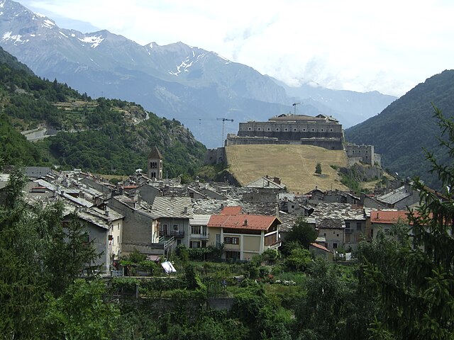

Эксиллес
- коммуна Италии
Hiking in Эксиллес
Exilles, located in the Susa Valley in the Piedmont region of Italy, is surrounded by the stunning landscapes of the Alps, making it an excellent destination for hiking enthusiasts. Here are some highlights and tips for hiking in and around Exilles:...
- Страна:
- Почтовый код: 10050
- Телефонный код: 0122
- Код автомобильного номера: TO
- Координаты: 45° 6' 0" N, 6° 56' 0" E
- GPS треки (wikiloc): [Ссылка]
- Высота над уровнем моря: 870 м m
- Площадь: 46.55 кв.км
- Население: 260
- Веб сайт: [Ссылка]
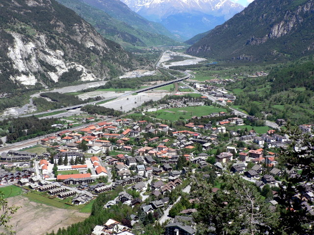

Улькс
- коммуна Италии
Hiking in Улькс
Oulx is a charming village located in the Susa Valley of the Italian Alps, and it’s a fantastic area for hiking enthusiasts. The region is known for its stunning mountain scenery, diverse trails, and opportunities for outdoor activities....
- Страна:
- Почтовый код: 10056
- Телефонный код: 0122
- Код автомобильного номера: TO
- Координаты: 45° 2' 0" N, 6° 50' 0" E
- GPS треки (wikiloc): [Ссылка]
- Высота над уровнем моря: 1100 м m
- Площадь: 99.79 кв.км
- Население: 3363
- Веб сайт: [Ссылка]