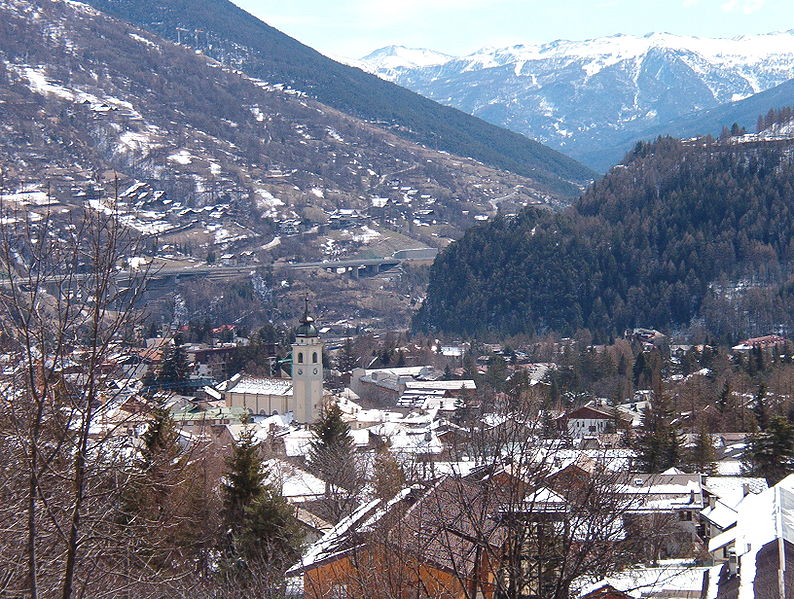
Модан (Modane, Modane)

- коммуна во Франции
 Hiking in Модан
Modane is a picturesque town located in the Savoie region of the French Alps, known for its stunning landscapes and proximity to various outdoor activities, including hiking. Here are some key points to consider if you're planning to hike in and around Modane:
Trails and Routes
-
L’Arc Valley: This area offers a range of trails with varying difficulty levels. You can find routes that lead to breathtaking views of the Arc River and surrounding peaks.
-
Fortifications Trail: Modane is home to several historical military fortifications. Hiking along these trails not only provides an excellent workout but also a chance to learn about the area's history.
-
Mont Cenis Pass: A bit further from Modane, this pass boasts scenic hiking paths that lead you through stunning mountain landscapes and beautiful lakes.
-
Vanoise National Park: Just a short distance from Modane, this national park features a multitude of trails. You can expect to encounter diverse wildlife, alpine meadows, and breathtaking vistas.
-
Valfréjus: Located close by, the Valfréjus area has marked hiking trails suitable for all levels, including gentle walks and more challenging hikes.
Best Time to Hike
- Summer (June to September): This is the best time for hiking in Modane, as the trails are usually clear of snow, and the weather is pleasant.
- Autumn (September to October): The fall brings stunning foliage and fewer crowds, making it a great time to hike, but be mindful of early snowfall.
Equipment and Preparation
- Footwear: Make sure to wear sturdy hiking boots that provide good ankle support.
- Clothing: Dress in layers; temperatures can vary greatly in the mountains.
- Water and Snacks: Bring sufficient water and snacks, especially for longer hikes.
- Navigation Tools: Maps, GPS devices, or hiking apps can help you stay on track.
Local Regulations and Safety
- Always check local guidelines regarding trail access and any seasonal restrictions.
- Make sure to inform someone about your hiking plans, especially if you're venturing alone.
- Be aware of wildlife and learn about the local flora and fauna.
Hiking Groups and Guides
If you're not familiar with the area or prefer guided experiences, consider joining a local hiking group or hiring a guide. There are numerous options in Modane that cater to various skill levels.
Hiking in Modane offers not just physical exercise but also the opportunity to immerse yourself in the stunning natural beauty and rich history of the French Alps. Enjoy your adventure!
- Страна:

- Почтовый код: 73500
- Координаты: 45° 12' 5" N, 6° 40' 24" E


- GPS треки (wikiloc): [Ссылка]
- Высота над уровнем моря: 1000 м m
- Площадь: 71.04 кв.км
- Население: 3180
- Веб сайт: http://www.modane-valfrejus.com
- Википедия русская: wiki(ru)
- Википедия английская: wiki(en)
- Википедия национальная: wiki(fr)
- Хранилище Wikidata: Wikidata: Q537113
- Катеория в википедии: [Ссылка]
- код Freebase: [/m/0gb34b]
- код GeoNames: Альт: [2993654]
- номер SIREN: [217301571]
- код BNF: [15274090d]
- код VIAF: Альт: [150235156]
- код LCNAF: Альт: [n91094911]
- место в MusicBrainz: [779beb43-7c46-4970-aa46-994875757e5c]
- код муниципалитета INSEE: 73157
- код US National Archives: 10037888
Граничит с регионами:

Saint-André
Hiking in Saint-André
Saint-André, located in the Savoie region of the French Alps, is an excellent destination for hiking enthusiasts. With its stunning alpine scenery, diverse trails, and rich natural biodiversity, the area offers various hiking opportunities suitable for all skill levels....
- Страна:
- Почтовый код: 73500
- Координаты: 45° 12' 4" N, 6° 37' 9" E
- GPS треки (wikiloc): [Ссылка]
- Площадь: 30.84 кв.км
- Население: 476


Freney
- коммуна во Франции
Hiking in Freney
Freney, often associated with the broader region of the French Alps, offers stunning scenery and a variety of hiking opportunities. The area is known for its striking mountain landscapes, glacial lakes, and picturesque valleys. Here are some key highlights and tips for hiking in and around Freney:...
- Страна:
- Почтовый код: 73500
- Координаты: 45° 11' 38" N, 6° 37' 37" E
- GPS треки (wikiloc): [Ссылка]
- Площадь: 11.13 кв.км
- Население: 105


Les Allues
- коммуна во Франции
Hiking in Les Allues
Les Allues is a charming village located in the French Alps, near the popular ski resort of Méribel in the Tarentaise Valley. While it is best known for its winter sports, Les Allues also offers beautiful hiking opportunities during the warmer months....
- Страна:
- Почтовый код: 73550
- Координаты: 45° 25' 51" N, 6° 33' 23" E
- GPS треки (wikiloc): [Ссылка]
- Площадь: 85.99 кв.км
- Население: 1848

Неваш
- коммуна во Франции
Hiking in Неваш
Névache, located in the Hautes-Alpes region of France, is a beautiful destination for hiking enthusiasts. Nestled in the Écrins National Park, Névache is known for its stunning landscapes, including alpine meadows, rugged mountains, and crystal-clear rivers. Here are some highlights and tips for hiking in the area:...
- Страна:
- Почтовый код: 05100
- Координаты: 45° 1' 7" N, 6° 36' 17" E
- GPS треки (wikiloc): [Ссылка]
- Площадь: 191.93 кв.км
- Население: 359
- Веб сайт: [Ссылка]


Pralognan-la-Vanoise
- коммуна во Франции
Hiking in Pralognan-la-Vanoise
Pralognan-la-Vanoise is a charming village located in the heart of the Vanoise National Park in the French Alps. It is an excellent destination for hiking enthusiasts, offering a diverse range of trails suitable for varying skill levels, as well as breathtaking scenery....
- Страна:
- Почтовый код: 73710
- Координаты: 45° 22' 53" N, 6° 43' 17" E
- GPS треки (wikiloc): [Ссылка]
- Площадь: 88.57 кв.км
- Население: 744
- Веб сайт: [Ссылка]


Аврие
- коммуна во Франции
Hiking in Аврие
Avrieux is a charming commune located in the Savoie department of the Auvergne-Rhône-Alpes region in southeastern France. Nestled in the French Alps, it offers beautiful landscapes and a variety of hiking opportunities....
- Страна:
- Почтовый код: 73500
- Координаты: 45° 12' 55" N, 6° 43' 15" E
- GPS треки (wikiloc): [Ссылка]
- Площадь: 37.85 кв.км
- Население: 397
- Веб сайт: [Ссылка]


Fourneaux
Hiking in Fourneaux
Fourneaux, located in the Savoie region of the French Alps, offers a variety of hiking opportunities for outdoor enthusiasts. The area is characterized by stunning alpine scenery, including mountains, valleys, and lush forests. Here are some key points to consider if you're planning a hiking trip in Fourneaux:...
- Страна:
- Почтовый код: 73500
- Координаты: 45° 11' 29" N, 6° 39' 6" E
- GPS треки (wikiloc): [Ссылка]
- Площадь: 5.04 кв.км
- Население: 666

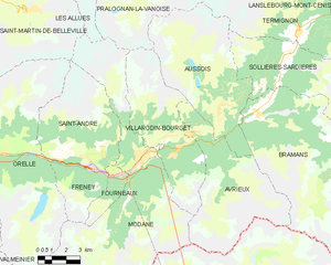
Villarodin-Bourget
- коммуна во Франции
Hiking in Villarodin-Bourget
Villarodin-Bourget is a charming village located in the French Alps, near the Italian border, and forms part of the Maurienne valley. It offers a variety of hiking opportunities for both beginners and experienced hikers, with stunning landscapes and diverse trails....
- Страна:
- Почтовый код: 73500
- Координаты: 45° 12' 50" N, 6° 41' 48" E
- GPS треки (wikiloc): [Ссылка]
- Площадь: 33.08 кв.км
- Население: 521
- Веб сайт: [Ссылка]


Orelle
- коммуна во Франции
Hiking in Orelle
Orelle, a picturesque village located in the French Alps, is an excellent destination for hiking enthusiasts. It is situated near the Maurienne Valley and provides access to a variety of trails that cater to all skill levels, from beginners to advanced hikers....
- Страна:
- Почтовый код: 73140
- Координаты: 45° 12' 33" N, 6° 32' 13" E
- GPS треки (wikiloc): [Ссылка]
- Площадь: 69.25 кв.км
- Население: 352

Бардонеккия
- коммуна Италии
Hiking in Бардонеккия
Bardonecchia, located in the Susa Valley of the Piedmont region of Italy, is a popular destination for hiking enthusiasts, offering a range of trails that cater to different skill levels and preferences. The area is known for its stunning alpine scenery, diverse ecosystems, and rich cultural heritage....
- Страна:

- Почтовый код: 10052
- Телефонный код: 0122
- Код автомобильного номера: TO
- Координаты: 45° 4' 42" N, 6° 42' 14" E
- GPS треки (wikiloc): [Ссылка]
- Высота над уровнем моря: 1312 м m
- Площадь: 132.2 кв.км
- Население: 3155
- Веб сайт: [Ссылка]