Battenans-les-Mines (Battenans-les-Mines)

- коммуна во Франции
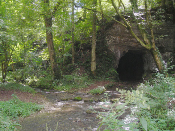
 Hiking in Battenans-les-Mines
Battenans-les-Mines is a small commune in the Doubs department in the Bourgogne-Franche-Comté region of eastern France. While it may not be as well-known as some larger hiking destinations, its natural surroundings offer some opportunities for hiking enthusiasts.
Hiking in and around Battenans-les-Mines:
-
Scenic Trails: The area around Battenans-les-Mines is characterized by beautiful landscapes, including forests and rolling hills. You can find various trails that wind through these scenic areas, allowing hikers to enjoy the natural beauty of the region.
-
Local Wildlife: As you hike, you may encounter diverse flora and fauna. The forests and fields are home to a variety of wildlife, making the area a pleasant experience for nature lovers and bird watchers.
-
Proximity to Larger Hiking Areas: Battenans-les-Mines is located near larger towns and natural reserves, such as the Doubs Valley and the Jura Mountains, which offer extensive hiking trails and more challenging terrain for those seeking a more adventurous experience.
-
Historical Sites: The region is dotted with historical sites and charming villages, making it possible to incorporate cultural exploration into your hikes.
-
Trail Recommendations: Since specific trails may vary, it’s advisable to check local maps or visit the tourist information center in nearby larger towns to get updated information on marked trails and their difficulty levels.
Tips for Hiking in Battenans-les-Mines:
-
Check Weather Conditions: Always check the weather before heading out, as conditions can change rapidly in the region.
-
Preparation: Wear appropriate hiking gear, including sturdy footwear, and carry enough water and snacks.
-
Local Resources: Consider reaching out to local hiking clubs or tourism offices for guided hikes or to obtain detailed maps of the area.
-
Leave No Trace: Follow the principles of Leave No Trace to protect the natural environment during your hiking adventures.
Overall, while Battenans-les-Mines may not be a major hiking destination, it offers a charming escape for those looking to enjoy nature and the tranquility of the French countryside.
- Страна:

- Почтовый код: 25640
- Координаты: 47° 24' 35" N, 6° 16' 7" E


- GPS треки (wikiloc): [Ссылка]
- Площадь: 2.78 кв.км
- Население: 61
- Википедия английская: wiki(en)
- Википедия национальная: wiki(fr)
- Хранилище Wikidata: Wikidata: Q810925
- Катеория в википедии: [Ссылка]
- код Freebase: [/m/03mgc42]
- код Freebase: [/m/03mgc42]
- код GeoNames: Альт: [6447831]
- код GeoNames: Альт: [6447831]
- номер SIREN: [212500458]
- номер SIREN: [212500458]
- код BNF: [15252271s]
- код BNF: [15252271s]
- код муниципалитета INSEE: 25045
- код муниципалитета INSEE: 25045
Граничит с регионами:


Avilley
- коммуна во Франции
Hiking in Avilley
Avilley is a charming commune located in the Haute-Saône department in the Bourgogne-Franche-Comté region of eastern France. While it may not be as widely recognized as some other hiking destinations, it offers beautiful natural landscapes and opportunities for outdoor enthusiasts....
- Страна:
- Почтовый код: 25680
- Координаты: 47° 25' 33" N, 6° 16' 3" E
- GPS треки (wikiloc): [Ссылка]
- Площадь: 5.62 кв.км
- Население: 170

Rougemontot
- коммуна во Франции
Hiking in Rougemontot
Rougemontot is a picturesque destination located in the region of the Jura Mountains in France, known for its stunning natural scenery and outdoor activities, including hiking. Here are some things to consider if you're planning to hike in Rougemontot:...
- Страна:
- Почтовый код: 25640
- Координаты: 47° 23' 51" N, 6° 15' 46" E
- GPS треки (wikiloc): [Ссылка]
- Площадь: 4.25 кв.км
- Население: 93


Tournans
- коммуна во Франции
Hiking in Tournans
Tournans is a beautiful area that offers a variety of hiking opportunities, showcasing its natural beauty and diverse landscapes. The region typically features scenic trails that can accommodate different skill levels, from beginner-friendly paths to more challenging routes for seasoned hikers....
- Страна:
- Почтовый код: 25680
- Координаты: 47° 24' 49" N, 6° 19' 39" E
- GPS треки (wikiloc): [Ссылка]
- Площадь: 9.14 кв.км
- Население: 132


Tallans
Hiking in Tallans
It seems you might be referring to a specific area or region, but I'm not familiar with "Tallans" as a recognized hiking destination. It's possible it could be a local name or a smaller area not widely known....
- Страна:
- Почтовый код: 25680
- Координаты: 47° 25' 13" N, 6° 17' 17" E
- GPS треки (wikiloc): [Ссылка]
- Площадь: 4.05 кв.км
- Население: 52