Tournans (Tournans)

- коммуна во Франции
 Hiking in Tournans
Tournans is a beautiful area that offers a variety of hiking opportunities, showcasing its natural beauty and diverse landscapes. The region typically features scenic trails that can accommodate different skill levels, from beginner-friendly paths to more challenging routes for seasoned hikers.
When hiking in Tournans, here are a few tips to keep in mind:
-
Trail Selection: Research and choose a trail that matches your fitness level and hiking experience. Local hiking maps or apps can help you identify routes and their difficulties.
-
Preparation: Carry adequate supplies such as water, snacks, a first-aid kit, a map, and a compass. Make sure to wear appropriate footwear for the terrain.
-
Weather Conditions: Always check the weather forecast before setting out, and be prepared for sudden changes in weather, which can be common in outdoor areas.
-
Respect Nature: Stay on marked trails to protect the environment, and ensure to practice Leave No Trace principles by packing out what you pack in.
-
Local Wildlife: Be aware of the wildlife in the area, and know how to safely encounter animals, as well as how to manage any potential risks.
-
Group Hiking: If you're going with a group, establish a pace that works for everyone and designate a meeting spot in case anyone gets separated.
-
Navigation: Familiarize yourself with the trail and have a backup navigation method, such as a physical map or GPS device.
-
Emergency Preparedness: Let someone know your hiking plans and estimated return time, and consider carrying a whistle or a personal locator beacon in case of emergencies.
Exploring Tournans through hiking can be a rewarding experience. Be sure to take time to appreciate the views and the natural surroundings! If you have more specific questions about trails or requirements in Tournans, feel free to ask.
- Страна:

- Почтовый код: 25680
- Координаты: 47° 24' 49" N, 6° 19' 39" E


- GPS треки (wikiloc): [Ссылка]
- Площадь: 9.14 кв.км
- Население: 132
- Википедия английская: wiki(en)
- Википедия национальная: wiki(fr)
- Хранилище Wikidata: Wikidata: Q906173
- Катеория в википедии: [Ссылка]
- код Freebase: [/m/03mhdjc]
- код GeoNames: Альт: [6430015]
- номер SIREN: [212505671]
- код BNF: [15252793g]
- код тезауруса PACTOLS: [pcrt1bktmkxnQT]
- код муниципалитета INSEE: 25567
Граничит с регионами:

Huanne-Montmartin
- коммуна во Франции
Hiking in Huanne-Montmartin
Huanne-Montmartin is a picturesque commune located in the Vosges department of northeastern France, known for its scenic landscapes and outdoor activities, including hiking. The region offers a mix of lush forests, rolling hills, and vibrant flora and fauna, making it an attractive destination for both casual walkers and trekking enthusiasts....
- Страна:
- Почтовый код: 25680
- Координаты: 47° 25' 52" N, 6° 20' 40" E
- GPS треки (wikiloc): [Ссылка]
- Площадь: 3.43 кв.км
- Население: 83


Battenans-les-Mines
- коммуна во Франции
Hiking in Battenans-les-Mines
Battenans-les-Mines is a small commune in the Doubs department in the Bourgogne-Franche-Comté region of eastern France. While it may not be as well-known as some larger hiking destinations, its natural surroundings offer some opportunities for hiking enthusiasts....
- Страна:
- Почтовый код: 25640
- Координаты: 47° 24' 35" N, 6° 16' 7" E
- GPS треки (wikiloc): [Ссылка]
- Площадь: 2.78 кв.км
- Население: 61

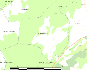
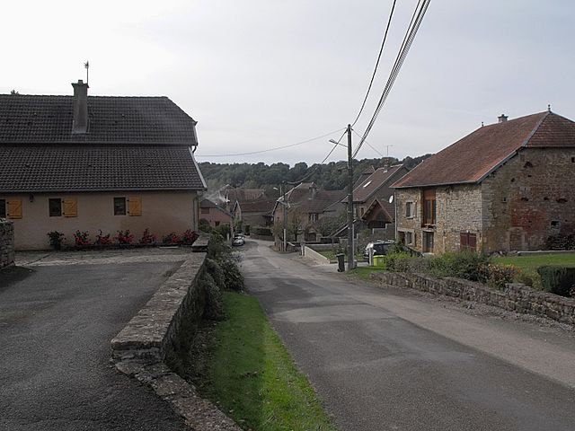
Fontenotte
- коммуна во Франции
Hiking in Fontenotte
Hiking in Fontenotte, a picturesque area often associated with its natural beauty, can offer a delightful experience for outdoor enthusiasts. While specific trail details may vary, here are some general aspects you can expect:...
- Страна:
- Почтовый код: 25110
- Координаты: 47° 22' 35" N, 6° 19' 21" E
- GPS треки (wikiloc): [Ссылка]
- Площадь: 5.65 кв.км
- Население: 59


La Bretenière
- коммуна во Франции
Hiking in La Bretenière
La Bretenière, located in the Doubs department of France, offers a picturesque setting for hiking enthusiasts. The area is characterized by its beautiful natural landscapes, including rolling hills, lush forests, and meandering rivers, making it a great spot for both casual walkers and more experienced hikers....
- Страна:
- Почтовый код: 25640
- Координаты: 47° 22' 52" N, 6° 16' 28" E
- GPS треки (wikiloc): [Ссылка]
- Площадь: 4.16 кв.км
- Население: 70


Rognon
- коммуна во Франции
Hiking in Rognon
Rognon, located in the Doubs department of France, is a lesser-known gem for hiking enthusiasts. The region is characterized by its stunning natural landscapes, including rolling hills, dense forests, and rocky outcrops. Here are some key points to consider when hiking in Rognon:...
- Страна:
- Почтовый код: 25680
- Координаты: 47° 25' 29" N, 6° 18' 43" E
- GPS треки (wikiloc): [Ссылка]
- Площадь: 4.09 кв.км
- Население: 50


Verne
- коммуна во Франции
Hiking in Verne
Verne, located in the Doubs department of the Bourgogne-Franche-Comté region in eastern France, offers a variety of hiking opportunities for outdoor enthusiasts. The area is characterized by its beautiful natural landscapes, with rolling hills, lush forests, and picturesque valleys....
- Страна:
- Почтовый код: 25110
- Координаты: 47° 23' 53" N, 6° 21' 14" E
- GPS треки (wikiloc): [Ссылка]
- Площадь: 7.82 кв.км
- Население: 130
- Веб сайт: [Ссылка]

Trouvans
- коммуна во Франции
Hiking in Trouvans
Trouvans, located in the beautiful French region of Bourgogne-Franche-Comté, offers a quaint and picturesque setting for hiking enthusiasts. While not as widely known as some other hiking destinations in France, it boasts scenic trails that are ideal for both beginners and more experienced hikers....
- Страна:
- Почтовый код: 25680
- Координаты: 47° 25' 24" N, 6° 20' 54" E
- GPS треки (wikiloc): [Ссылка]
- Площадь: 2.69 кв.км
- Население: 103


Tallans
Hiking in Tallans
It seems you might be referring to a specific area or region, but I'm not familiar with "Tallans" as a recognized hiking destination. It's possible it could be a local name or a smaller area not widely known....
- Страна:
- Почтовый код: 25680
- Координаты: 47° 25' 13" N, 6° 17' 17" E
- GPS треки (wikiloc): [Ссылка]
- Площадь: 4.05 кв.км
- Население: 52