Бомот-Обертан (Beaumotte-Aubertans, Beaumotte-Aubertans)

- коммуна во Франции
 Hiking in Бомот-Обертан
Beaumotte-Aubertans is a picturesque commune located in the Bourgogne-Franche-Comté region of France. While not as famous as some larger hiking destinations, the area offers a great opportunity for outdoor enthusiasts to explore beautiful landscapes, including rolling hills, forests, and charming rural scenery.
Hiking Opportunities
-
Trails: The trails in and around Beaumotte-Aubertans often range from easy walks suitable for families to more challenging hikes for experienced trekkers. Many routes allow hikers to enjoy the natural beauty of the area, including views of the surrounding countryside.
-
Nature: The region is rich in biodiversity, and hikers may encounter a variety of flora and fauna. Birdwatching can also be rewarding, especially in quieter areas away from urban settings.
-
Scenic Spots: Look for local viewpoints that offer panoramic views of the landscape. These spots are often perfect for a quick rest or a picnic.
-
Cultural Heritage: Explore the local heritage and small villages during your hike. Many paths may lead to historical sites or charming farms, giving hikers a glimpse into the traditional rural life of the region.
Preparation and Tips
-
Maps and Guides: It's a good idea to have a local hiking map or guide, as well as a GPS device or app, to help navigate the trails.
-
Weather: Check the weather forecast before heading out, as conditions can change rapidly. Dress in layers and be prepared for both sun and rain.
-
Supplies: Bring plenty of water, snacks, and a first-aid kit, especially if you plan to hike for several hours.
-
Respect Nature: Follow local guidelines to preserve the landscape. Stick to marked trails, pack out what you pack in, and minimize your impact on the environment.
-
Local Regulations: Familiarize yourself with any local regulations regarding hiking, as some areas may have restrictions or require permits.
Hiking in Beaumotte-Aubertans can offer a peaceful and scenic escape into nature, perfect for those looking to enjoy a less touristy destination in France.
- Страна:

- Почтовый код: 70190
- Координаты: 47° 25' 12" N, 6° 10' 45" E


- GPS треки (wikiloc): [Ссылка]
- Высота над уровнем моря: 270 м m
- Площадь: 13.57 кв.км
- Население: 431
- Википедия русская: wiki(ru)
- Википедия английская: wiki(en)
- Википедия национальная: wiki(fr)
- Хранилище Wikidata: Wikidata: Q767889
- Катеория в википедии: [Ссылка]
- код Freebase: [/m/03nt1lt]
- код GeoNames: Альт: [6617467]
- номер SIREN: [217000595]
- код BNF: [15272453t]
- код муниципалитета INSEE: 70059
Граничит с регионами:


Сенан
- коммуна во Франции, департамент Верхняя Сона
- Страна:
- Почтовый код: 70230
- Координаты: 47° 25' 53" N, 6° 11' 46" E
- GPS треки (wikiloc): [Ссылка]
- Площадь: 5.02 кв.км
- Население: 123


Ванделан
- коммуна во Франции
Hiking in Ванделан
It seems there might be a small misunderstanding, as "Vandelans" doesn’t appear to refer to a well-known hiking destination or location that I am aware of as of my last knowledge update in October 2023. However, if you meant a different location or if "Vandelans" is a local term or a lesser-known area, I’d be happy to provide general hiking information or tips, or discuss hikes in popular areas....
- Страна:
- Почтовый код: 70190
- Координаты: 47° 23' 41" N, 6° 9' 53" E
- GPS треки (wikiloc): [Ссылка]
- Площадь: 3.08 кв.км
- Население: 118


Виллер-Патер
- коммуна во Франции
- Страна:
- Почтовый код: 70190
- Координаты: 47° 28' 1" N, 6° 9' 43" E
- GPS треки (wikiloc): [Ссылка]
- Площадь: 4.67 кв.км
- Население: 49

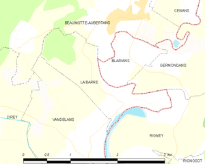
Ла-Бар
- коммуна во Франции, департамент Верхняя Сона
Hiking in Ла-Бар
La Barre, located in the Haute-Saône department in the Bourgogne-Franche-Comté region of eastern France, offers a variety of hiking opportunities that showcase the region's beautiful landscapes, rolling hills, and rich biodiversity. Here are some key points to consider for hiking in La Barre and the surrounding areas:...
- Страна:
- Почтовый код: 70190
- Координаты: 47° 24' 17" N, 6° 10' 47" E
- GPS треки (wikiloc): [Ссылка]
- Высота над уровнем моря: 210 м m
- Площадь: 1.93 кв.км
- Население: 103

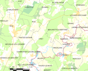
Сире
- коммуна во Франции
Hiking in Сире
Cirey is a small commune located in the Haute-Marne department in northeastern France. While it may not be as widely recognized as larger hiking destinations, it offers beautiful landscapes and opportunities for outdoor activities, especially for those who enjoy peaceful rural settings....
- Страна:
- Почтовый код: 70190
- Координаты: 47° 23' 47" N, 6° 7' 57" E
- GPS треки (wikiloc): [Ссылка]
- Площадь: 13.09 кв.км
- Население: 358
- Веб сайт: [Ссылка]


Germondans
- коммуна во Франции
Hiking in Germondans
Germondans, a picturesque area located in the Franche-Comté region of eastern France, is known for its stunning natural landscapes and rich history. Hiking in this region can offer a range of experiences from gentle walks to more challenging treks. Here are some highlights and tips for hiking in Germondans:...
- Страна:
- Почтовый код: 25640
- Координаты: 47° 24' 33" N, 6° 11' 27" E
- GPS треки (wikiloc): [Ссылка]
- Площадь: 3.52 кв.км
- Население: 60


Blarians
- коммуна во Франции
Hiking in Blarians
It looks like there might be a small typo or misunderstanding regarding "Blarians." If you meant "Blarney" or another well-known hiking destination, let me know, and I can provide you with specific information about that area....
- Страна:
- Почтовый код: 25640
- Координаты: 47° 24' 42" N, 6° 10' 47" E
- GPS треки (wikiloc): [Ссылка]
- Площадь: 0.89 кв.км
- Население: 60

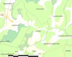
Рюан
- коммуна во Франции
- Страна:
- Почтовый код: 70190
- Координаты: 47° 27' 33" N, 6° 8' 10" E
- GPS треки (wikiloc): [Ссылка]
- Площадь: 4.95 кв.км
- Население: 160


Лулан-Вершан
- коммуна во Франции
- Страна:
- Почтовый код: 70230
- Координаты: 47° 26' 48" N, 6° 12' 22" E
- GPS треки (wikiloc): [Ссылка]
- Высота над уровнем моря: 254 м m
- Площадь: 8.16 кв.км
- Население: 460
- Веб сайт: [Ссылка]