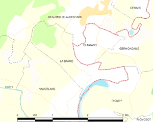
Germondans (Germondans)

- коммуна во Франции
 Hiking in Germondans
Germondans, a picturesque area located in the Franche-Comté region of eastern France, is known for its stunning natural landscapes and rich history. Hiking in this region can offer a range of experiences from gentle walks to more challenging treks. Here are some highlights and tips for hiking in Germondans:
Scenic Trails
- Local Trails: The area offers a variety of marked trails that showcase the beautiful countryside, rolling hills, and forests. Many trails are well-maintained and suitable for various skill levels.
- Viewpoints: There are several elevated points along the trails where hikers can enjoy panoramic views of the Jura mountains and surrounding valleys.
Flora and Fauna
- The diverse ecosystems in Germondans provide habitats for a wide array of plant and animal species. Bring binoculars for birdwatching, and keep an eye out for deer and other wildlife along the trails.
Historical Sites
- As you hike, you may encounter historical relics, such as old stone walls, farms, and remnants of ancient settlements, offering a glimpse into the region’s past.
Preparing for Your Hike
- Weather Considerations: The weather can change rapidly in mountainous areas, so it’s essential to check forecasts before you set out. Dress in layers and be prepared for rain.
- Hydration and Snacks: Carry enough water and nutritious snacks for the journey, especially if you're planning a long hike.
- Trail Maps: Always have a trail map or a GPS device. Some areas may not have cell service, and it's easy to stray off designated paths.
Safety Tips
- Inform someone about your hiking plans and expected return time.
- Always stick to marked trails, as wandering off can lead to getting lost or damaging the environment.
Best Times to Hike
- The best seasons for hiking in Germondans are late spring to early autumn when the weather is generally mild and flora is vibrant.
Local Amenities
- Depending on the specific area within Germondans, you may find small villages with cafes, restaurants, and accommodation options where you can rest and refuel after a long day of hiking.
Remember to leave no trace, respect wildlife, and enjoy the stunning beauty that Germondans has to offer. Happy hiking!
- Страна:

- Почтовый код: 25640
- Координаты: 47° 24' 33" N, 6° 11' 27" E


- GPS треки (wikiloc): [Ссылка]
- Площадь: 3.52 кв.км
- Население: 60
- Википедия английская: wiki(en)
- Википедия национальная: wiki(fr)
- Хранилище Wikidata: Wikidata: Q836623
- Катеория в википедии: [Ссылка]
- код Freebase: [/m/03mh8nw]
- код Freebase: [/m/03mh8nw]
- код GeoNames: Альт: [6612389]
- код GeoNames: Альт: [6612389]
- номер SIREN: [212502694]
- номер SIREN: [212502694]
- код BNF: [15252495b]
- код BNF: [15252495b]
- код муниципалитета INSEE: 25269
- код муниципалитета INSEE: 25269
Граничит с регионами:


Rigney
- коммуна во Франции
Hiking in Rigney
It seems that there isn't a well-known hiking area specifically named "Rigney." However, if you're referring to a specific location related to hiking, please clarify, and I would be glad to provide information!...
- Страна:
- Почтовый код: 25640
- Координаты: 47° 23' 17" N, 6° 10' 33" E
- GPS треки (wikiloc): [Ссылка]
- Площадь: 9.58 кв.км
- Население: 406
- Веб сайт: [Ссылка]


Сенан
- коммуна во Франции, департамент Верхняя Сона
- Страна:
- Почтовый код: 70230
- Координаты: 47° 25' 53" N, 6° 11' 46" E
- GPS треки (wikiloc): [Ссылка]
- Площадь: 5.02 кв.км
- Население: 123


Бомот-Обертан
- коммуна во Франции
Hiking in Бомот-Обертан
Beaumotte-Aubertans is a picturesque commune located in the Bourgogne-Franche-Comté region of France. While not as famous as some larger hiking destinations, the area offers a great opportunity for outdoor enthusiasts to explore beautiful landscapes, including rolling hills, forests, and charming rural scenery....
- Страна:
- Почтовый код: 70190
- Координаты: 47° 25' 12" N, 6° 10' 45" E
- GPS треки (wikiloc): [Ссылка]
- Высота над уровнем моря: 270 м m
- Площадь: 13.57 кв.км
- Население: 431

Ла-Бар
- коммуна во Франции, департамент Верхняя Сона
Hiking in Ла-Бар
La Barre, located in the Haute-Saône department in the Bourgogne-Franche-Comté region of eastern France, offers a variety of hiking opportunities that showcase the region's beautiful landscapes, rolling hills, and rich biodiversity. Here are some key points to consider for hiking in La Barre and the surrounding areas:...
- Страна:
- Почтовый код: 70190
- Координаты: 47° 24' 17" N, 6° 10' 47" E
- GPS треки (wikiloc): [Ссылка]
- Высота над уровнем моря: 210 м m
- Площадь: 1.93 кв.км
- Население: 103


La Tour-de-Sçay
- коммуна во Франции
Hiking in La Tour-de-Sçay
La Tour-de-Sçay, located in the beautiful region of Haute-Savoie in France, offers a variety of hiking opportunities that showcase the stunning landscapes of the French Alps. Here are some key points to consider for hiking in this region:...
- Страна:
- Почтовый код: 25640
- Координаты: 47° 23' 12" N, 6° 13' 34" E
- GPS треки (wikiloc): [Ссылка]
- Площадь: 8.82 кв.км
- Население: 287


Лулан-Вершан
- коммуна во Франции
- Страна:
- Почтовый код: 70230
- Координаты: 47° 26' 48" N, 6° 12' 22" E
- GPS треки (wikiloc): [Ссылка]
- Высота над уровнем моря: 254 м m
- Площадь: 8.16 кв.км
- Население: 460
- Веб сайт: [Ссылка]