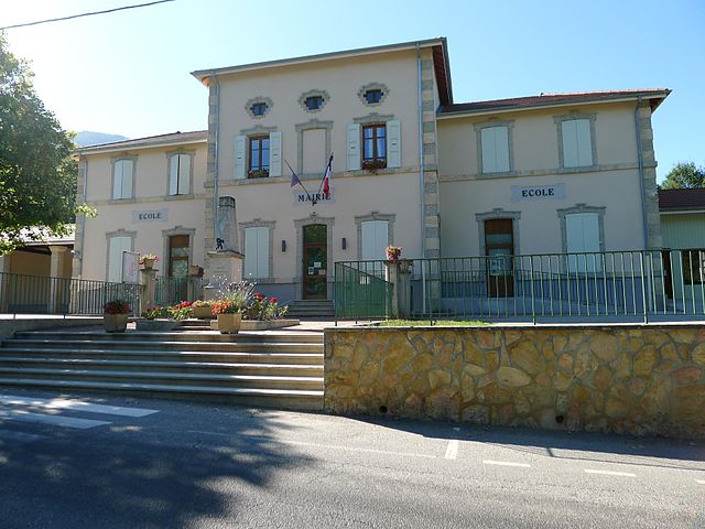
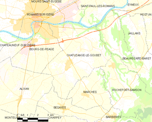
Beauregard-Baret (Beauregard-Baret)

- коммуна во Франции
 Hiking in Beauregard-Baret
Beauregard-Baret is a picturesque region located in the Drôme department of southeastern France. Known for its beautiful landscapes, it's a fantastic destination for hiking enthusiasts of all levels.
Hiking Trails
-
Overview: The area features a range of trails, from easy walks suitable for families to more challenging hikes for experienced trekkers. Many trails offer stunning views of the surrounding mountains and valleys.
-
Key Trails:
- Trail of the Gorges de la Partie: This trail offers a scenic route through impressive gorges and is well-marked.
- Les Crêtes de la Sure: A more challenging hike that rewards you with breathtaking panoramic views of the Vercors and the Diois mountains.
- Les Sentiers du Patrimoine: These trails take you through historic and cultural sites in the region, giving a taste of the local heritage.
Best Time to Hike
- Spring (April to June): Best time for wildflowers and mild temperatures.
- Fall (September to October): Enjoy the autumn colors, with comfortable hiking conditions.
- Summer: Can be hot, so early morning or late afternoon hikes are preferable.
What to Bring
- Hiking Boots: Proper footwear is essential for uneven terrain.
- Water: Stay hydrated, especially during warmer months.
- Snacks: Energy bars or fruit for a quick refuel.
- Map/GPS: While trails are marked, a map or GPS device can help with navigation.
- Weather Gear: Depending on the season, be prepared for sudden changes in weather.
Local Tips
- Stay on Marked Trails: To preserve the environment and ensure safety.
- Respect Wildlife: Observe animals from a distance and do not disturb them.
- Check Local Regulations: Some areas may have specific rules regarding fire, camping, and trail access.
Accommodations
There are various options for staying in or near Beauregard-Baret, from cozy gîtes to camping sites, catering to different budgets and preferences.
Overall, hiking in Beauregard-Baret is a rewarding experience that combines natural beauty, cultural history, and outdoor adventure. Whether you're seeking solitude or the challenge of the trails, this region has much to offer.
- Страна:

- Почтовый код: 26300
- Координаты: 45° 0' 57" N, 5° 9' 5" E


- GPS треки (wikiloc): [Ссылка]
- Площадь: 23.44 кв.км
- Население: 808
- Веб сайт: http://www.mairie-beauregardbaret.fr
- Википедия английская: wiki(en)
- Википедия национальная: wiki(fr)
- Хранилище Wikidata: Wikidata: Q383679
- Катеория в википедии: [Ссылка]
- код Freebase: [/m/03mgl8w]
- код GeoNames: Альт: [6447883]
- номер SIREN: [212600399]
- код BNF: [152529006]
- код тезауруса PACTOLS: [pcrtU3nIM5keEY]
- код муниципалитета INSEE: 26039
Граничит с регионами:
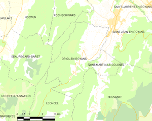
Oriol-en-Royans
- коммуна во Франции
Hiking in Oriol-en-Royans
Oriol-en-Royans is a charming village located in the Auvergne-Rhône-Alpes region of southeastern France, nestled in the stunning Vercors Massif. This area offers a wide array of hiking opportunities, ranging from easy scenic strolls to more challenging ascents. Here are some highlights for hiking in the region:...
- Страна:
- Почтовый код: 26190
- Координаты: 44° 59' 54" N, 5° 16' 27" E
- GPS треки (wikiloc): [Ссылка]
- Площадь: 16.01 кв.км
- Население: 538
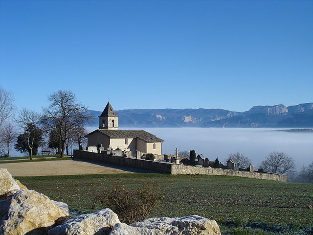

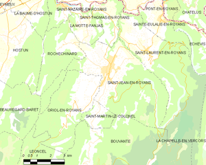
Rochechinard
- коммуна во Франции
Hiking in Rochechinard
Rochechinard is a beautiful area located in the French Alps, known for its stunning landscapes, diverse flora and fauna, and a variety of hiking routes that cater to different skill levels. Here are some key points to consider if you’re planning a hiking trip in Rochechinard:...
- Страна:
- Почтовый код: 26190
- Координаты: 45° 2' 3" N, 5° 15' 12" E
- GPS треки (wikiloc): [Ссылка]
- Площадь: 9.78 кв.км
- Население: 110


Saint-Paul-lès-Romans
- коммуна во Франции
Hiking in Saint-Paul-lès-Romans
Saint-Paul-lès-Romans is a charming commune in the Drôme department of southeastern France, located near the picturesque Rhône-Alpes region. The area offers a variety of hiking opportunities, characterized by its beautiful landscapes, historical sites, and natural features....
- Страна:
- Почтовый код: 26750
- Координаты: 45° 4' 3" N, 5° 7' 58" E
- GPS треки (wikiloc): [Ссылка]
- Площадь: 15.77 кв.км
- Население: 1814
Chatuzange-le-Goubet
- коммуна во Франции
Hiking in Chatuzange-le-Goubet
Chatuzange-le-Goubet is a charming commune located in the Drôme department of southeastern France, nestled near the picturesque foothills of the Alps. While the area is not as widely recognized for hiking as some of its neighboring regions, it still offers beautiful landscapes and serene trails that can appeal to outdoor enthusiasts....
- Страна:
- Почтовый код: 26300
- Координаты: 45° 0' 24" N, 5° 5' 27" E
- GPS треки (wikiloc): [Ссылка]
- Высота над уровнем моря: 238 м m
- Площадь: 28.24 кв.км
- Население: 5311
- Веб сайт: [Ссылка]


Eymeux
- коммуна во Франции
Hiking in Eymeux
Eymeux is a charming village located in the Auvergne-Rhône-Alpes region of France, known for its picturesque landscapes and natural beauty. Hiking in and around Eymeux offers a variety of trails that cater to different skill levels, making it a fantastic destination for outdoor enthusiasts....
- Страна:
- Почтовый код: 26730
- Координаты: 45° 4' 41" N, 5° 10' 42" E
- GPS треки (wikiloc): [Ссылка]
- Площадь: 9.88 кв.км
- Население: 1046


Hostun
Hiking in Hostun
Hostun, located in the Drôme department of southeastern France, offers beautiful landscapes and a variety of hiking opportunities. This area is characterized by its rolling hills, picturesque villages, and access to the natural beauty of the Vercors Regional Natural Park nearby. Here are some highlights regarding hiking in Hostun and its surroundings:...
- Страна:
- Почтовый код: 26730
- Координаты: 45° 2' 22" N, 5° 11' 53" E
- GPS треки (wikiloc): [Ссылка]
- Площадь: 18.24 кв.км
- Население: 963

Saint-Jean-en-Royans
- коммуна во Франции
Hiking in Saint-Jean-en-Royans
Saint-Jean-en-Royans is a picturesque village located in the Drôme department in the Auvergne-Rhône-Alpes region of southeastern France. Nestled at the foothills of the Vercors Massif, it offers a variety of hiking opportunities that cater to different skill levels and interests....
- Страна:
- Почтовый код: 26190
- Координаты: 45° 1' 7" N, 5° 17' 32" E
- GPS треки (wikiloc): [Ссылка]
- Площадь: 27.86 кв.км
- Население: 2967


Rochefort-Samson
- коммуна во Франции
Hiking in Rochefort-Samson
Rochefort-Samson, located in the Drôme department of the Auvergne-Rhône-Alpes region in southeastern France, is known for its beautiful landscapes, diverse flora and fauna, and welcoming hiking trails. Here are some key highlights for hiking in this area:...
- Страна:
- Почтовый код: 26300
- Координаты: 44° 58' 23" N, 5° 9' 6" E
- GPS треки (wikiloc): [Ссылка]
- Площадь: 24.59 кв.км
- Население: 994

Jaillans
- коммуна во Франции
Hiking in Jaillans
Jaillans is a small commune in the Drôme department of the Auvergne-Rhône-Alpes region in southeastern France. While it may not be as well-known as some larger hiking destinations, it offers picturesque landscapes and a tranquil environment, making it a great spot for hiking enthusiasts who prefer less crowded paths....
- Страна:
- Почтовый код: 26300
- Координаты: 45° 1' 41" N, 5° 10' 28" E
- GPS треки (wikiloc): [Ссылка]
- Площадь: 9.04 кв.км
- Население: 896

Léoncel
- коммуна во Франции
Hiking in Léoncel
Léoncel is a beautiful village located in the Drôme department of the Auvergne-Rhône-Alpes region in southeastern France. It is situated in the Vercors Massif, which offers diverse landscapes and rich natural beauty, making it an excellent destination for hiking enthusiasts....
- Страна:
- Почтовый код: 26190
- Координаты: 44° 54' 39" N, 5° 11' 34" E
- GPS треки (wikiloc): [Ссылка]
- Площадь: 43.01 кв.км
- Население: 58