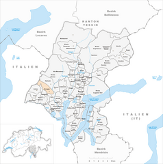
Bedigliora (Bedigliora)

 Hiking in Bedigliora
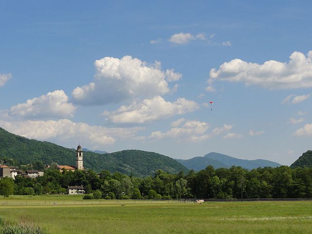
Bedigliora is a charming village located in the canton of Ticino in Switzerland. It offers beautiful landscapes, serene environments, and a variety of hiking opportunities. Here are some highlights about hiking in and around Bedigliora:
Trails and Scenery:
-
Diverse Terrain: The hiking trails around Bedigliora feature varying terrains, from gentle hills to more challenging rocky paths. You can enjoy views of Lake Lugano, lush forests, and charming Swiss architecture.
-
Flora and Fauna: The area is rich in biodiversity, with opportunities to see a variety of plant and animal species, especially during the spring and summer months.
-
Network of Trails: Numerous marked trails connect Bedigliora with nearby towns and villages, such as Lugano and Ponte Tresa. You can choose between easy walks for families and more strenuous hikes for experienced trekkers.
Popular Hiking Routes:
-
Monte Brè: A popular mountain for hikers offering stunning panoramic views of the surrounding areas. The trail can be accessed via Bedigliora and offers various routes depending on your desired difficulty level.
-
Sentiero Novaggio: This scenic path leads through picturesque scenery and provides a fantastic hiking experience for all skill levels.
Practical Information:
-
Maps and Signage: It’s advisable to pick up local hiking maps, available at tourist information centers. The trails are generally well-marked, but it's always good to have a map for reference.
-
Weather Considerations: The weather in this region can change quickly, so it's essential to check the forecast and dress in layers. Always carry enough water and snacks.
-
Safety Precautions: As with any hiking adventure, ensure you have proper footwear and gear. If you plan to hike in the mountains, let someone know your plans and estimated return time.
Local Amenities:
Bedigliora itself has quaint shops and restaurants where you can stop for refreshments or a meal after your hike. Be sure to sample some local Ticinese cuisine!
Conclusion:
Hiking in Bedigliora can be a delightful experience, offering nature lovers a chance to connect with the stunning Swiss landscape. Whether you're seeking a peaceful walk or an adventurous trek, the area has something to offer for every hiker. Always remember to respect the environment and adhere to local guidelines while enjoying your hike!
- Страна:

- Почтовый код: 6981
- Телефонный код: 091
- Код автомобильного номера: TI
- Координаты: 46° 0' 0" N, 8° 51' 0" E


- GPS треки (wikiloc): [Ссылка]
- Высота над уровнем моря: 617 м m
- Площадь: 2.5 кв.км
- Население: 634
- Веб сайт: http://www.ti.ch/can/comuni/pagine/presentazione.asp?ID_comune=509&Comune=Bedigliora
- Википедия английская: wiki(en)
- Википедия национальная: wiki(de)
- Хранилище Wikidata: Wikidata: Q70182
- Катеория в википедии: [Ссылка]
- код Freebase: [/m/0gyrny]
- код GeoNames: Альт: [7285176]
- код VIAF: Альт: [237072605]
- ID отношения в OpenStreetMap: [1684623]
- код GND: Альт: [7732099-2]
- идентификатор HDS: [2138]
- код швейцарского муниципалитета: [5149]
Граничит с регионами:


Кастельротто
- коммуна Италии
Hiking in Кастельротто
Kastelruth, located in the beautiful Dolomites region of northern Italy, is a fantastic destination for hiking enthusiasts. The area is known for its stunning landscapes, diverse trails, and charming alpine villages. Here are some highlights and tips for hiking in Kastelruth:...
- Страна:

- Почтовый код: 39040
- Телефонный код: 0471
- Код автомобильного номера: BZ
- Координаты: 46° 34' 0" N, 11° 33' 40" E
- GPS треки (wikiloc): [Ссылка]
- Высота над уровнем моря: 2958 м m
- Площадь: 117.9 кв.км
- Население: 6872
- Веб сайт: [Ссылка]

Novaggio
Hiking in Novaggio
Novaggio is a charming municipality located in the canton of Ticino in southern Switzerland, known for its beautiful landscapes and great hiking opportunities. It is situated near the picturesque Lake Lugano and surrounded by the foothills of the Swiss Alps, making it an excellent destination for outdoor enthusiasts....
- Страна:
- Почтовый код: 6986
- Телефонный код: 091
- Код автомобильного номера: TI
- Координаты: 46° 1' 7" N, 8° 50' 42" E
- GPS треки (wikiloc): [Ссылка]
- Высота над уровнем моря: 833 м m
- Площадь: 4.4 кв.км
- Население: 829
- Веб сайт: [Ссылка]
Pura
Hiking in Pura
Pura, a charming village in the Canton of Ticino, Switzerland, offers a picturesque setting for hiking enthusiasts. Nestled along the shores of Lake Lugano and surrounded by the stunning Swiss Alps, Pura provides a variety of hiking trails that cater to different skill levels....
- Страна:
- Почтовый код: 6984
- Телефонный код: 091
- Код автомобильного номера: TI
- Координаты: 45° 59' 0" N, 8° 52' 0" E
- GPS треки (wikiloc): [Ссылка]
- Высота над уровнем моря: 387 м m
- Площадь: 3.1 кв.км
- Население: 1364
- Веб сайт: [Ссылка]

Сесса
Hiking in Сесса
Sessa, located in the Ticino region of Switzerland, is a beautiful destination for hiking enthusiasts. Nestled in the foothills of the Swiss Alps, it offers a mix of scenic views, charming landscapes, and a variety of trails suitable for different levels of hikers. Here are some highlights and tips for hiking in Sessa:...
- Страна:
- Почтовый код: 6997
- Телефонный код: 091
- Код автомобильного номера: TI
- Координаты: 46° 0' 0" N, 8° 49' 0" E
- GPS треки (wikiloc): [Ссылка]
- Высота над уровнем моря: 481 м m
- Площадь: 3.4 кв.км
- Население: 682
- Веб сайт: [Ссылка]
Croglio
Hiking in Croglio
Croglio is a small municipality located in the Italian region of Ticino, known for its beautiful landscapes, lush nature, and stunning views of the surrounding mountains and valleys. Hiking in and around Croglio can be a rewarding experience for outdoor enthusiasts. Here are some highlights and tips for hiking in this area:...
- Страна:
- Почтовый код: 6981
- Телефонный код: 091
- Код автомобильного номера: TI
- Координаты: 45° 59' 0" N, 8° 45' 0" E
- GPS треки (wikiloc): [Ссылка]
- Высота над уровнем моря: 342 м m
- Площадь: 4.46 кв.км
- Население: 854
- Веб сайт: [Ссылка]


Curio
Hiking in Curio
Curio is a small village located in the Ticino canton of Switzerland, known for its stunning natural beauty and proximity to the Lugano area. The region offers a variety of hiking trails suitable for different skill levels, making it a great destination for outdoor enthusiasts....
- Страна:
- Почтовый код: 6986
- Телефонный код: 091
- Код автомобильного номера: TI
- Координаты: 46° 0' 9" N, 8° 52' 27" E
- GPS треки (wikiloc): [Ссылка]
- Высота над уровнем моря: 558 м m
- Площадь: 2.84 кв.км
- Население: 544
- Веб сайт: [Ссылка]