Novaggio (Novaggio)

 Hiking in Novaggio
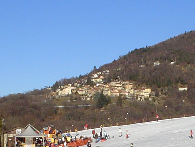
Novaggio is a charming municipality located in the canton of Ticino in southern Switzerland, known for its beautiful landscapes and great hiking opportunities. It is situated near the picturesque Lake Lugano and surrounded by the foothills of the Swiss Alps, making it an excellent destination for outdoor enthusiasts.
Hiking Trails in Novaggio
-
Local Trails: Novaggio offers a network of well-marked hiking trails that vary in difficulty. You can find routes suitable for family outings as well as more challenging paths for experienced hikers.
-
Scenic Views: Many trails provide stunning panoramic views of Lake Lugano, the surrounding mountains, and the charming villages in the region. The vistas can be particularly breathtaking during sunrise or sunset.
-
Nature & Wildlife: The area around Novaggio is rich in biodiversity, including different species of flora and fauna. Hikers may encounter local wildlife and enjoy the natural beauty of the landscape.
-
Historical Sites: Some hiking trails may also lead to historical sites or areas of cultural significance, allowing hikers to combine outdoor activity with a bit of history.
-
Accessibility: The trails are generally accessible during the warmer months, typically from late spring to early autumn. It’s advisable to check local conditions as some trails may be affected by weather or maintenance work.
Tips for Hiking in Novaggio
-
Prepare Adequately: Wear appropriate hiking gear, including sturdy boots and dress in layers. The weather in the mountains can change rapidly.
-
Stay Hydrated: Always bring enough water, especially on longer hikes.
-
Trail Maps: While the trails are well-marked, having a map or a hiking app on your smartphone can help keep you oriented.
-
Respect Nature: Stay on marked paths, carry out any litter, and follow local guidelines to preserve the natural environment.
-
Inform Someone: If you're going on a long hike, inform a friend or family member about your plans.
Conclusion
Hiking in Novaggio offers a perfect blend of natural beauty, outdoor adventure, and tranquility. Whether you are a novice hiker or an experienced explorer, Novaggio has something to offer for everyone. Enjoy your hikes and the stunning landscapes that Ticino has to offer!
- Страна:

- Почтовый код: 6986
- Телефонный код: 091
- Код автомобильного номера: TI
- Координаты: 46° 1' 7" N, 8° 50' 42" E


- GPS треки (wikiloc): [Ссылка]
- Высота над уровнем моря: 833 м m
- Площадь: 4.4 кв.км
- Население: 829
- Веб сайт: http://www.novaggio.ch
- Википедия английская: wiki(en)
- Википедия национальная: wiki(de)
- Хранилище Wikidata: Wikidata: Q67878
- Катеория в википедии: [Ссылка]
- код Freebase: [/m/0gz72v]
- код GeoNames: Альт: [7286661]
- код VIAF: Альт: [132554234]
- ID отношения в OpenStreetMap: [1684728]
- код LCNAF: Альт: [n82222627]
- идентификатор HDS: [2192]
- код швейцарского муниципалитета: [5207]
Граничит с регионами:
Думенца
- коммуна Италии
Hiking in Думенца
Dumenza is a charming town located in the Lombardy region of Italy, near the border with Switzerland. It's situated in a picturesque area that offers a variety of hiking opportunities, particularly due to its proximity to the beautiful Val Veddasca and Lake Maggiore....
- Страна:

- Почтовый код: 21010
- Телефонный код: 0332
- Код автомобильного номера: VA
- Координаты: 46° 1' 0" N, 8° 47' 0" E
- GPS треки (wikiloc): [Ссылка]
- Высота над уровнем моря: 411 м m
- Площадь: 18.4 кв.км
- Население: 1484
- Веб сайт: [Ссылка]
Aranno
Hiking in Aranno
Aranno is a charming village located in the canton of Ticino, Switzerland. It offers a fantastic setting for hiking enthusiasts, with beautiful landscapes and a variety of trails that cater to different skill levels. Here are some key points about hiking in Aranno:...
- Страна:
- Почтовый код: 6994
- Телефонный код: 91
- Код автомобильного номера: TI
- Координаты: 46° 1' 0" N, 8° 52' 0" E
- GPS треки (wikiloc): [Ссылка]
- Высота над уровнем моря: 707 м m
- Площадь: 2.58 кв.км
- Население: 375
- Веб сайт: [Ссылка]


Miglieglia
Hiking in Miglieglia
Miglieglia is a picturesque village located in the Ticino region of Switzerland, nestled in the foothills of the Swiss Alps. It’s an excellent destination for hiking enthusiasts due to its beautiful landscapes, varied terrain, and stunning views. Here’s an overview of hiking in Miglieglia:...
- Страна:
- Почтовый код: 6986
- Телефонный код: 091
- Код автомобильного номера: TI
- Координаты: 46° 1' 53" N, 8° 50' 58" E
- GPS треки (wikiloc): [Ссылка]
- Высота над уровнем моря: 971 м m
- Площадь: 5.13 кв.км
- Население: 311
- Веб сайт: [Ссылка]


Astano
Hiking in Astano
Astano is a charming municipality located in the canton of Ticino in Switzerland, known for its picturesque landscape, serene environment, and proximity to Lake Lugano. While it may not be as well-known as some other destinations in Switzerland, it offers some beautiful hiking opportunities for both casual walkers and more experienced hikers....
- Страна:
- Почтовый код: 6999
- Телефонный код: 091
- Код автомобильного номера: TI
- Координаты: 46° 0' 45" N, 8° 48' 59" E
- GPS треки (wikiloc): [Ссылка]
- Высота над уровнем моря: 631 м m
- Площадь: 3.8 кв.км
- Население: 303
- Веб сайт: [Ссылка]


Bedigliora
Hiking in Bedigliora
Bedigliora is a charming village located in the canton of Ticino in Switzerland. It offers beautiful landscapes, serene environments, and a variety of hiking opportunities. Here are some highlights about hiking in and around Bedigliora:...
- Страна:
- Почтовый код: 6981
- Телефонный код: 091
- Код автомобильного номера: TI
- Координаты: 46° 0' 0" N, 8° 51' 0" E
- GPS треки (wikiloc): [Ссылка]
- Высота над уровнем моря: 617 м m
- Площадь: 2.5 кв.км
- Население: 634
- Веб сайт: [Ссылка]


Curio
Hiking in Curio
Curio is a small village located in the Ticino canton of Switzerland, known for its stunning natural beauty and proximity to the Lugano area. The region offers a variety of hiking trails suitable for different skill levels, making it a great destination for outdoor enthusiasts....
- Страна:
- Почтовый код: 6986
- Телефонный код: 091
- Код автомобильного номера: TI
- Координаты: 46° 0' 9" N, 8° 52' 27" E
- GPS треки (wikiloc): [Ссылка]
- Высота над уровнем моря: 558 м m
- Площадь: 2.84 кв.км
- Население: 544
- Веб сайт: [Ссылка]