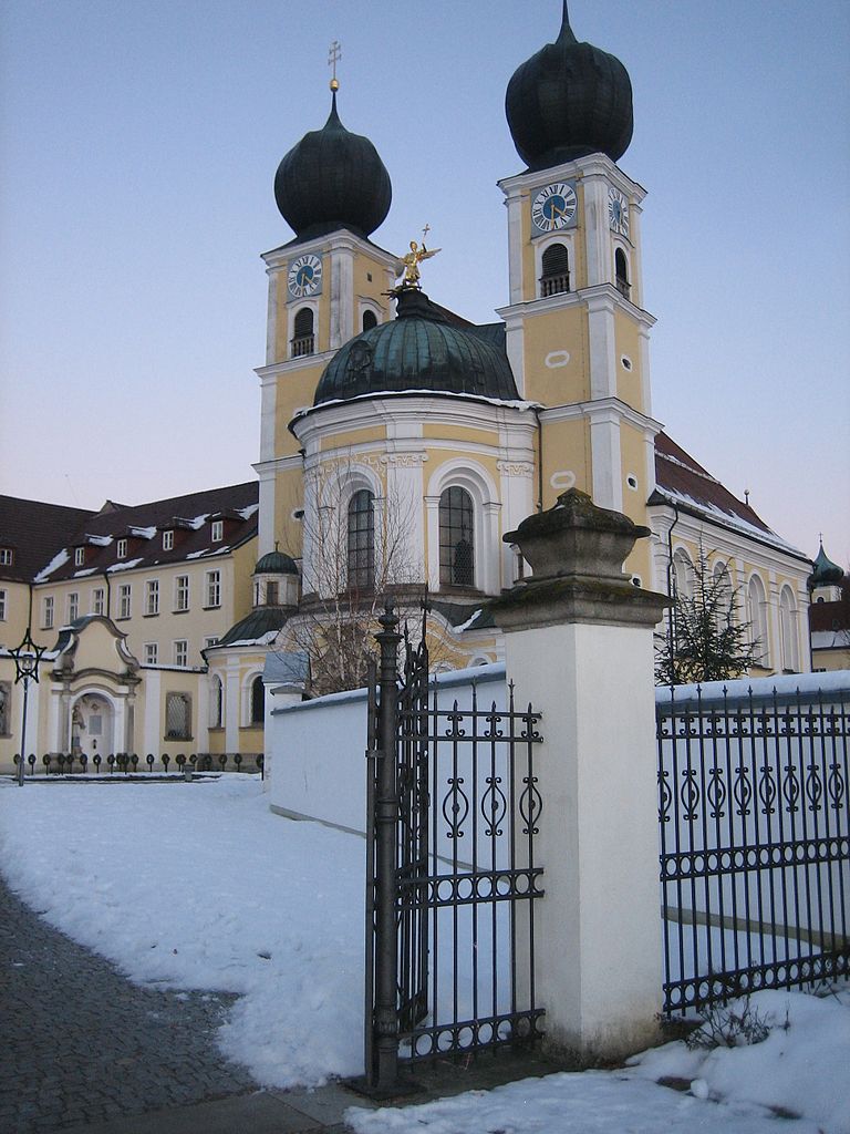
Бернрид (Bernried, Bernried)

 Hiking in Бернрид
Bernried, located in Bavaria, Germany, is an excellent destination for hiking enthusiasts. Nestled near the beautiful Starnberger See (Lake Starnberg), it offers a mix of picturesque landscapes, serene lakeshores, and forested hills. Here are some highlights to consider when hiking in Bernried:
Nature and Scenery
- Lake Starnberg: The shores of the lake provide lovely scenic views and a refreshing backdrop for various hiking trails. You can enjoy paths that take you around the lake, offering beautiful vistas and opportunities for wildlife watching.
- Forested Areas: The surrounding oak and beech forests create a peaceful atmosphere, perfect for a relaxing hike. These wooded areas are often less crowded, allowing for a more intimate experience with nature.
Hiking Trails
- Circular Trails: There are several well-marked circular trails in and around Bernried, catering to different skill levels. They range from easy walks suitable for families to more challenging routes for experienced hikers.
- Bavarian Forest Trails: Access to the broader Bavarian hiking trail network allows for extended hikes into the scenic countryside, including views of the Alps on clear days.
Points of Interest
- Bernried Church: While hiking, you can visit the local church, known for its beautiful architecture and surrounding gardens.
- Museums and Culture: Consider exploring local culture by visiting art galleries and the nearby Buchheim Museum of Phantasy, which features works related to the region.
Best Time to Hike
- Spring and Autumn: These seasons typically offer pleasant temperatures and stunning foliage, making them ideal for hikes.
- Summer: While warmer, summer can bring more crowds to popular trails and lake areas, so plan your hikes early in the day to beat the heat and the visitors.
Practical Tips
- Footwear: Wearing sturdy, comfortable hiking boots is essential due to varying trail conditions.
- Water and Snacks: Always carry enough water and snacks, especially on longer hikes.
- Weather Awareness: Check the weather forecast before heading out, as conditions can change rapidly in the mountains.
Whether you're looking for a leisurely stroll by the lake or a more challenging hike through the hills, Bernried provides a charming backdrop for all types of hiking adventures. Enjoy your time in this beautiful part of Bavaria!
- Страна:

- Почтовый код: 94374; 94505
- Телефонный код: 09905
- Код автомобильного номера: DEG
- Координаты: 48° 55' 0" N, 12° 52' 0" E


- GPS треки (wikiloc): [Ссылка]
- Высота над уровнем моря: 382 м m
- Площадь: 39.47 кв.км
- Население: 4772
- Веб сайт: http://www.bernried-niederbayern.de/
- Википедия русская: wiki(ru)
- Википедия английская: wiki(en)
- Википедия национальная: wiki(de)
- Хранилище Wikidata: Wikidata: Q260902
- Катеория в википедии: [Ссылка]
- код Freebase: [/m/02q0_rx]
- код GeoNames: Альт: [6556455]
- ID отношения в OpenStreetMap: [959818]
- код GND: Альт: [4208666-8]
- Bavarikon ID: [ODB_A00001435]
- идентификатор муниципалитетов в Германии: 09271116
Граничит с регионами:

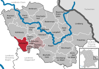
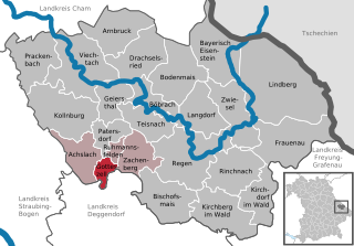
Акслах
Hiking in Акслах
Achslach is a beautiful area located in Bavaria, Germany, known for its stunning natural landscapes, dense forests, and scenic hiking trails. Here are some highlights and tips for hiking in and around Achslach:...
- Страна:
- Почтовый код: 94250
- Телефонный код: 09929
- Код автомобильного номера: REG
- Координаты: 48° 58' 18" N, 12° 56' 6" E
- GPS треки (wikiloc): [Ссылка]
- Высота над уровнем моря: 595 м m
- Площадь: 30.05 кв.км
- Население: 1083
- Веб сайт: [Ссылка]

Готтесцелль
Hiking in Готтесцелль
Gotteszell, located in the Bavarian Forest of Germany, is a charming destination for hiking enthusiasts. The area is characterized by its lush forests, rolling hills, and stunning panoramic views, making it ideal for outdoor activities. Here’s a brief overview of what to expect while hiking in Gotteszell:...
- Страна:
- Почтовый код: 94239
- Телефонный код: 09929
- Код автомобильного номера: REG
- Координаты: 48° 58' 0" N, 12° 58' 0" E
- GPS треки (wikiloc): [Ссылка]
- Высота над уровнем моря: 510 м m
- Площадь: 9.22 кв.км
- Население: 1167
- Веб сайт: [Ссылка]
Меттен
Hiking in Меттен
Metten is a charming town in Bavaria, Germany, known for its beautiful landscapes and outdoor activities, including hiking. The town is surrounded by lush forests, rolling hills, and the Danube River, making it an ideal location for nature lovers and hikers of all skill levels....
- Страна:
- Почтовый код: 94526
- Телефонный код: 0991
- Код автомобильного номера: DEG
- Координаты: 48° 52' 0" N, 12° 55' 0" E
- GPS треки (wikiloc): [Ссылка]
- Высота над уровнем моря: 318 м m
- Площадь: 11.95 кв.км
- Население: 4191
- Веб сайт: [Ссылка]

Оффенберг
Hiking in Оффенберг
Offenberg is a small town located in Bavaria, Germany, known for its beautiful landscapes and outdoor activities, including hiking. Here are some highlights about hiking in that area:...
- Страна:
- Почтовый код: 94560
- Телефонный код: 09906; 09962; 09905; 0991
- Код автомобильного номера: DEG
- Координаты: 48° 52' 0" N, 12° 52' 0" E
- GPS треки (wikiloc): [Ссылка]
- Высота над уровнем моря: 346 м m
- Площадь: 23.76 кв.км
- Население: 3258
- Веб сайт: [Ссылка]

Графлинг
Hiking in Графлинг
Hiking in Grafling, located in Bavaria, Germany, offers a variety of scenic trails and beautiful landscapes, making it an excellent destination for outdoor enthusiasts. Here are some highlights and tips for hiking in the area:...
- Страна:
- Почтовый код: 94539
- Телефонный код: 0991
- Код автомобильного номера: DEG
- Координаты: 48° 53' 40" N, 12° 58' 30" E
- GPS треки (wikiloc): [Ссылка]
- Высота над уровнем моря: 433 м m
- Площадь: 46.32 кв.км
- Население: 2738
- Веб сайт: [Ссылка]


Шварцах
- муниципалитет в Германии, Бавария
Hiking in Шварцах
Schwarzach, located in Lower Bavaria, Germany, is a quaint area known for its beautiful landscapes, lush forests, and scenic trails. Here are some key points about hiking in the area:...
- Страна:
- Почтовый код: 94374
- Телефонный код: 09962
- Код автомобильного номера: SR
- Координаты: 48° 55' 0" N, 12° 49' 0" E
- GPS треки (wikiloc): [Ссылка]
- Высота над уровнем моря: 361 м m
- Площадь: 33.22 кв.км
- Население: 2263
- Веб сайт: [Ссылка]