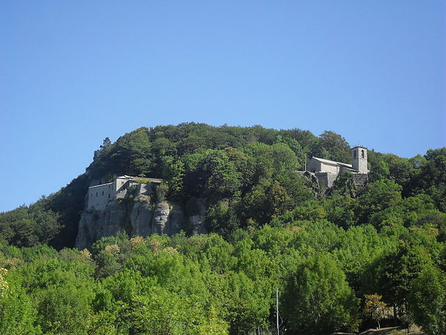
Биббьена (Bibbiena, Bibbiena)
.svg)
- коммуна Италии
 Hiking in Биббьена
Bibbiena, located in the Casentino area of Tuscany, Italy, is a fantastic destination for hiking enthusiasts. The region is characterized by its lush landscapes, rolling hills, and rich history. Here are some highlights to consider when hiking in and around Bibbiena:
Trails and Natural Features
-
Casentino Forests, Monte Falterona, and Campigna National Park: This large national park offers numerous trails of varying difficulties, from easy paths to challenging hikes. The park is known for its diverse flora and fauna, stunning vistas, and well-preserved natural environment.
-
Historical Trails: Bibbiena and the surrounding area are rich in history, with trails that lead to ancient monasteries and historic sites. These hikes provide a great blend of nature and cultural exploration.
-
Camino di San Francesco: Part of the larger Franciscan Way, this pilgrimage route includes sections that pass through Bibbiena, providing a scenic and spiritual hiking experience.
Hiking Tips
- Best Time to Visit: Spring (April to June) and fall (September to October) are ideal for hiking, offering mild weather and beautiful natural scenery.
- Maps and Guidance: Consider obtaining detailed maps or using a guide to navigate the trails, as some paths may not be well-marked.
- Preparation: Bring plenty of water, snacks, a first aid kit, and weather-appropriate gear. The terrain can vary, so sturdy hiking boots are essential.
Local Attractions
- Bibbiena’s Historic Center: Before or after your hike, take time to explore the charming streets, local shops, and historical buildings of Bibbiena.
- Visit Castagno: Close to Bibbiena, this area offers beautiful landscapes and additional trails that are perfect for exploring.
Conclusion
Hiking in Bibbiena is an excellent way to experience the natural beauty and cultural heritage of Tuscany. Whether you’re seeking a peaceful walk through nature or a challenging hike, the region has something to offer for every level of hiker. Always remember to respect the environment, stay on marked trails, and enjoy the serenity that this beautiful area provides!
- Страна:

- Почтовый код: 52011
- Телефонный код: 0575
- Код автомобильного номера: AR
- Координаты: 43° 41' 51" N, 11° 48' 52" E


- GPS треки (wikiloc): [Ссылка]
- Высота над уровнем моря: 425 м m
- Площадь: 87 кв.км
- Население: 12177
- Веб сайт: http://www.comune.bibbiena.ar.it
- Википедия русская: wiki(ru)
- Википедия английская: wiki(en)
- Википедия национальная: wiki(it)
- Хранилище Wikidata: Wikidata: Q52066
- Катеория в википедии: [Ссылка]
- код Freebase: [/m/071h6r]
- код GeoNames: Альт: [6538584]
- код VIAF: Альт: [144874693]
- ID отношения в OpenStreetMap: [42566]
- идентификатор местоположения ArchINFORM: [45534]
- UN/LOCODE: [ITBBB]
- код ISTAT: 051004
- кадастровый код Италии: A851
Граничит с регионами:


Кастель-Фоконьяно
- коммуна Италии
Hiking in Кастель-Фоконьяно
Castel Focognano is a charming area located in the Tuscany region of Italy, known for its beautiful landscapes and hiking opportunities. Nestled in the Casentino Valley, this location is surrounded by nature, with trails that lead through picturesque forests, rolling hills, and offer stunning views of the surrounding countryside....
- Страна:
- Почтовый код: 52016
- Телефонный код: 0575
- Код автомобильного номера: AR
- Координаты: 43° 39' 12" N, 11° 47' 17" E
- GPS треки (wikiloc): [Ссылка]
- Высота над уровнем моря: 310 м m
- Площадь: 56.63 кв.км
- Население: 3093
- Веб сайт: [Ссылка]

Кьюзи-делла-Верна
- коммуна Италии
Hiking in Кьюзи-делла-Верна
Chiusi della Verna, nestled in the Casentino Forests of Tuscany, Italy, is a fantastic destination for hikers. It offers a blend of natural beauty, historical significance, and a variety of trails catering to different skill levels. Here are some key points to consider when hiking in Chiusi della Verna:...
- Страна:
- Почтовый код: 52010
- Телефонный код: 0575
- Код автомобильного номера: AR
- Координаты: 43° 41' 54" N, 11° 56' 10" E
- GPS треки (wikiloc): [Ссылка]
- Высота над уровнем моря: 960 м m
- Площадь: 102.33 кв.км
- Население: 2000
- Веб сайт: [Ссылка]


Ортиньяно-Раджоло
- коммуна Италии
Hiking in Ортиньяно-Раджоло
Ortignano Raggiolo is a charming village located in the Tuscany region of Italy, nestled in the Casentino Forests area. It offers a variety of hiking opportunities amid stunning landscapes characterized by picturesque hills, dense forests, and beautiful vistas. Here are some highlights and tips for hiking in and around Ortignano Raggiolo:...
- Страна:
- Почтовый код: 52010
- Телефонный код: 0575
- Код автомобильного номера: AR
- Координаты: 43° 40' 51" N, 11° 44' 59" E
- GPS треки (wikiloc): [Ссылка]
- Высота над уровнем моря: 483 м m
- Площадь: 36.3 кв.км
- Население: 881
- Веб сайт: [Ссылка]


Поппи
- коммуна Италии
Hiking in Поппи
Poppi, located in the Tuscany region of Italy, offers wonderful hiking opportunities that allow you to explore both the natural beauty of the surrounding landscape and the rich history of the area. Here are some highlights for hiking in Poppi:...
- Страна:
- Почтовый код: 52014
- Телефонный код: 0575
- Код автомобильного номера: AR
- Координаты: 43° 44' 9" N, 11° 45' 42" E
- GPS треки (wikiloc): [Ссылка]
- Высота над уровнем моря: 437 м m
- Площадь: 97.09 кв.км
- Население: 6153
- Веб сайт: [Ссылка]

Баньо-ди-Романья
- коммуна регионе Эмилия-Романья, Италия
Hiking in Баньо-ди-Романья
Bagno di Romagna, located in the Emilia-Romagna region of Italy, is a beautiful destination for hiking enthusiasts. Nestled in the Casentino Forests, Monte Falterona, and Campigna National Park, this area offers a variety of trails that cater to different skill levels and interests, all within stunning natural surroundings....
- Страна:
- Почтовый код: 47021
- Телефонный код: 0543
- Код автомобильного номера: FC
- Координаты: 43° 50' 0" N, 11° 58' 0" E
- GPS треки (wikiloc): [Ссылка]
- Высота над уровнем моря: 491 м m
- Площадь: 233.52 кв.км
- Население: 5874
- Веб сайт: [Ссылка]