
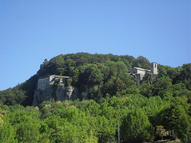
Баньо-ди-Романья (Bagno di Romagna, Bagno di Romagna)
.svg)
- коммуна регионе Эмилия-Романья, Италия
 Hiking in Баньо-ди-Романья
Bagno di Romagna, located in the Emilia-Romagna region of Italy, is a beautiful destination for hiking enthusiasts. Nestled in the Casentino Forests, Monte Falterona, and Campigna National Park, this area offers a variety of trails that cater to different skill levels and interests, all within stunning natural surroundings.
Key Features:
-
Diverse Terrain: The region features a mix of lush forests, rolling hills, rivers, and picturesque landscapes. Hikers can enjoy both relaxing walks and more challenging hikes.
-
Historical Sites: Along some trails, you'll encounter historical landmarks, including ancient churches, hermitages, and points of interest related to local history.
-
Wildlife: The area is part of a protected national park, allowing you to spot various wildlife species including deer, foxes, and a wide variety of birds, making it a great spot for wildlife enthusiasts.
-
Hydrothermal Springs: Bagno di Romagna is known for its thermal baths. Post-hike, visitors can enjoy a soothing soak in the thermal waters, which can be a perfect way to relax your muscles after a long trek.
-
Recommended Trails:
- Sentiero degli Storia: This trail takes you through beautiful landscapes while also offering insights into the local history.
- Monte Falco: A more challenging hike that rewards you with stunning panoramic views of the surrounding mountains and valleys.
- Casentino Forests Trails: These are well-marked and vary in length and difficulty, providing options for all types of hikers.
Tips for Hiking in Bagno di Romagna:
- Season: The best times to hike are during spring and fall when the weather is pleasant and the scenery is picturesque.
- Prepare: Make sure to wear appropriate footwear and clothing. Carry sufficient water and snacks, as well as a map or GPS device.
- Local Guidance: Consider joining local guided tours for added insight into the flora, fauna, and history of the region.
- Respect Nature: Follow Leave No Trace principles to keep this beautiful environment preserved for future hikers.
Hiking in Bagno di Romagna combines natural beauty with cultural richness, making it an excellent destination for nature lovers seeking adventure.
- Страна:

- Почтовый код: 47021
- Телефонный код: 0543
- Код автомобильного номера: FC
- Координаты: 43° 50' 0" N, 11° 58' 0" E


- GPS треки (wikiloc): [Ссылка]
- Высота над уровнем моря: 491 м m
- Площадь: 233.52 кв.км
- Население: 5874
- Веб сайт: http://www.comune.bagnodiromagna.fc.it
- Википедия русская: wiki(ru)
- Википедия английская: wiki(en)
- Википедия национальная: wiki(it)
- Хранилище Wikidata: Wikidata: Q99933
- Катеория в википедии: [Ссылка]
- код Freebase: [/m/0gkljf]
- код GeoNames: Альт: [6540270]
- код VIAF: Альт: [163961794]
- ID отношения в OpenStreetMap: [42639]
- код GND: Альт: [4247330-5]
- место в MusicBrainz: [6855d46b-5753-4f5d-9f05-dcd3b506f44e]
- UN/LOCODE: [ITBRM]
- код ISTAT: 040001
- кадастровый код Италии: A565
Граничит с регионами:


Биббьена
- коммуна Италии
Hiking in Биббьена
Bibbiena, located in the Casentino area of Tuscany, Italy, is a fantastic destination for hiking enthusiasts. The region is characterized by its lush landscapes, rolling hills, and rich history. Here are some highlights to consider when hiking in and around Bibbiena:...
- Страна:
- Почтовый код: 52011
- Телефонный код: 0575
- Код автомобильного номера: AR
- Координаты: 43° 41' 51" N, 11° 48' 52" E
- GPS треки (wikiloc): [Ссылка]
- Высота над уровнем моря: 425 м m
- Площадь: 87 кв.км
- Население: 12177
- Веб сайт: [Ссылка]

Кьюзи-делла-Верна
- коммуна Италии
Hiking in Кьюзи-делла-Верна
Chiusi della Verna, nestled in the Casentino Forests of Tuscany, Italy, is a fantastic destination for hikers. It offers a blend of natural beauty, historical significance, and a variety of trails catering to different skill levels. Here are some key points to consider when hiking in Chiusi della Verna:...
- Страна:
- Почтовый код: 52010
- Телефонный код: 0575
- Код автомобильного номера: AR
- Координаты: 43° 41' 54" N, 11° 56' 10" E
- GPS треки (wikiloc): [Ссылка]
- Высота над уровнем моря: 960 м m
- Площадь: 102.33 кв.км
- Население: 2000
- Веб сайт: [Ссылка]


Поппи
- коммуна Италии
Hiking in Поппи
Poppi, located in the Tuscany region of Italy, offers wonderful hiking opportunities that allow you to explore both the natural beauty of the surrounding landscape and the rich history of the area. Here are some highlights for hiking in Poppi:...
- Страна:
- Почтовый код: 52014
- Телефонный код: 0575
- Код автомобильного номера: AR
- Координаты: 43° 44' 9" N, 11° 45' 42" E
- GPS треки (wikiloc): [Ссылка]
- Высота над уровнем моря: 437 м m
- Площадь: 97.09 кв.км
- Население: 6153
- Веб сайт: [Ссылка]
Меркато-Сарачено
- коммуна Италии
Hiking in Меркато-Сарачено
Mercato Saraceno is a charming town located in the Emilia-Romagna region of Italy, specifically in the province of Forlì-Cesena. It’s surrounded by beautiful landscapes, including rolling hills, forests, and stunning vistas, making it a great place for hiking enthusiasts....
- Страна:
- Почтовый код: 47025
- Телефонный код: 0547
- Код автомобильного номера: FC
- Координаты: 43° 57' 0" N, 12° 12' 0" E
- GPS треки (wikiloc): [Ссылка]
- Высота над уровнем моря: 134 м m
- Площадь: 99.33 кв.км
- Население: 6837
- Веб сайт: [Ссылка]


Санта-София
- коммуна в регионе Эмилия-Романья, Италия
Hiking in Санта-София
Santa Sofia, located in the province of Forlì-Cesenatico in the Emilia-Romagna region of Italy, offers beautiful hiking opportunities set in a picturesque natural landscape. Nestled in the foothills of the Apennines, the area is characterized by lush forests, rolling hills, and stunning views, making it an attractive destination for outdoor enthusiasts....
- Страна:
- Почтовый код: 47018
- Телефонный код: 0543
- Код автомобильного номера: FC
- Координаты: 43° 57' 0" N, 11° 54' 0" E
- GPS треки (wikiloc): [Ссылка]
- Высота над уровнем моря: 257 м m
- Площадь: 148.56 кв.км
- Население: 4120
- Веб сайт: [Ссылка]


Сарсина
- коммуна Италии
Hiking in Сарсина
Sarsina, located in the Emilia-Romagna region of Italy, is a charming town that offers various hiking opportunities amidst beautiful landscapes and rich historical and cultural heritage. The surrounding area includes the Appenine Mountains, which provide a variety of trails suitable for different skill levels....
- Страна:
- Почтовый код: 47027
- Телефонный код: 0547
- Код автомобильного номера: FC
- Координаты: 43° 55' 0" N, 12° 9' 0" E
- GPS треки (wikiloc): [Ссылка]
- Высота над уровнем моря: 243 м m
- Площадь: 100 кв.км
- Население: 3662
- Веб сайт: [Ссылка]
Вергерето
- коммуна регионе Эмилия-Романья, Италия
Hiking in Вергерето
Verghereto, located in the province of Forlì-Cesena in Emilia-Romagna, Italy, is an excellent destination for hiking enthusiasts. Nestled in the Apennine Mountains, the region is characterized by its stunning landscapes, lush forests, and a variety of trails suitable for different skill levels....
- Страна:
- Почтовый код: 47028
- Телефонный код: 0543
- Код автомобильного номера: FC
- Координаты: 43° 48' 0" N, 11° 58' 0" E
- GPS треки (wikiloc): [Ссылка]
- Высота над уровнем моря: 812 м m
- Площадь: 117.9 кв.км
- Население: 1860
- Веб сайт: [Ссылка]