Bister (Bister VS)

 Hiking in Bister
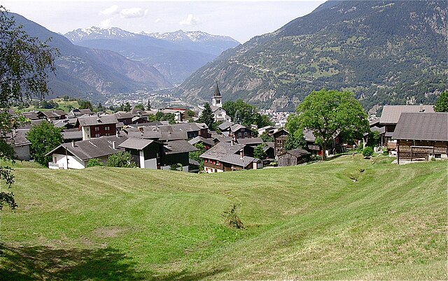
Bister, located in the heart of the Swiss Alps, is a beautiful destination for hiking enthusiasts. It offers stunning mountain landscapes, diverse flora and fauna, and well-marked trails suitable for various skill levels.
Key Points about Hiking in Bister, Switzerland:
Trails:
- Beginner to Advanced: There’s a range of trails from easy walks suitable for families to challenging hikes for experienced trekkers.
- Scenic Routes: Many trails provide breathtaking views of the surrounding peaks, valleys, and sometimes glacial lakes.
- Loop Trails: Some paths are designed as loops, allowing hikers to enjoy a diverse range of scenery without retracing their steps.
Seasons:
- Summer Hiking: Typically, late spring to early autumn is the best time for hiking, as temperatures are mild and trails are mostly clear of snow.
- Winter Hiking: Some trails are accessible in winter for snowshoeing or winter hiking, offering a completely different experience.
Flora and Fauna:
- Rich Biodiversity: Hikers can enjoy a variety of wildflowers in summer and may spot local wildlife, such as ibex, chamois, and various bird species.
Preparation:
- Weather Considerations: Weather can change rapidly in the mountains; it's essential to check forecasts and be prepared with suitable clothing and gear.
- Essential Gear: Sturdy hiking boots, a map or GPS device, water, snacks, and a first-aid kit are all recommended.
Safety Tips:
- Stay on Marked Trails: To preserve the environment and ensure personal safety, it's crucial to stick to established paths.
- Hiking in Groups: It’s usually safer and more enjoyable to hike in groups rather than alone.
Points of Interest:
- Local Culture: While hiking, don’t miss the chance to experience local Swiss culture, such as traditional chalets and regional cuisine at mountain huts.
- Photography Opportunities: The picturesque landscapes offer ample opportunities for photographers, especially at sunrise or sunset.
Whether you’re seeking a peaceful walk surrounded by nature or a strenuous climb to catch unparalleled views, Bister has something to offer every hiking enthusiast. Always remember to check local maps, trail conditions, and regulations before heading out. Enjoy your hike!
- Страна:

- Почтовый код: 3983
- Телефонный код: 027
- Код автомобильного номера: VS
- Координаты: 46° 22' 0" N, 8° 4' 0" E


- GPS треки (wikiloc): [Ссылка]
- Высота над уровнем моря: 1896 м m
- Площадь: 5.8 кв.км
- Население: 32
- Википедия английская: wiki(en)
- Википедия национальная: wiki(de)
- Хранилище Wikidata: Wikidata: Q70351
- Катеория в википедии: [Ссылка]
- код Freebase: [/m/0h6c6x]
- код GeoNames: Альт: [8533570]
- ID отношения в OpenStreetMap: [1685277]
- идентификатор HDS: [2747]
- код швейцарского муниципалитета: [6172]
Граничит с регионами:
Termen
Hiking in Termen
Termen is a small municipality located in the southern region of Switzerland, known for its beautiful alpine landscapes. While it's not one of the most widely recognized hiking destinations compared to its neighbors, it does offer some excellent opportunities for hikers seeking tranquility and stunning views....
- Страна:
- Почтовый код: 3912
- Телефонный код: 027
- Код автомобильного номера: VS
- Координаты: 46° 19' 0" N, 8° 1' 0" E
- GPS треки (wikiloc): [Ссылка]
- Высота над уровнем моря: 925 м m
- Площадь: 18.8 кв.км
- Население: 913
- Веб сайт: [Ссылка]


Grengiols
Hiking in Grengiols
Grengiols is a charming village located in the Valais region of Switzerland, known for its stunning landscapes and diverse hiking opportunities. Nestled in the mountains, it offers a unique blend of natural beauty, traditional Swiss architecture, and a peaceful atmosphere. Here are some key points about hiking in Grengiols:...
- Страна:
- Почтовый код: 3993
- Телефонный код: 027
- Код автомобильного номера: VS
- Координаты: 46° 22' 0" N, 8° 6' 0" E
- GPS треки (wikiloc): [Ссылка]
- Высота над уровнем моря: 984 м m
- Площадь: 58.46 кв.км
- Население: 432
- Веб сайт: [Ссылка]