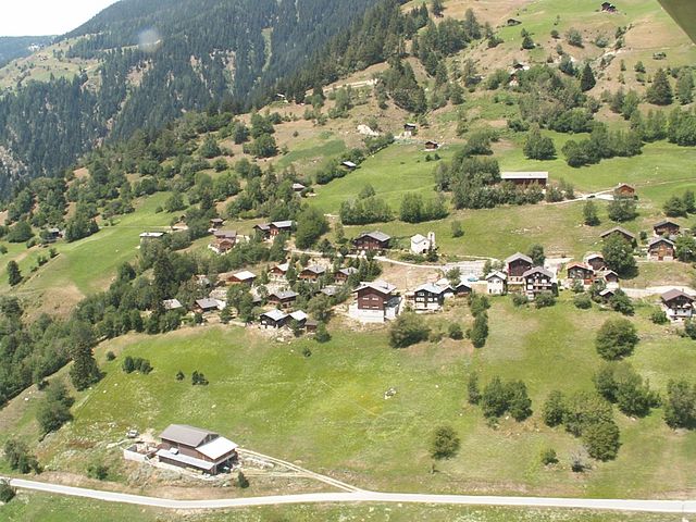
Östlich Raron District (Bezirk Östlich Raron)

 Hiking in Östlich Raron District
Östlich Raron, located in the Valais region of Switzerland, offers a unique and beautiful hiking experience characterized by stunning alpine scenery, diverse landscapes, and a variety of trails suitable for different skill levels. Here are some highlights and tips for hiking in this area:
Main Hiking Trails
-
Gornergrat Trail: A popular route that leads you to the Gornergrat ridge, providing breathtaking views of the Matterhorn and Monte Rosa. The trail is well-marked and varies in difficulty.
-
Bietschhorn Trail: This trail offers a more challenging hike with steep sections, but the panoramic views from the summit are well worth the effort.
-
Raron to Leukerbad: This is a scenic trail connecting Raron to the spa town of Leukerbad. It features a mix of forest trails and open spaces with beautiful views.
Flora and Fauna
The Östlich Raron area is rich in biodiversity, with opportunities to see a wide variety of alpine flowers, plants, and wildlife. Keep an eye out for marmots, chamois, and a variety of bird species.
Best Time to Hike
The best months for hiking in Östlich Raron are from late spring to early autumn (May to October). This allows you to experience the trails in good weather and enjoy the full bloom of wildflowers. However, some trails may still have snow in early spring.
Hiking Tips
- Preparation: Always check weather conditions and trail requirements before heading out. Carry a map or GPS device, as some trails can be less marked.
- Footwear: Good hiking boots are essential, as the terrain can vary from well-maintained paths to rocky and steep sections.
- Hydration and Snacks: Bring plenty of water and high-energy snacks to keep you fueled during your hike.
- Safety: Inform someone of your intended route and expected return time, especially if you are hiking alone.
Accommodations and Amenities
Raron offers various accommodations, including hotels and guesthouses. You can also find restaurants and cafes in the area where you can relax and replenish after a long hike.
Overall, hiking in Östlich Raron can be a rich and rewarding experience, with plenty of opportunities for adventure and exploration in the Swiss Alps. Enjoy your hike!
- Страна:

- Столица: Mörel-Filet
- Код автомобильного номера: VS
- Координаты: 46° 20' 0" N, 8° 3' 1" E


- GPS треки (wikiloc): [Ссылка]
- Площадь: 127.2 кв.км
- Википедия английская: wiki(en)
- Википедия национальная: wiki(de)
- Хранилище Wikidata: Wikidata: Q306887
- Катеория в википедии: [Ссылка]
- код Freebase: [/m/076zk9d]
- код GeoNames: Альт: [2659271]
- идентификатор местоположения ArchINFORM: [45090]
- идентификатор HDS: [8402]
Включает регионы:


Grengiols
Hiking in Grengiols
Grengiols is a charming village located in the Valais region of Switzerland, known for its stunning landscapes and diverse hiking opportunities. Nestled in the mountains, it offers a unique blend of natural beauty, traditional Swiss architecture, and a peaceful atmosphere. Here are some key points about hiking in Grengiols:...
- Страна:
- Почтовый код: 3993
- Телефонный код: 027
- Код автомобильного номера: VS
- Координаты: 46° 22' 0" N, 8° 6' 0" E
- GPS треки (wikiloc): [Ссылка]
- Высота над уровнем моря: 984 м m
- Площадь: 58.46 кв.км
- Население: 432
- Веб сайт: [Ссылка]


Bitsch
Hiking in Bitsch
Bitsch is a charming village located in the Valais region of Switzerland, nestled in the heart of the Swiss Alps. It's an excellent base for hiking enthusiasts, offering a variety of trails that showcase the stunning natural beauty of the area....
- Страна:
- Почтовый код: 3982
- Телефонный код: 027
- Код автомобильного номера: VS
- Координаты: 46° 20' 0" N, 8° 0' 0" E
- GPS треки (wikiloc): [Ссылка]
- Высота над уровнем моря: 806 м m
- Площадь: 4.1 кв.км
- Население: 976
- Веб сайт: [Ссылка]


Betten
Hiking in Betten
Betten is a picturesque village located in the Valais region of Switzerland, known for its stunning alpine scenery and outdoor activities, including hiking. Here are some key points about hiking in Betten:...
- Страна:
- Почтовый код: 3991
- Телефонный код: 027
- Код автомобильного номера: VS
- Координаты: 46° 22' 0" N, 8° 4' 0" E
- GPS треки (wikiloc): [Ссылка]
- Высота над уровнем моря: 1192 м m
- Площадь: 26.4 кв.км
- Веб сайт: [Ссылка]


Riederalp
Hiking in Riederalp
Riederalp, located in the Swiss Alps in the Valais canton, is a fantastic destination for hikers of all skill levels. Nestled at an elevation of about 1,900 meters, it offers stunning views of the surrounding mountains, including the iconic Matterhorn and the Aletsch Glacier, which is the largest glacier in the Alps and a UNESCO World Heritage site....
- Страна:
- Почтовый код: 3987
- Телефонный код: 027
- Код автомобильного номера: VS
- Координаты: 46° 23' 0" N, 8° 2' 0" E
- GPS треки (wikiloc): [Ссылка]
- Высота над уровнем моря: 1905 м m
- Площадь: 21.04 кв.км
- Население: 481
- Веб сайт: [Ссылка]

Martisberg
Hiking in Martisberg
Martisberg is a lovely area for hiking, located in the Sierra Nevada region of California, near Lake Tahoe. This area features a mix of beautiful scenery, diverse wildlife, and various trails that cater to different skill levels. Here are some key points to consider when planning your hike in Martisberg:...
- Страна:
- Почтовый код: 3994
- Телефонный код: 027
- Код автомобильного номера: VS
- Координаты: 46° 23' 0" N, 8° 5' 0" E
- GPS треки (wikiloc): [Ссылка]
- Высота над уровнем моря: 1367 м m
- Площадь: 3.0 кв.км
Bister
Hiking in Bister
Bister, located in the heart of the Swiss Alps, is a beautiful destination for hiking enthusiasts. It offers stunning mountain landscapes, diverse flora and fauna, and well-marked trails suitable for various skill levels....
- Страна:
- Почтовый код: 3983
- Телефонный код: 027
- Код автомобильного номера: VS
- Координаты: 46° 22' 0" N, 8° 4' 0" E
- GPS треки (wikiloc): [Ссылка]
- Высота над уровнем моря: 1896 м m
- Площадь: 5.8 кв.км
- Население: 32


Mörel-Filet
Hiking in Mörel-Filet
Mörel-Filet is a charming area located in the Valais region of Switzerland, nestled in the heart of the Alps. It offers a range of beautiful hiking trails, stunning landscapes, and opportunities for both novice and experienced hikers....
- Страна:
- Почтовый код: 3983
- Телефонный код: 027
- Код автомобильного номера: VS
- Координаты: 46° 21' 25" N, 8° 2' 53" E
- GPS треки (wikiloc): [Ссылка]
- Высота над уровнем моря: 746 м m
- Площадь: 8.4 кв.км
- Население: 678
- Веб сайт: [Ссылка]
Граничит с регионами:


Brig District
Hiking in Brig District
The Brig District, located in the Valais canton of Switzerland, is a picturesque region known for its stunning landscapes, rich history, and a variety of hiking opportunities. Here’s what you need to know about hiking in this beautiful area:...
- Страна:
- Столица: Бриг
- Координаты: 46° 18' 42" N, 7° 59' 6" E
- GPS треки (wikiloc): [Ссылка]
- Высота над уровнем моря: 1478 м m
- Площадь: 434.5 кв.км

Goms District
Hiking in Goms District
Goms District, located in the Valais region of Switzerland, is a stunning destination for hiking enthusiasts. Known for its picturesque landscapes, charming villages, and rich cultural heritage, Goms offers a variety of hiking trails suited for different skill levels....
- Страна:
- Столица: Münster-Geschinen
- Код автомобильного номера: VS
- Координаты: 46° 27' 0" N, 8° 18' 0" E
- GPS треки (wikiloc): [Ссылка]
- Высота над уровнем моря: 1407 м m
- Площадь: 588.3 кв.км