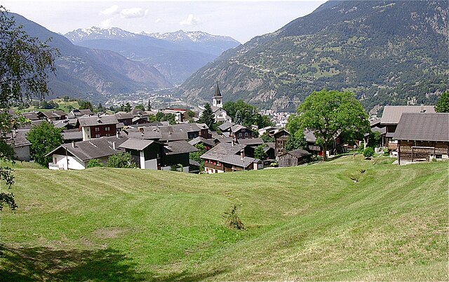
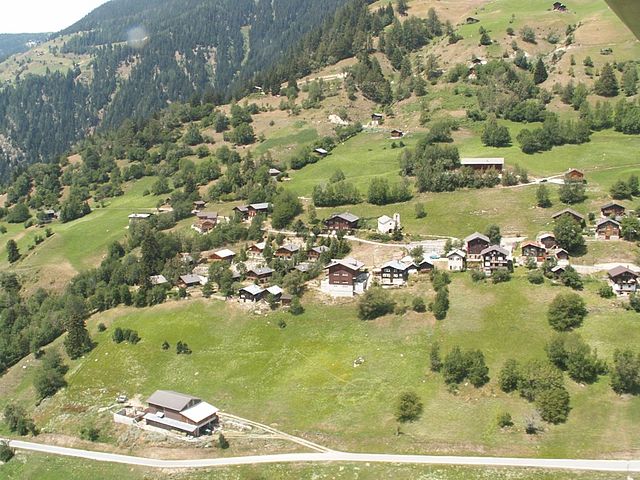
Grengiols (Grengiols)

 Hiking in Grengiols
Grengiols is a charming village located in the Valais region of Switzerland, known for its stunning landscapes and diverse hiking opportunities. Nestled in the mountains, it offers a unique blend of natural beauty, traditional Swiss architecture, and a peaceful atmosphere. Here are some key points about hiking in Grengiols:
Trails and Routes
-
Variety of Difficulty Levels: Grengiols has hiking trails suitable for all levels of hikers. Whether you're a beginner looking for a leisurely trek or an experienced hiker seeking challenging routes, you’ll find trails that fit your skill level.
-
Scenic Paths: Many trails offer breathtaking views of the surrounding mountains, valleys, and landscapes. Look for paths that provide panoramic views over the Rhone Valley and the Swiss Alps.
-
Nature and Wildlife: Hiking in Grengiols allows you to experience the rich biodiversity of the region. Keep an eye out for local flora and fauna, including various wildflowers and potentially some wildlife.
-
Historical and Cultural Sites: Some trails lead to historical sites, such as old farms and churches, adding a cultural dimension to your hiking experience.
Popular Hiking Routes
- Grengiols to the Fiescheralp: This route provides stunning views of the Aletsch Glacier and is feasible for intermediate hikers.
- Gletscherblick Trail: A slightly challenging hike that rewards you with views of glacial landscapes and alpine meadows.
- Local Trails: Explore paths that are popular with locals, taking you through serene forests and alongside sparkling streams.
Best Time to Hike
- Summer and Early Fall (June to October): The best time for hiking in Grengiols when the weather is pleasantly warm, and the trails are generally clear of snow. Peak wildflower season can add vibrant colors to your hikes.
Practical Information
- Map and Guides: It’s advisable to have a detailed hiking map or guidebook to navigate the trails effectively. Local tourism offices can provide valuable resources.
- Weather Conditions: Always check the weather forecast before heading out and be prepared for sudden changes in mountain weather.
- Safety Measures: Carry essentials such as water, snacks, a first-aid kit, and appropriate clothing for changing conditions.
Accessibility
Grengiols is easily accessible by public transport and car, making it a convenient destination for both day hikes and longer adventures.
Overall, hiking in Grengiols is a rewarding experience for nature lovers and offers a serene retreat into the Swiss Alps. Whether you seek adventure or tranquility, you'll find it among the trails of this beautiful region.
- Страна:

- Почтовый код: 3993
- Телефонный код: 027
- Код автомобильного номера: VS
- Координаты: 46° 22' 0" N, 8° 6' 0" E


- GPS треки (wikiloc): [Ссылка]
- Высота над уровнем моря: 984 м m
- Площадь: 58.46 кв.км
- Население: 432
- Веб сайт: http://www.grengiols.ch
- Википедия английская: wiki(en)
- Википедия национальная: wiki(de)
- Хранилище Wikidata: Wikidata: Q67332
- Катеория в википедии: [Ссылка]
- код Freebase: [/m/0h6cf0]
- код GeoNames: Альт: [2660511]
- код VIAF: Альт: [248273342]
- ID отношения в OpenStreetMap: [1685311]
- идентификатор HDS: [2752]
- код швейцарского муниципалитета: [6177]
Граничит с регионами:

Бачено
- коммуна Италии
Hiking in Бачено
Baceno is a charming village located in the Piedmont region of northern Italy, nestled in the Ossola Valley. This area is known for its beautiful landscapes, rich history, and a variety of hiking trails suitable for different skill levels. Here are some highlights about hiking in Baceno:...
- Страна:

- Почтовый код: 28861
- Телефонный код: 0324
- Код автомобильного номера: VB
- Координаты: 46° 16' 0" N, 8° 19' 0" E
- GPS треки (wikiloc): [Ссылка]
- Высота над уровнем моря: 655 м m
- Площадь: 77.27 кв.км
- Население: 900
- Веб сайт: [Ссылка]

Варцо
- коммуна Италии
Hiking in Варцо
Varzo, located in the Piedmont region of Italy, is a beautiful destination for hiking enthusiasts. Nestled in the Val Divedro and surrounded by the breathtaking peaks of the Lepontine Alps, it offers a variety of trails that cater to different skill levels, from beginners to advanced hikers....
- Страна:
- Почтовый код: 28868
- Телефонный код: 0324
- Код автомобильного номера: VB
- Координаты: 46° 12' 27" N, 8° 15' 12" E
- GPS треки (wikiloc): [Ссылка]
- Высота над уровнем моря: 568 м m
- Площадь: 93.77 кв.км
- Население: 2031
- Веб сайт: [Ссылка]
Termen
Hiking in Termen
Termen is a small municipality located in the southern region of Switzerland, known for its beautiful alpine landscapes. While it's not one of the most widely recognized hiking destinations compared to its neighbors, it does offer some excellent opportunities for hikers seeking tranquility and stunning views....
- Страна:
- Почтовый код: 3912
- Телефонный код: 027
- Код автомобильного номера: VS
- Координаты: 46° 19' 0" N, 8° 1' 0" E
- GPS треки (wikiloc): [Ссылка]
- Высота над уровнем моря: 925 м m
- Площадь: 18.8 кв.км
- Население: 913
- Веб сайт: [Ссылка]


Betten
Hiking in Betten
Betten is a picturesque village located in the Valais region of Switzerland, known for its stunning alpine scenery and outdoor activities, including hiking. Here are some key points about hiking in Betten:...
- Страна:
- Почтовый код: 3991
- Телефонный код: 027
- Код автомобильного номера: VS
- Координаты: 46° 22' 0" N, 8° 4' 0" E
- GPS треки (wikiloc): [Ссылка]
- Высота над уровнем моря: 1192 м m
- Площадь: 26.4 кв.км
- Веб сайт: [Ссылка]

Martisberg
Hiking in Martisberg
Martisberg is a lovely area for hiking, located in the Sierra Nevada region of California, near Lake Tahoe. This area features a mix of beautiful scenery, diverse wildlife, and various trails that cater to different skill levels. Here are some key points to consider when planning your hike in Martisberg:...
- Страна:
- Почтовый код: 3994
- Телефонный код: 027
- Код автомобильного номера: VS
- Координаты: 46° 23' 0" N, 8° 5' 0" E
- GPS треки (wikiloc): [Ссылка]
- Высота над уровнем моря: 1367 м m
- Площадь: 3.0 кв.км

Ernen
Hiking in Ernen
Ernen is a picturesque village located in the Valais region of Switzerland, surrounded by stunning alpine landscapes. It is known for its beautiful hiking trails that cater to all skill levels, offering hikers a chance to immerse themselves in nature and enjoy breathtaking views of the Swiss Alps....
- Страна:
- Почтовый код: 3995
- Телефонный код: 027
- Код автомобильного номера: VS
- Координаты: 46° 24' 0" N, 8° 9' 0" E
- GPS треки (wikiloc): [Ссылка]
- Высота над уровнем моря: 1200 м m
- Площадь: 35.4 кв.км
- Население: 501
- Веб сайт: [Ссылка]
Bister
Hiking in Bister
Bister, located in the heart of the Swiss Alps, is a beautiful destination for hiking enthusiasts. It offers stunning mountain landscapes, diverse flora and fauna, and well-marked trails suitable for various skill levels....
- Страна:
- Почтовый код: 3983
- Телефонный код: 027
- Код автомобильного номера: VS
- Координаты: 46° 22' 0" N, 8° 4' 0" E
- GPS треки (wikiloc): [Ссылка]
- Высота над уровнем моря: 1896 м m
- Площадь: 5.8 кв.км
- Население: 32


Mörel-Filet
Hiking in Mörel-Filet
Mörel-Filet is a charming area located in the Valais region of Switzerland, nestled in the heart of the Alps. It offers a range of beautiful hiking trails, stunning landscapes, and opportunities for both novice and experienced hikers....
- Страна:
- Почтовый код: 3983
- Телефонный код: 027
- Код автомобильного номера: VS
- Координаты: 46° 21' 25" N, 8° 2' 53" E
- GPS треки (wikiloc): [Ссылка]
- Высота над уровнем моря: 746 м m
- Площадь: 8.4 кв.км
- Население: 678
- Веб сайт: [Ссылка]