.JPG)
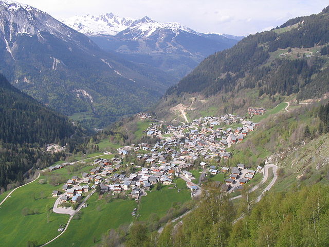
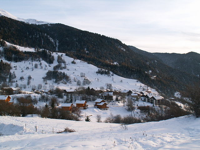
Bozel (Bozel)

- коммуна во Франции
 Hiking in Bozel
Bozel is a charming village located in the Savoie region of the French Alps, close to the renowned ski resorts of Courchevel and Les 3 Vallées. While it's popular for winter sports, Bozel also offers fantastic hiking opportunities in the warmer months, attracting outdoor enthusiasts to explore its beautiful landscapes.
Hiking in Bozel: Key Points
-
Scenic Trails: Bozel is surrounded by breathtaking mountain ranges, offering a variety of hiking trails. You'll find routes that cater to different skill levels, from gentle walks for beginners to challenging hikes for seasoned trekkers.
-
Trail Difficulty: Many trails here range from easy to moderate difficulty, making them accessible for families and casual hikers. More challenging routes, such as ascents toward Glacier de la Vallée des Bellevilles, can also be found, providing options for experienced hikers.
-
Natural Beauty: The hikes around Bozel boast stunning views of the mountains, valleys, and Alpine flora. The area is rich in biodiversity, and you may spot various wildlife, including chamois, marmots, and an array of bird species.
-
Lakes and Waterfalls: The region features beautiful lakes and waterfalls, enhancing your hiking experience. Routes that lead to spots like the Lac de Bozel offer tranquil resting points and picturesque scenery.
-
Access to the Vanoise National Park: A short drive from Bozel, Vanoise National Park presents more ambitious hiking options. The park is known for its dramatic landscapes, diverse ecosystems, and the chance to see ibex and other alpine wildlife.
-
Guided Hikes: For those who prefer a guided experience, various local companies offer organized hiking tours. They can provide insights about the flora, fauna, and geology of the area, making for a richer experience.
-
Best Time to Hike: The best time for hiking in Bozel is from late spring to early autumn (approximately June to September) when the weather is generally milder, and trails are snow-free.
-
Local Amenities: Bozel has amenities such as restaurants, shops, and accommodations to make your stay comfortable. Post-hike, you can relax in quaint eateries enjoying local Savoyard cuisine.
Remember to check the weather conditions before heading out, dress appropriately for the mountains, and stay hydrated. Happy hiking!
- Страна:

- Почтовый код: 73350
- Координаты: 45° 26' 34" N, 6° 38' 56" E


- GPS треки (wikiloc): [Ссылка]
- Площадь: 28.8 кв.км
- Население: 1959
- Веб сайт: http://mairiebozel.fr
- Википедия английская: wiki(en)
- Википедия национальная: wiki(fr)
- Хранилище Wikidata: Wikidata: Q1242293
- Катеория в википедии: [Ссылка]
- код Freebase: [/m/03cc02r]
- код GeoNames: Альт: [3030641]
- номер SIREN: [217300557]
- код BNF: [15273990n]
- код VIAF: Альт: [242712671]
- WOEID: [581520]
- код муниципалитета INSEE: 73055
Граничит с регионами:
Montagny
Hiking in Montagny
Montagny, located in the Savoie region of the French Alps, is an excellent destination for hiking enthusiasts. Nestled amid stunning mountainous scenery, it offers a variety of trails suitable for different skill levels, ranging from leisurely walks to challenging hikes. Here are some highlights about hiking in the area:...
- Страна:
- Почтовый код: 73350
- Координаты: 45° 27' 22" N, 6° 35' 31" E
- GPS треки (wikiloc): [Ссылка]
- Площадь: 13.26 кв.км
- Население: 662

Champagny-en-Vanoise
- коммуна во Франции
Hiking in Champagny-en-Vanoise
Champagny-en-Vanoise is a picturesque village located in the Savoie region of the French Alps, and it serves as a fantastic base for hiking enthusiasts exploring the Vanoise National Park. The area is known for its stunning mountain scenery, diverse flora and fauna, and well-marked hiking trails suitable for all skill levels. Here are some key points about hiking in Champagny-en-Vanoise:...
- Страна:
- Почтовый код: 73350
- Координаты: 45° 27' 16" N, 6° 41' 33" E
- GPS треки (wikiloc): [Ссылка]
- Площадь: 84.96 кв.км
- Население: 605
- Веб сайт: [Ссылка]


La Plagne-Tarentaise
Hiking in La Plagne-Tarentaise
La Plagne-Tarentaise is a stunning hiking destination located in the French Alps, renowned for its scenic beauty, diverse trails, and rich alpine wildlife. Here are some key points to consider if you're planning to hike in this region:...
- Страна:
- Почтовый код: 73210
- Координаты: 45° 33' 16" N, 6° 40' 22" E
- GPS треки (wikiloc): [Ссылка]
- Площадь: 96.07 кв.км


Aime-la-Plagne
Hiking in Aime-la-Plagne
Aime-la-Plagne, located in the French Alps, is a fantastic destination for hiking enthusiasts of all skill levels. Nestled within the Paradiski ski area, this region offers breathtaking views, diverse trails, and a rich Alpine landscape, making it an excellent choice for summer hiking....
- Страна:
- Почтовый код: 73210
- Координаты: 45° 33' 35" N, 6° 39' 6" E
- GPS треки (wikiloc): [Ссылка]
- Площадь: 94.67 кв.км
- Веб сайт: [Ссылка]


Planay, Savoie
Hiking in Planay, Savoie
Planay, located in the Savoie region of the French Alps, is a beautiful destination for hiking enthusiasts. The area is known for its stunning alpine landscapes, picturesque villages, and various hiking trails suitable for different experience levels. Here’s what you can expect when hiking in Planay:...
- Страна:
- Почтовый код: 73350
- Координаты: 45° 25' 23" N, 6° 41' 55" E
- GPS треки (wikiloc): [Ссылка]
- Площадь: 22.41 кв.км
- Население: 412


Saint-Bon-Tarentaise
- коммуна во Франции
Hiking in Saint-Bon-Tarentaise
Saint-Bon-Tarentaise is a stunning region located in the French Alps, known for its breathtaking mountain scenery and a variety of outdoor activities, especially hiking. Here are some key points about hiking in this beautiful area:...
- Страна:
- Почтовый код: 73120
- Координаты: 45° 26' 2" N, 6° 38' 13" E
- GPS треки (wikiloc): [Ссылка]
- Площадь: 58.94 кв.км
- Население: 1901
- Веб сайт: [Ссылка]

Notre-Dame-du-Pré
- коммуна во Франции
Hiking in Notre-Dame-du-Pré
Notre-Dame-du-Pré is a charming Alpine village located in the Savoie region of France, nestled in the breathtaking landscapes of the French Alps. It's a great destination for hikers of various skill levels, offering stunning views and well-marked trails....
- Страна:
- Почтовый код: 73600
- Координаты: 45° 30' 43" N, 6° 35' 37" E
- GPS треки (wikiloc): [Ссылка]
- Площадь: 18.2 кв.км
- Население: 256