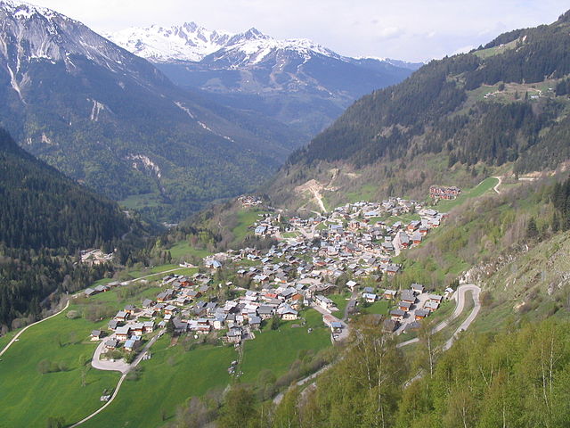
Planay, Savoie (Planay)

 Hiking in Planay, Savoie
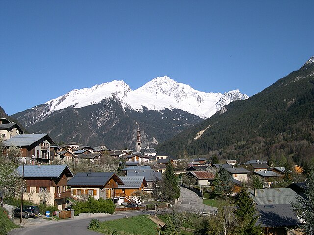
Planay, located in the Savoie region of the French Alps, is a beautiful destination for hiking enthusiasts. The area is known for its stunning alpine landscapes, picturesque villages, and various hiking trails suitable for different experience levels. Here’s what you can expect when hiking in Planay:
Scenic Trails
Planay offers an array of hiking trails that cater to both beginners and experienced hikers. The trails traverse meadows, forests, and mountain ridges, providing breathtaking views of the surrounding mountains and valleys.
Popular Hikes
-
Les Lacs de la Tempête: A moderately difficult trail that leads you to beautiful alpine lakes surrounded by mountains. Perfect for a day hike, especially in the summer when the flowers are in bloom.
-
Sentier des Cîmes: This is a more challenging route that takes you along mountain ridges offering panoramic views. It's advisable for experienced hikers due to its elevation gain.
-
Col de la Forclaz: This hike offers a more leisurely experience, perfect for families and those looking to enjoy the scenery without intense exertion. The path is well marked and relatively easy.
Best Time to Hike
The best time to hike in Planay is during late spring to early autumn (May to September) when the weather is milder and the trails are clear of snow. Be mindful of the weather conditions as they can change rapidly in the mountains.
Safety Tips
- Trail Conditions: Always check the current trail conditions and weather forecasts before heading out.
- Gear: Wear appropriate hiking gear, including sturdy boots, weather-resistant clothing, and carry a daypack with water, snacks, and a first-aid kit.
- Navigation: Make sure to have a map or a GPS device with you. While trails are marked, it's easy to stray off path.
Wildlife and Nature
The area around Planay is rich in biodiversity. Keep an eye out for local wildlife, such as chamois, marmots, and various bird species. The flora is equally impressive, with many alpine flowers and unique plant species.
Accessibility
Planay is typically accessible by car, and parking may be available near popular trailheads. It's best to arrive early during peak season to secure parking.
Local Culture
In addition to hiking, don’t miss out on exploring local Savoyard cuisine in nearby villages, such as fondue or raclette, to replenish your energy after a day on the trails.
Exploring Planay offers a wonderful opportunity to connect with nature, enjoy physical activity, and appreciate the majestic beauty of the French Alps. Happy hiking!
- Страна:

- Почтовый код: 73350
- Координаты: 45° 25' 23" N, 6° 41' 55" E


- GPS треки (wikiloc): [Ссылка]
- Площадь: 22.41 кв.км
- Население: 412
- Википедия английская: wiki(en)
- Википедия национальная: wiki(fr)
- Хранилище Wikidata: Wikidata: Q546671
- Катеория в википедии: [Ссылка]
- код Freebase: [/m/03wcgqs]
- код GeoNames: Альт: [6454651]
- номер SIREN: [217302017]
- код BNF: [15274132h]
- код муниципалитета INSEE: 73201
Граничит с регионами:

Champagny-en-Vanoise
- коммуна во Франции
Hiking in Champagny-en-Vanoise
Champagny-en-Vanoise is a picturesque village located in the Savoie region of the French Alps, and it serves as a fantastic base for hiking enthusiasts exploring the Vanoise National Park. The area is known for its stunning mountain scenery, diverse flora and fauna, and well-marked hiking trails suitable for all skill levels. Here are some key points about hiking in Champagny-en-Vanoise:...
- Страна:
- Почтовый код: 73350
- Координаты: 45° 27' 16" N, 6° 41' 33" E
- GPS треки (wikiloc): [Ссылка]
- Площадь: 84.96 кв.км
- Население: 605
- Веб сайт: [Ссылка]

Bozel
- коммуна во Франции
Hiking in Bozel
Bozel is a charming village located in the Savoie region of the French Alps, close to the renowned ski resorts of Courchevel and Les 3 Vallées. While it's popular for winter sports, Bozel also offers fantastic hiking opportunities in the warmer months, attracting outdoor enthusiasts to explore its beautiful landscapes....
- Страна:
- Почтовый код: 73350
- Координаты: 45° 26' 34" N, 6° 38' 56" E
- GPS треки (wikiloc): [Ссылка]
- Площадь: 28.8 кв.км
- Население: 1959
- Веб сайт: [Ссылка]


Pralognan-la-Vanoise
- коммуна во Франции
Hiking in Pralognan-la-Vanoise
Pralognan-la-Vanoise is a charming village located in the heart of the Vanoise National Park in the French Alps. It is an excellent destination for hiking enthusiasts, offering a diverse range of trails suitable for varying skill levels, as well as breathtaking scenery....
- Страна:
- Почтовый код: 73710
- Координаты: 45° 22' 53" N, 6° 43' 17" E
- GPS треки (wikiloc): [Ссылка]
- Площадь: 88.57 кв.км
- Население: 744
- Веб сайт: [Ссылка]


Saint-Bon-Tarentaise
- коммуна во Франции
Hiking in Saint-Bon-Tarentaise
Saint-Bon-Tarentaise is a stunning region located in the French Alps, known for its breathtaking mountain scenery and a variety of outdoor activities, especially hiking. Here are some key points about hiking in this beautiful area:...
- Страна:
- Почтовый код: 73120
- Координаты: 45° 26' 2" N, 6° 38' 13" E
- GPS треки (wikiloc): [Ссылка]
- Площадь: 58.94 кв.км
- Население: 1901
- Веб сайт: [Ссылка]