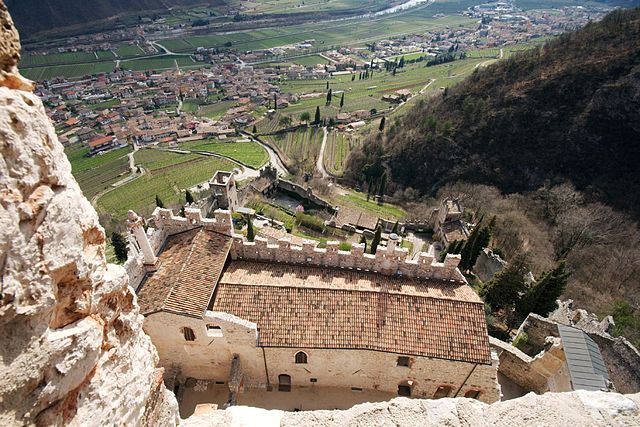
Брентонико (Brentonico, Brentonico)
%202018.svg)
- коммуна Италии
 Hiking in Брентонико
Brentonico is a charming area located in the Trentino region of northern Italy, known for its stunning landscapes, natural beauty, and an array of hiking opportunities. Nestled on the eastern side of Lake Garda, Brentonico offers a diverse range of trails that cater to different skill levels, making it an ideal spot for both beginner and experienced hikers.
Key Highlights for Hiking in Brentonico:
-
Diverse Trails: The area features a variety of hiking trails, from easy walks to challenging treks. The paths often lead through beautiful meadows, forests, and panoramic viewpoints over Lake Garda and the surrounding mountains.
-
Natural Parks: Brentonico is close to the Brentonico Plateau Natural Park, which offers well-marked trails that showcase the local flora and fauna. Hikers can enjoy breathtaking views and the tranquility of nature.
-
Scenic Views: Many trails provide stunning panoramic views of the surrounding Dolomites and the vast landscapes of the Trentino region. Lookout points are frequent, and are perfect spots for photography and relaxation.
-
Rich History: Some hiking routes take you past historical sites, including ancient churches and remnants of old fortifications. This adds a cultural element to your hiking experience.
-
Seasonal Hiking: While summers are popular for hiking due to pleasant temperatures, spring and fall also offer wonderful experiences with fewer crowds. Winter hiking and snowshoeing are options too, as the region often receives snowfall.
-
Local Tips: Always check the weather conditions before heading out and dress in layers. Carry sufficient water, snacks, and a map or GPS device. It's also a good idea to inform someone about your hiking plans.
-
Guided Tours: If you're unsure about the trails or want to enhance your experience, consider joining guided hiking tours. Local guides can provide valuable insights into the natural environment and history of Brentonico.
Notable Hikes:
- Monte Baldo: Accessible from Brentonico, this hike offers spectacular views and various trails to explore.
- Sentiero del Vino e dei Sapori: A wine and flavor trail that combines hiking with the experience of local culinary delights.
- Folgaria and Lavarone: Nearby areas that offer extended hiking routes and connection to larger trail networks.
Conclusion:
Whether you're looking for a leisurely stroll or a more strenuous hike, Brentonico offers a plethora of options filled with natural beauty and cultural significance. Always remember to respect the environment and follow local guidelines to ensure a safe and enjoyable hiking experience!
- Страна:

- Почтовый код: 38060
- Телефонный код: 0464
- Код автомобильного номера: TN
- Координаты: 45° 49' 0" N, 10° 57' 0" E


- GPS треки (wikiloc): [Ссылка]
- Высота над уровнем моря: 698 м m
- Площадь: 57.14 кв.км
- Население: 3961
- Веб сайт: http://www.comune.brentonico.tn.it
- Википедия русская: wiki(ru)
- Википедия английская: wiki(en)
- Википедия национальная: wiki(it)
- Хранилище Wikidata: Wikidata: Q246705
- Катеория в википедии: [Ссылка]
- код Freebase: [/m/0g9y07]
- код GeoNames: Альт: [6537245]
- код VIAF: Альт: [149371252]
- ID отношения в OpenStreetMap: [46105]
- идентификатор местоположения ArchINFORM: [45356]
- код Цифрового атласа Римской империи: [16553]
- код ISTAT: 022025
- кадастровый код Италии: B153
Граничит с регионами:


Ала
- коммуна Италии
Hiking in Ала
Ala, located in the Trentino region of northern Italy, is a great base for hiking enthusiasts. Nestled in the Vallagarina valley, it offers a variety of trails that range from easy walks to more challenging hikes, all set against the backdrop of stunning landscapes, vineyards, and historical sites....
- Страна:
- Почтовый код: 38061
- Телефонный код: 0464
- Код автомобильного номера: TN
- Координаты: 45° 45' 0" N, 11° 0' 0" E
- GPS треки (wikiloc): [Ссылка]
- Высота над уровнем моря: 210 м m
- Площадь: 119.87 кв.км
- Население: 8887
- Веб сайт: [Ссылка]

Авио
- коммуна Италии
Hiking in Авио
Avio, located in the province of Trentino in northern Italy, is a fantastic destination for hiking enthusiasts. Nestled in the picturesque Adige Valley, it offers a variety of trails that cater to different skill levels, all while surrounded by breathtaking landscapes that feature mountains, vineyards, and historical sites....
- Страна:
- Почтовый код: 38063
- Телефонный код: 0464
- Код автомобильного номера: TN
- Координаты: 45° 44' 0" N, 10° 57' 0" E
- GPS треки (wikiloc): [Ссылка]
- Высота над уровнем моря: 131 м m
- Площадь: 68.9 кв.км
- Население: 4091
- Веб сайт: [Ссылка]


Мори
- коммуна Италии
Hiking in Мори
Mori, located in the Trentino region of northern Italy, is a beautiful area for hiking enthusiasts, offering stunning landscapes, diverse trails, and a rich cultural heritage. Here are some aspects to consider when hiking in Mori:...
- Страна:
- Почтовый код: 38065
- Телефонный код: 0464
- Код автомобильного номера: TN
- Координаты: 45° 51' 5" N, 10° 58' 54" E
- GPS треки (wikiloc): [Ссылка]
- Высота над уровнем моря: 204 м m
- Площадь: 40.08 кв.км
- Население: 9846
- Веб сайт: [Ссылка]
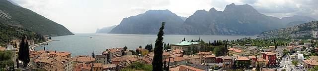

Наго-Торболе
- коммуна Италии
Hiking in Наго-Торболе
Nago–Torbole, located on the northern shore of Lake Garda in Italy, is a popular destination for hikers, offering breathtaking scenery and a variety of trails that cater to different skill levels. The area is characterized by its dramatic landscapes, including steep cliffs, lush forests, and stunning views of the lake....
- Страна:
- Почтовый код: 38069; 38060
- Телефонный код: 0464
- Код автомобильного номера: TN
- Координаты: 45° 52' 33" N, 10° 53' 28" E
- GPS треки (wikiloc): [Ссылка]
- Высота над уровнем моря: 65 м m
- Площадь: 28.39 кв.км
- Население: 2817
- Веб сайт: [Ссылка]


Мальчезине
- коммуна Италии
Hiking in Мальчезине
Malcesine, located on the eastern shore of Lake Garda in Italy, is a stunning destination for hiking enthusiasts. The area is known for its breathtaking landscapes, charming medieval architecture, and a mix of trails suitable for various skill levels. Here are some highlights of hiking in Malcesine:...
- Страна:
- Почтовый код: 37018; 37010
- Телефонный код: 045
- Код автомобильного номера: VR
- Координаты: 45° 46' 0" N, 10° 49' 0" E
- GPS треки (wikiloc): [Ссылка]
- Высота над уровнем моря: 89 м m
- Площадь: 69.29 кв.км
- Население: 3685
- Веб сайт: [Ссылка]