
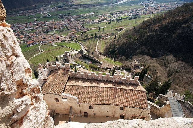
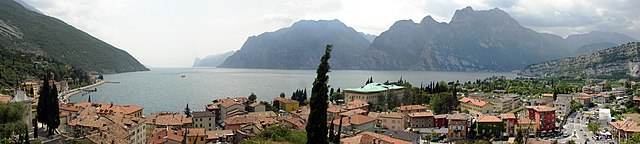
Мальчезине (Malcesine, Malcesine)
.svg)
- коммуна Италии
 Hiking in Мальчезине
Malcesine, located on the eastern shore of Lake Garda in Italy, is a stunning destination for hiking enthusiasts. The area is known for its breathtaking landscapes, charming medieval architecture, and a mix of trails suitable for various skill levels. Here are some highlights of hiking in Malcesine:
Hiking Trails
-
Monte Baldo:
- Trail Starting Point: Many hikes begin from Malcesine, with the Monte Baldo cable car providing easy access to higher elevations.
- Difficulty Levels: There are trails for all levels, from easy walks along the ridges to more challenging hikes with steep climbs.
- Scenery: Offers panoramic views over Lake Garda, wildflower-filled meadows, and varied terrain, including forests and rocky outcrops.
-
Path of the Santuario della Madonna della Cime:
- This is a spiritual trail leading to a sanctuary, featuring multiple viewpoints along the way.
- The trail is moderately difficult and ideal for those who appreciate both nature and cultural elements.
-
Forra del Lupo (Wolf Gorge):
- A unique trail that combines hiking with a bit of adventure. This route goes through a canyon with impressive rock formations and lush vegetation.
- It's more suitable for those seeking a thrilling experience and may require some scrambling.
-
Circuit of Malcesine:
- A loop trail that takes you around the town and offers views of Lake Garda and nearby mountains.
- It's a great option for a leisurely hike, suitable for families or those looking for an easier walk.
Tips for Hiking in Malcesine
- Best Time to Hike: Spring (April to June) and early autumn (September to October) are ideal for hiking, as temperatures are mild and the trails are less crowded.
- Clothing and Gear: Always wear appropriate footwear and carry a light jacket, as weather can change rapidly in the mountains. Sunscreen and water are essential due to the exposed areas.
- Local Guides: If you're unfamiliar with the area, consider hiring a local guide who can share insights about the trails, flora, and fauna, as well as ensuring you stay on safe paths.
- Check Trail Conditions: Before heading out, check the local tourist information for trail conditions and any potential closures due to weather or maintenance.
Other Activities
Apart from hiking, Malcesine offers various outdoor activities including mountain biking, sailing, and paragliding, making it a versatile destination for adventure seekers.
Whether you're looking for a vigorous hike or a peaceful stroll, Malcesine has something to offer, all set against the backdrop of one of Italy's most picturesque lakes. Enjoy your hiking adventure!
- Страна:

- Почтовый код: 37018; 37010
- Телефонный код: 045
- Код автомобильного номера: VR
- Координаты: 45° 46' 0" N, 10° 49' 0" E


- GPS треки (wikiloc): [Ссылка]
- Высота над уровнем моря: 89 м m
- Площадь: 69.29 кв.км
- Население: 3685
- Веб сайт: http://www.comunemalcesine.it/
- Википедия русская: wiki(ru)
- Википедия английская: wiki(en)
- Википедия национальная: wiki(it)
- Хранилище Wikidata: Wikidata: Q47821
- Галерея изображений в википедии: [Ссылка]
- Катеория в википедии: [Ссылка]
- код Freebase: [/m/0gb2ch]
- код GeoNames: Альт: [6536263]
- код VIAF: Альт: [135763510]
- ID отношения в OpenStreetMap: [45871]
- код GND: Альт: [4278614-9]
- код LCNAF: Альт: [n88075032]
- dmoz: Альт: [Regional/Europe/Italy/Veneto/Localities/Malcesine/]
- код ISTAT: 023045
- кадастровый код Италии: E848
Граничит с регионами:

Лимоне-суль-Гарда
- коммуна Италии
Hiking in Лимоне-суль-Гарда
Limone sul Garda is a picturesque town located on the northern shore of Lake Garda in Italy. It is known for its stunning scenery, charming old town, lemon groves, and breathtaking views of the lake and surrounding mountains. Hiking in this area can be a fantastic experience due to the variety of trails available, suitable for different skill levels....
- Страна:
- Почтовый код: 25010
- Телефонный код: 0365
- Код автомобильного номера: BS
- Координаты: 45° 49' 0" N, 10° 47' 0" E
- GPS треки (wikiloc): [Ссылка]
- Высота над уровнем моря: 69 м m
- Площадь: 23.03 кв.км
- Население: 1164
- Веб сайт: [Ссылка]

Тиньяле
- коммуна Италии
Hiking in Тиньяле
Tignale is a beautiful destination located on the western side of Lake Garda in Italy, known for its picturesque landscapes, quaint villages, and numerous hiking trails. It's an ideal location for hikers of all skill levels, offering a variety of routes that range from easy walks to more challenging treks. Here are some key points to consider when hiking in Tignale:...
- Страна:
- Почтовый код: 25080
- Телефонный код: 0365
- Код автомобильного номера: BS
- Координаты: 45° 44' 0" N, 10° 43' 0" E
- GPS треки (wikiloc): [Ссылка]
- Высота над уровнем моря: 555 м m
- Площадь: 45.86 кв.км
- Население: 1228
- Веб сайт: [Ссылка]

Тремозине
- коммуна Италии
Hiking in Тремозине
Tremosine sul Garda is a stunning destination for hiking, located on the cliffs overlooking Lake Garda in northern Italy. This picturesque area is part of the Brescia province and is renowned for its breathtaking views, charming villages, and lush landscapes....
- Страна:
- Почтовый код: 25010
- Телефонный код: 0365
- Код автомобильного номера: BS
- Координаты: 45° 46' 20" N, 10° 45' 30" E
- GPS треки (wikiloc): [Ссылка]
- Высота над уровнем моря: 414 м m
- Площадь: 72.69 кв.км
- Население: 2109
- Веб сайт: [Ссылка]


Рива-дель-Гарда
- коммуна Италии
Hiking in Рива-дель-Гарда
Riva del Garda, located at the northern tip of Lake Garda in Italy, is a fantastic destination for hiking enthusiasts. The area is renowned for its stunning natural landscapes, including mountains, lush forests, and picturesque views of the lake. Here are some key highlights and popular hiking trails around Riva del Garda:...
- Страна:
- Почтовый код: 38066
- Телефонный код: 0464
- Код автомобильного номера: TN
- Координаты: 45° 53' 0" N, 10° 51' 0" E
- GPS треки (wikiloc): [Ссылка]
- Высота над уровнем моря: 70 м m
- Площадь: 40.73 кв.км
- Население: 17370
- Веб сайт: [Ссылка]

Авио
- коммуна Италии
Hiking in Авио
Avio, located in the province of Trentino in northern Italy, is a fantastic destination for hiking enthusiasts. Nestled in the picturesque Adige Valley, it offers a variety of trails that cater to different skill levels, all while surrounded by breathtaking landscapes that feature mountains, vineyards, and historical sites....
- Страна:
- Почтовый код: 38063
- Телефонный код: 0464
- Код автомобильного номера: TN
- Координаты: 45° 44' 0" N, 10° 57' 0" E
- GPS треки (wikiloc): [Ссылка]
- Высота над уровнем моря: 131 м m
- Площадь: 68.9 кв.км
- Население: 4091
- Веб сайт: [Ссылка]


Брентонико
- коммуна Италии
Hiking in Брентонико
Brentonico is a charming area located in the Trentino region of northern Italy, known for its stunning landscapes, natural beauty, and an array of hiking opportunities. Nestled on the eastern side of Lake Garda, Brentonico offers a diverse range of trails that cater to different skill levels, making it an ideal spot for both beginner and experienced hikers....
- Страна:
- Почтовый код: 38060
- Телефонный код: 0464
- Код автомобильного номера: TN
- Координаты: 45° 49' 0" N, 10° 57' 0" E
- GPS треки (wikiloc): [Ссылка]
- Высота над уровнем моря: 698 м m
- Площадь: 57.14 кв.км
- Население: 3961
- Веб сайт: [Ссылка]

Наго-Торболе
- коммуна Италии
Hiking in Наго-Торболе
Nago–Torbole, located on the northern shore of Lake Garda in Italy, is a popular destination for hikers, offering breathtaking scenery and a variety of trails that cater to different skill levels. The area is characterized by its dramatic landscapes, including steep cliffs, lush forests, and stunning views of the lake....
- Страна:
- Почтовый код: 38069; 38060
- Телефонный код: 0464
- Код автомобильного номера: TN
- Координаты: 45° 52' 33" N, 10° 53' 28" E
- GPS треки (wikiloc): [Ссылка]
- Высота над уровнем моря: 65 м m
- Площадь: 28.39 кв.км
- Население: 2817
- Веб сайт: [Ссылка]


Бренцоне
- коммуна Италии
Hiking in Бренцоне
Brenzone sul Garda is a picturesque commune located on the eastern shore of Lake Garda in Italy, known for its stunning landscapes, charming villages, and great hiking opportunities. The combination of mountains and lake provides a variety of trails, catering to different skill levels and offering scenic views....
- Страна:
- Почтовый код: 37010
- Телефонный код: 045
- Код автомобильного номера: VR
- Координаты: 45° 42' 0" N, 10° 46' 0" E
- GPS треки (wikiloc): [Ссылка]
- Высота над уровнем моря: 69 м m
- Площадь: 51.59 кв.км
- Население: 2489
- Веб сайт: [Ссылка]
Феррара-ди-Монте-Бальдо
- коммуна Италии
Hiking in Феррара-ди-Монте-Бальдо
Ferrara di Monte Baldo is a charming village situated on the eastern side of Monte Baldo, close to Lake Garda in northern Italy. Known for its stunning natural scenery, diverse flora and fauna, and panoramic views, it’s an excellent destination for hikers of all skill levels. Here’s an overview of what you can expect when hiking in this region....
- Страна:
- Почтовый код: 37020
- Телефонный код: 045
- Код автомобильного номера: VR
- Координаты: 45° 40' 25" N, 10° 51' 39" E
- GPS треки (wikiloc): [Ссылка]
- Высота над уровнем моря: 856 м m
- Площадь: 27 кв.км
- Население: 273
- Веб сайт: [Ссылка]