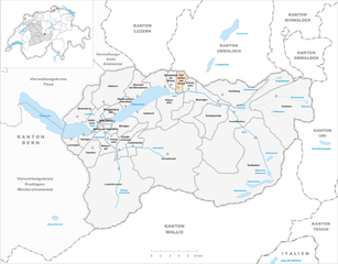
Бринцвилер (Brienzwiler, Brienzwiler)

 Hiking in Бринцвилер
Brienzwiler is a picturesque village located in the Bernese Oberland region of Switzerland, nestled between Lake Brienz and the towering peaks of the Alps. It's a fantastic destination for hiking enthusiasts, offering a variety of trails that cater to different skill levels, from leisurely walks to more challenging hikes. Here are some key points to consider when hiking in and around Brienzwiler:
Trail Recommendations:
-
Brienz to Giessbach Falls:
- A beautiful hike that leads you along the shores of Lake Brienz to the stunning Giessbach Falls. The area features well-maintained paths, and the falls themselves are a highlight, especially in the spring when the water flow is robust.
-
Trekking to Brienzer Rothorn:
- For those looking for a more challenging hike, consider making your way up to Brienzer Rothorn, one of the prominent peaks in the region. The views from the top are breathtaking, providing panoramic sights of the surrounding mountains and Lake Brienz.
-
Hike to Axalp:
- This trail takes you to the scenic village of Axalp, with beautiful views of the surrounding countryside. The path offers a moderate difficulty level and is well marked.
-
Lake Brienz Circular Trail:
- A more leisurely option is to hike part of the circular trail around Lake Brienz. This trail offers stunning vistas and the chance to take breaks at various viewpoints and beaches along the lake.
Best Time to Hike:
- The hiking season typically runs from late spring (May) to early autumn (October). Summer months provide the best weather conditions, but be prepared for variable alpine weather at higher elevations.
Preparation Tips:
- Weather Conditions: Always check the weather forecast before heading out, as conditions can change rapidly in the mountains.
- Gear: Wear appropriate hiking boots and carry layers, as temperatures can vary significantly from base to peak.
- Hydration: Ensure you have sufficient water and snacks to maintain your energy levels during your hike.
- Navigation: Familiarize yourself with local maps or consider downloading a hiking app for easier navigation along the trails.
Accessibility:
- Brienzwiler is easily accessible by public transportation, making it convenient for day trips from larger towns like Interlaken or Lucerne.
Safety:
- Always inform someone about your hiking plans and expected return time.
- Pay attention to trail markers and signs to stay on the correct path.
Overall, hiking in Brienzwiler is a rewarding experience with the stunning natural landscape and diverse trail offerings. Enjoy your time in this beautiful region!
- Страна:

- Почтовый код: 3856
- Телефонный код: 033
- Код автомобильного номера: BE
- Координаты: 46° 45' 5" N, 8° 6' 8" E


- GPS треки (wikiloc): [Ссылка]
- Высота над уровнем моря: 1045 м m
- Площадь: 17.6 кв.км
- Население: 494
- Веб сайт: http://www.brienzwiler.ch
- Википедия русская: wiki(ru)
- Википедия английская: wiki(en)
- Википедия национальная: wiki(de)
- Хранилище Wikidata: Wikidata: Q65211
- Катеория в википедии: [Ссылка]
- код Freebase: [/m/0c_pz2]
- код GeoNames: Альт: [7285334]
- код VIAF: Альт: [242765873]
- ID отношения в OpenStreetMap: [1682393]
- идентификатор HDS: [329]
- код швейцарского муниципалитета: [0574]
Граничит с регионами:


Гриндельвальд
Hiking in Гриндельвальд
Grindelwald is a stunning alpine village located in the Bernese Oberland region of Switzerland, known for its breathtaking landscapes, towering peaks, and diverse hiking trails. Here’s what you need to know about hiking in Grindelwald:...
- Страна:
- Почтовый код: 3818
- Телефонный код: 033
- Код автомобильного номера: BE
- Координаты: 46° 37' 9" N, 8° 3' 4" E
- GPS треки (wikiloc): [Ссылка]
- Высота над уровнем моря: 1142 м m
- Площадь: 171.28 кв.км
- Население: 4138
- Веб сайт: [Ссылка]


Майринген
Hiking in Майринген
Meiringen, a charming town in the Bernese Oberland region of Switzerland, is an excellent base for hikers looking to explore the stunning landscapes of the Alps. Here are some key points about hiking in Meiringen:...
- Страна:
- Почтовый код: 3860
- Телефонный код: 033
- Код автомобильного номера: BE
- Координаты: 46° 43' 42" N, 8° 11' 10" E
- GPS треки (wikiloc): [Ссылка]
- Высота над уровнем моря: 600 м m
- Площадь: 40.7 кв.км
- Население: 4690
- Веб сайт: [Ссылка]


Лунгерн
Hiking in Лунгерн
Lungern is a beautiful village situated in the Swiss canton of Obwalden, nestled between the spectacular mountains and alongside the pristine Lungern-Turren Lake. The area offers a variety of hiking opportunities that cater to different skill levels, making it an excellent destination for both casual walkers and seasoned hikers. Here are some highlights of hiking in Lungern:...
- Страна:
- Почтовый код: 6078
- Телефонный код: 041
- Код автомобильного номера: OW
- Координаты: 46° 47' 14" N, 8° 9' 35" E
- GPS треки (wikiloc): [Ссылка]
- Высота над уровнем моря: 716 м m
- Площадь: 46.47 кв.км
- Население: 2122
- Веб сайт: [Ссылка]

Хофштеттен-бай-Бриенц
Hiking in Хофштеттен-бай-Бриенц
Hofstetten bei Brienz is a picturesque village located in the Bernese Oberland region of Switzerland, renowned for its stunning natural landscapes and outdoor activities, including hiking. Here are some highlights and recommendations for hiking in and around Hofstetten bei Brienz:...
- Страна:
- Почтовый код: 3858
- Телефонный код: 033
- Код автомобильного номера: BE
- Координаты: 46° 45' 11" N, 8° 4' 34" E
- GPS треки (wikiloc): [Ссылка]
- Высота над уровнем моря: 646 м m
- Площадь: 8.7 кв.км
- Население: 531
- Веб сайт: [Ссылка]


Бринц
Hiking in Бринц
Brienz, located in the heart of Switzerland, is a beautiful destination for hiking enthusiasts. Nestled between Lake Brienz and the towering peaks of the Alps, this charming village offers a variety of hiking trails suitable for all skill levels....
- Страна:
- Почтовый код: 3855
- Телефонный код: 033
- Код автомобильного номера: BE
- Координаты: 46° 44' 59" N, 8° 2' 0" E
- GPS треки (wikiloc): [Ссылка]
- Высота над уровнем моря: 566 м m
- Площадь: 48.0 кв.км
- Население: 3120
- Веб сайт: [Ссылка]