
Гриндельвальд (Grindelwald, Grindelwald)

 Hiking in Гриндельвальд
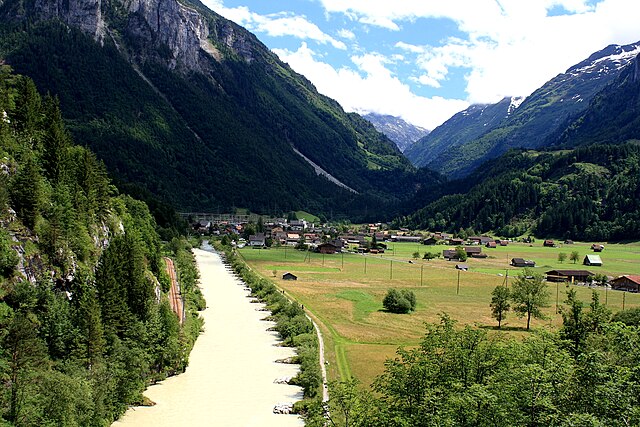
Grindelwald is a stunning alpine village located in the Bernese Oberland region of Switzerland, known for its breathtaking landscapes, towering peaks, and diverse hiking trails. Here’s what you need to know about hiking in Grindelwald:
Trails and Routes
-
First to Bachalpsee: This is a popular and relatively easy hike that takes you to Bachalpsee, a beautiful mountain lake. The trail starts from the First cable car station and offers fantastic views of the surrounding mountains, including the famous Eiger.
-
Eiger Trail: This trail runs along the foot of the Eiger Mountain and provides close-up views of the north face. It's moderate in difficulty and allows hikers to learn about the area's history and geology through informative signs along the route.
-
Männlichen to Kleine Scheidegg: A scenic hike that offers panoramic views of the Eiger, Mönch, and Jungfrau. The trail is well-marked and varies in difficulty, making it suitable for a wide range of hikers.
-
Grosse Scheidegg: This trail takes you from Grosse Scheidegg back to Grindelwald. It's a longer hike with stunning views and is often less crowded than other popular trails.
-
Hike to Gletscher: For those seeking a more challenging experience, consider hiking towards the glacier at the top of the valley. This hike can vary in difficulty, and conditions may change based on the season, so check local guides for current trail conditions.
Tips for Hiking in Grindelwald
- Check the Weather: Mountain weather can change rapidly. Always check the forecast and be prepared for varying conditions.
- Dress in Layers: Wear breathable and moisture-wicking clothing, as temperatures can fluctuate significantly throughout the day.
- Start Early: To avoid crowds and enjoy the tranquility of the mountains, start your hikes early in the morning.
- Stay Hydrated and Pack Snacks: Bring plenty of water and energy-boosting snacks, especially for longer hikes.
- Respect Nature: Follow trail etiquette, stay on marked paths, and carry out any trash you bring along.
- Consider Cable Cars: You can use cable cars to access higher trails, making it easier to enjoy alpine scenery without a strenuous ascent.
Best Time to Visit
The hiking season in Grindelwald typically runs from late Spring (May) to early Autumn (October). However, the best times for hiking are usually late June to September when most trails are fully accessible and the weather is more stable.
Grindelwald offers a wealth of natural beauty and a variety of hiking opportunities for all levels of experience, making it a fantastic destination for anyone looking to explore the Swiss Alps!
- Страна:

- Почтовый код: 3818
- Телефонный код: 033
- Код автомобильного номера: BE
- Координаты: 46° 37' 9" N, 8° 3' 4" E


- GPS треки (wikiloc): [Ссылка]
- Высота над уровнем моря: 1142 м m
- Площадь: 171.28 кв.км
- Население: 4138
- Веб сайт: http://www.grindelwald.com
- Википедия русская: wiki(ru)
- Википедия английская: wiki(en)
- Википедия национальная: wiki(de)
- Хранилище Wikidata: Wikidata: Q64004
- Катеория в википедии: [Ссылка]
- код Freebase: [/m/02wlp7]
- код GeoNames: Альт: [7285984]
- код BNF: [12128210t]
- код VIAF: Альт: [248094491]
- ID отношения в OpenStreetMap: [1682457]
- код GND: Альт: [4086804-7]
- место в MusicBrainz: [d1045bb6-dac5-4481-baa1-4bf0a10a57aa]
- код в энциклопедии «Британника онлайн»: [place/Grindelwald]
- идентификатор HDS: [331]
- код швейцарского муниципалитета: [0576]
- идентификатор NE.se: [grindelwald]
Граничит с регионами:


Лаутербруннен
Hiking in Лаутербруннен
Lauterbrunnen is a stunning valley located in the Swiss Alps, known for its dramatic cliffs and impressive waterfalls. It serves as a gateway to the Jungfrau region and offers a variety of hiking opportunities, suitable for different skill levels. Here are some key highlights and tips for hiking in Lauterbrunnen:...
- Страна:
- Почтовый код: 3822
- Телефонный код: 033
- Код автомобильного номера: BE
- Координаты: 46° 33' 6" N, 7° 53' 37" E
- GPS треки (wikiloc): [Ссылка]
- Высота над уровнем моря: 1407 м m
- Площадь: 164.4 кв.км
- Население: 2732
- Веб сайт: [Ссылка]


Майринген
Hiking in Майринген
Meiringen, a charming town in the Bernese Oberland region of Switzerland, is an excellent base for hikers looking to explore the stunning landscapes of the Alps. Here are some key points about hiking in Meiringen:...
- Страна:
- Почтовый код: 3860
- Телефонный код: 033
- Код автомобильного номера: BE
- Координаты: 46° 43' 42" N, 8° 11' 10" E
- GPS треки (wikiloc): [Ссылка]
- Высота над уровнем моря: 600 м m
- Площадь: 40.7 кв.км
- Население: 4690
- Веб сайт: [Ссылка]


Изельтвальд
Hiking in Изельтвальд
Iseltwald, a charming village located along the shores of Lake Brienz in Switzerland, offers a stunning backdrop for hiking enthusiasts. The area is known for its breathtaking landscapes, including pristine lake views and majestic alpine scenery. Here are some key points to consider when hiking in Iseltwald:...
- Страна:
- Почтовый код: 3807
- Телефонный код: 033
- Код автомобильного номера: BE
- Координаты: 46° 42' 35" N, 7° 57' 49" E
- GPS треки (wikiloc): [Ссылка]
- Высота над уровнем моря: 1986 м m
- Площадь: 21.9 кв.км
- Население: 441
- Веб сайт: [Ссылка]


Бринцвилер
Hiking in Бринцвилер
Brienzwiler is a picturesque village located in the Bernese Oberland region of Switzerland, nestled between Lake Brienz and the towering peaks of the Alps. It's a fantastic destination for hiking enthusiasts, offering a variety of trails that cater to different skill levels, from leisurely walks to more challenging hikes. Here are some key points to consider when hiking in and around Brienzwiler:...
- Страна:
- Почтовый код: 3856
- Телефонный код: 033
- Код автомобильного номера: BE
- Координаты: 46° 45' 5" N, 8° 6' 8" E
- GPS треки (wikiloc): [Ссылка]
- Высота над уровнем моря: 1045 м m
- Площадь: 17.6 кв.км
- Население: 494
- Веб сайт: [Ссылка]


Бринц
Hiking in Бринц
Brienz, located in the heart of Switzerland, is a beautiful destination for hiking enthusiasts. Nestled between Lake Brienz and the towering peaks of the Alps, this charming village offers a variety of hiking trails suitable for all skill levels....
- Страна:
- Почтовый код: 3855
- Телефонный код: 033
- Код автомобильного номера: BE
- Координаты: 46° 44' 59" N, 8° 2' 0" E
- GPS треки (wikiloc): [Ссылка]
- Высота над уровнем моря: 566 м m
- Площадь: 48.0 кв.км
- Население: 3120
- Веб сайт: [Ссылка]


Шаттенхальб
Hiking in Шаттенхальб
Schattenhalb is a picturesque area located in the Bernese Oberland of Switzerland, renowned for its stunning landscapes and excellent hiking opportunities. Here are some key points about hiking in this region:...
- Страна:
- Почтовый код: 3860
- Телефонный код: 033
- Код автомобильного номера: BE
- Координаты: 46° 41' 39" N, 8° 10' 12" E
- GPS треки (wikiloc): [Ссылка]
- Высота над уровнем моря: 1300 м m
- Площадь: 31.5 кв.км
- Население: 560
- Веб сайт: [Ссылка]


Люченталь
Hiking in Люченталь
Lütschental is a picturesque valley located in the Bernese Oberland region of Switzerland, known for its stunning alpine scenery and diverse hiking opportunities. Here are some highlights and tips for hiking in Lütschental:...
- Страна:
- Почтовый код: 3816
- Телефонный код: 033
- Код автомобильного номера: BE
- Координаты: 46° 38' 38" N, 7° 57' 8" E
- GPS треки (wikiloc): [Ссылка]
- Высота над уровнем моря: 1243 м m
- Площадь: 12.4 кв.км
- Население: 219
- Веб сайт: [Ссылка]

Иннерткирхен
Hiking in Иннерткирхен
Innertkirchen, located in the Bernese Oberland region of Switzerland, is a fantastic destination for hiking enthusiasts. Nestled between the majestic mountains of the Alps, it offers breathtaking landscapes and a variety of trails suitable for different skill levels. Here’s what you can expect when hiking in and around Innertkirchen:...
- Страна:
- Почтовый код: 3862
- Телефонный код: 033
- Код автомобильного номера: BE
- Координаты: 46° 41' 59" N, 8° 14' 0" E
- GPS треки (wikiloc): [Ссылка]
- Высота над уровнем моря: 625 м m
- Площадь: 120.0 кв.км
- Население: 1076
- Веб сайт: [Ссылка]


Гуттаннен
Hiking in Гуттаннен
Guttannen, located in the Bernese Oberland region of Switzerland, is a small village surrounded by stunning alpine scenery. It's an excellent base for hiking enthusiasts looking to explore the natural beauty of the Swiss Alps. Here’s an overview of what you can expect when hiking in and around Guttannen:...
- Страна:
- Почтовый код: 3864
- Телефонный код: 033
- Код автомобильного номера: BE
- Координаты: 46° 38' 59" N, 8° 17' 0" E
- GPS треки (wikiloc): [Ссылка]
- Высота над уровнем моря: 1057 м m
- Площадь: 200.7 кв.км
- Население: 266
- Веб сайт: [Ссылка]


Fieschertal
Hiking in Fieschertal
Fieschertal, located in the Swiss Alps in the municipality of Fiesch, is a picturesque destination for hiking enthusiasts. The region is renowned for its stunning landscapes, lush valleys, and breathtaking mountain views, making it an excellent choice for hikers of all levels....
- Страна:
- Почтовый код: 3984
- Телефонный код: 027
- Код автомобильного номера: VS
- Координаты: 46° 30' 0" N, 8° 8' 0" E
- GPS треки (wikiloc): [Ссылка]
- Высота над уровнем моря: 1108 м m
- Площадь: 172.96 кв.км
- Население: 334
- Веб сайт: [Ссылка]