
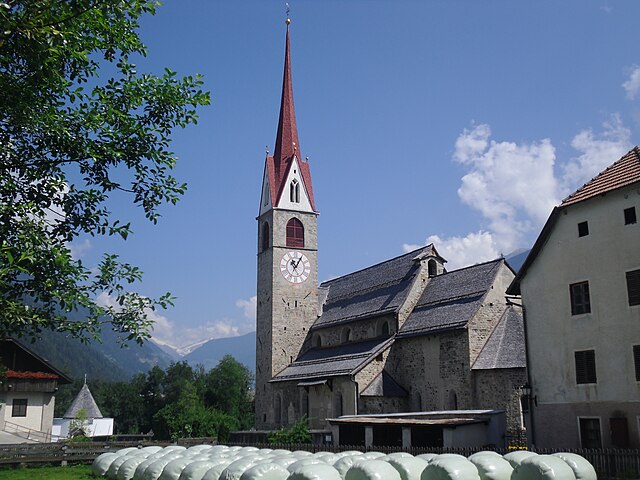
Брунико (Bruneck, Brunico)
.svg)
- коммуна Италии
 Hiking in Брунико
Bruneck (Brunico in Italian) is a charming town located in South Tyrol, Northern Italy, surrounded by the stunning Dolomites mountain range. It serves as a fantastic base for hiking enthusiasts, offering a variety of trails suitable for all skill levels. Here are some key points to consider when planning your hiking adventure in and around Bruneck:
Hiking Trails
-
Speikboden: This area offers a network of well-marked trails, ranging from easy walks to challenging hikes. The views of the surrounding mountains and valleys are breathtaking, especially during the summer months.
-
Plan de Corones (Kronplatz): This popular ski resort transforms into a hiking paradise in the warmer months. There are numerous trails of varying difficulty, and the area is known for its well-maintained infrastructure, including cable cars that can help you reach higher altitudes with ease.
-
Ahrntal Valley: A bit further from Bruneck, this valley features some spectacular hiking routes. Trails here can lead you to stunning glacial lakes, waterfalls, and panoramic viewpoints.
-
The Rein in Vals (Rio di Pusteria): This scenic area offers relatively easy hikes that are suitable for families, making it a great option if you're hiking with kids.
Difficulty Levels
- Easy Trails: Suitable for beginners and families, often involving gentle slopes and well-marked paths.
- Moderate Trails: These may include some elevation gain and more rugged terrain, perfect for those looking for a bit of a workout.
- Difficult Trails: Recommended for experienced hikers, these routes can be steep and may require scrambling.
Best Times to Hike
- Summer (June to September): The best time for hiking in Bruneck, with warm temperatures and fully accessible trails.
- Fall (October): Offers stunning autumn colors and fewer crowds. However, be mindful of shorter daylight hours and variable weather conditions.
Preparation Tips
- Gear: Good hiking boots, weather-appropriate clothing, and a trusty backpack with water and snacks are essential. Consider trekking poles for more challenging terrain.
- Maps & Guides: It's advisable to carry a trail map or use hiking apps to help with navigation. Local tourist offices often provide helpful information on route conditions.
Local Attractions
After a day of hiking, explore Bruneck's charming streets, visit the medieval Bruneck Castle, or enjoy local cuisine in one of the town's restaurants. The blend of culture and outdoor adventure makes Bruneck a delightful destination for hiking enthusiasts.
Always remember to check the weather and trail conditions before setting off, and inform someone about your plans. Happy hiking!
- Страна:

- Почтовый код: 39031
- Телефонный код: 0474
- Код автомобильного номера: BZ
- Координаты: 46° 47' 58" N, 11° 56' 3" E


- GPS треки (wikiloc): [Ссылка]
- Высота над уровнем моря: 838 м m
- Площадь: 45.27 кв.км
- Население: 16356
- Веб сайт: http://www.comune.brunico.bz.it/
- Википедия русская: wiki(ru)
- Википедия английская: wiki(en)
- Википедия национальная: wiki(it)
- Хранилище Wikidata: Wikidata: Q256765
- Галерея изображений в википедии: [Ссылка]
- Катеория в википедии: [Ссылка]
- код Freebase: [/m/0bk4m6]
- код GeoNames: Альт: [6535968]
- код BNF: [14420219s]
- код VIAF: Альт: [125617018]
- ID отношения в OpenStreetMap: [47317]
- код GND: Альт: [4008477-2]
- идентификатор местоположения ArchINFORM: [12114]
- код LCNAF: Альт: [n90622534]
- место в MusicBrainz: [04616291-d437-4c4b-a166-174554b04f16]
- код темы Quora: [Bruneck]
- UN/LOCODE: [ITZDS]
- код ISTAT: 021013
- кадастровый код Италии: B220
Граничит с регионами:


Разун-Антерсельва
- коммуна в Италии
Hiking in Разун-Антерсельва
Rasen-Antholz (Rasen-Antholz in German, or Rasun-Anterselva in Italian) is a picturesque valley located in the South Tyrol region of northern Italy, surrounded by the stunning Dolomites. This area is particularly popular for hiking due to its breathtaking landscapes, diverse trails, and natural beauty....
- Страна:
- Почтовый код: 39030
- Телефонный код: 0474
- Код автомобильного номера: BZ
- Координаты: 46° 51' 0" N, 12° 6' 0" E
- GPS треки (wikiloc): [Ссылка]
- Высота над уровнем моря: 1030 м m
- Площадь: 121.57 кв.км
- Население: 2907
- Веб сайт: [Ссылка]
Фальцес
- коммуна Италии
Hiking in Фальцес
Pfalzen, also known as Falzes, is a charming village located in South Tyrol, Italy, nestled in the stunning Dolomites region. It offers a variety of hiking opportunities for all levels of hikers, with beautiful landscapes, scenic views, and a rich natural environment....
- Страна:
- Почтовый код: 39030
- Телефонный код: 0474
- Код автомобильного номера: BZ
- Координаты: 46° 48' 49" N, 11° 52' 59" E
- GPS треки (wikiloc): [Ссылка]
- Высота над уровнем моря: 1022 м m
- Площадь: 33.13 кв.км
- Население: 2783
- Веб сайт: [Ссылка]

Гайс
- коммуна Италии
Hiking in Гайс
Gais, a picturesque village in South Tyrol, Italy, is an excellent destination for hiking enthusiasts. Nestled in the shadow of the stunning Dolomites, the area offers breathtaking landscapes, diverse trails, and a rich cultural heritage. Here’s an overview of what you can expect while hiking in and around Gais:...
- Страна:
- Почтовый код: 39030
- Телефонный код: 0474
- Код автомобильного номера: BZ
- Координаты: 46° 50' 0" N, 11° 57' 0" E
- GPS треки (wikiloc): [Ссылка]
- Высота над уровнем моря: 841 м m
- Площадь: 60.62 кв.км
- Население: 3279
- Веб сайт: [Ссылка]


Мареббе
- коммуна Италии
Hiking in Мареббе
Mareo is a charming area in the Asturias region of northern Spain, known for its breathtaking natural landscapes, rich biodiversity, and traditional villages. Hiking in Mareo can be a rewarding experience, offering various trails that cater to hikers of different skill levels. Here are a few key points to consider if you plan on hiking in this area:...
- Страна:
- Почтовый код: 39030
- Телефонный код: 0474
- Код автомобильного номера: BZ
- Координаты: 46° 43' 8" N, 11° 55' 1" E
- GPS треки (wikiloc): [Ссылка]
- Высота над уровнем моря: 1186 м m
- Площадь: 160.32 кв.км
- Население: 3037
- Веб сайт: [Ссылка]


Перка
- коммуна в Италии
Hiking in Перка
Percha, known for its beautiful landscapes and outdoor recreational opportunities, offers a variety of hiking experiences for outdoor enthusiasts. While specific trails and details may vary, here are some general points to consider if you're planning to hike in this area:...
- Страна:
- Почтовый код: 39030
- Телефонный код: 0474
- Код автомобильного номера: BZ
- Координаты: 46° 47' 36" N, 11° 59' 0" E
- GPS треки (wikiloc): [Ссылка]
- Высота над уровнем моря: 972 м m
- Площадь: 30.36 кв.км
- Население: 1550
- Веб сайт: [Ссылка]


Вальдаора
- коммуна в Италии
Hiking in Вальдаора
Olang, also known as Valdaora, is a picturesque village located in the South Tyrol region of northern Italy, nestled in the Dolomites. This area is renowned for its stunning landscapes, rich culture, and diverse hiking opportunities. Here's what you need to know about hiking in Olang:...
- Страна:
- Почтовый код: 39030
- Телефонный код: 0474
- Код автомобильного номера: BZ
- Координаты: 46° 45' 37" N, 12° 1' 46" E
- GPS треки (wikiloc): [Ссылка]
- Высота над уровнем моря: 1048 м m
- Площадь: 49.08 кв.км
- Население: 3174
- Веб сайт: [Ссылка]


Сан-Лоренцо-ди-Себато
- коммуна в Италии
Hiking in Сан-Лоренцо-ди-Себато
St. Lorenzen, located in the picturesque region of South Tyrol in northern Italy, offers a variety of hiking opportunities suitable for all skill levels. The area is known for its stunning natural landscapes, including mountains, forests, and charming meadows, making it an excellent destination for outdoor enthusiasts....
- Страна:
- Почтовый код: 39030
- Телефонный код: 0474
- Код автомобильного номера: BZ
- Координаты: 46° 47' 7" N, 11° 54' 29" E
- GPS треки (wikiloc): [Ссылка]
- Высота над уровнем моря: 810 м m
- Площадь: 51.46 кв.км
- Население: 3889
- Веб сайт: [Ссылка]