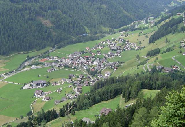
Разун-Антерсельва (Rasen-Antholz, Rasun-Anterselva)
.svg)
- коммуна в Италии
 Hiking in Разун-Антерсельва
Rasen-Antholz (Rasen-Antholz in German, or Rasun-Anterselva in Italian) is a picturesque valley located in the South Tyrol region of northern Italy, surrounded by the stunning Dolomites. This area is particularly popular for hiking due to its breathtaking landscapes, diverse trails, and natural beauty.
Hiking Highlights in Rasen-Antholz
-
Diverse Trails: Rasen-Antholz offers a variety of hiking trails suited for all skill levels. You can find easy, family-friendly paths as well as challenging routes for experienced hikers.
-
Scenic Views: The area is known for its stunning mountain vistas, lush forests, and beautiful lakes. Popular sights include the picturesque Antholzer See (Antholz Lake), which is surrounded by hiking trails and perfect for a relaxing stop.
-
Wildlife Watching: The region boasts rich flora and fauna. Keep an eye out for different species of birds, deer, and other wildlife as you explore the trails.
-
Cultural Experiences: While hiking, you can also discover quaint villages, local churches, and traditional South Tyrolean architecture. The culture and hospitality of the local people enhance the hiking experience.
-
Guided Tours: If you prefer, you can join guided hikes offered by local tour operators. These guides can provide valuable insights into the local environment, flora, and fauna.
Popular Hiking Routes
-
Antholzer See Loop: This is a relatively easy loop around Antholz Lake, perfect for families and those looking for a leisurely hike.
-
Trail to the Burkhard Ruins: A moderate hike that offers stunning views of the valley and leads to the remnants of a historic castle.
-
Piz de Cortina: A more challenging hike that takes you up to impressive altitudes with rewarding panoramic views of the surrounding Dolomites.
Hiking Tips
-
Season: The best time to hike in Rasen-Antholz is during late spring to early fall (May to September) when the weather is milder. However, be prepared for changing weather conditions, especially in mountainous areas.
-
Gear: Proper hiking boots, weather-appropriate clothing, and sufficient water and snacks are essential. A map or GPS device can help navigate the trails.
-
Local Rules: Respect the local flora and fauna and follow marked trails. Inform someone about your hiking plans if you're going solo.
Conclusion
Hiking in Rasen-Antholz is an unforgettable experience, offering a blend of natural beauty, outdoor adventure, and cultural richness. Whether you are a seasoned hiker or a beginner, the area has something to offer everyone. Just remember to prepare accordingly and enjoy the stunning landscapes!
- Страна:

- Почтовый код: 39030
- Телефонный код: 0474
- Код автомобильного номера: BZ
- Координаты: 46° 51' 0" N, 12° 6' 0" E


- GPS треки (wikiloc): [Ссылка]
- Высота над уровнем моря: 1030 м m
- Площадь: 121.57 кв.км
- Население: 2907
- Веб сайт: http://www.comune.rasunanterselva.bz.it/
- Википедия русская: wiki(ru)
- Википедия английская: wiki(en)
- Википедия национальная: wiki(it)
- Хранилище Wikidata: Wikidata: Q193711
- Галерея изображений в википедии: [Ссылка]
- Катеория в википедии: [Ссылка]
- код Freebase: [/m/0g9j4w]
- код GeoNames: Альт: [6534785]
- код VIAF: Альт: [240535939]
- ID отношения в OpenStreetMap: [47320]
- код GND: Альт: [4552582-1]
- место в MusicBrainz: [44ba3f3a-9edb-48c5-b7c5-66c86e5a7b92]
- UN/LOCODE: [ITRAU]
- код ISTAT: 021071
- кадастровый код Италии: H189
Граничит с регионами:


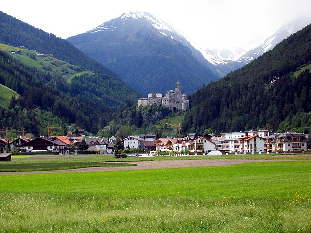
Брунико
- коммуна Италии
Hiking in Брунико
Bruneck (Brunico in Italian) is a charming town located in South Tyrol, Northern Italy, surrounded by the stunning Dolomites mountain range. It serves as a fantastic base for hiking enthusiasts, offering a variety of trails suitable for all skill levels. Here are some key points to consider when planning your hiking adventure in and around Bruneck:...
- Страна:
- Почтовый код: 39031
- Телефонный код: 0474
- Код автомобильного номера: BZ
- Координаты: 46° 47' 58" N, 11° 56' 3" E
- GPS треки (wikiloc): [Ссылка]
- Высота над уровнем моря: 838 м m
- Площадь: 45.27 кв.км
- Население: 16356
- Веб сайт: [Ссылка]
Санкт-Якоб-ин-Деферегген
Hiking in Санкт-Якоб-ин-Деферегген
St. Jakob in Defereggen, located in the Austrian Alps in the East Tyrol region, is a fantastic destination for hiking enthusiasts. The area is known for its stunning natural landscapes, diverse flora and fauna, and breathtaking mountain views. Here are some key highlights about hiking in this beautiful area:...
- Страна:

- Почтовый код: 9963
- Телефонный код: 04873
- Код автомобильного номера: LZ
- Координаты: 46° 56' 30" N, 12° 14' 48" E
- GPS треки (wikiloc): [Ссылка]
- Высота над уровнем моря: 2570 м m
- Площадь: 186 кв.км
- Население: 848
- Веб сайт: [Ссылка]

Кампо-Турес
- коммуна Италии
Hiking in Кампо-Турес
Sand in Taufers, or Campo Tures as it is known in Italian, is a picturesque village located in the Ahrntal Valley in South Tyrol, Italy. It's renowned for its stunning natural scenery, rich cultural heritage, and a variety of outdoor activities, particularly hiking. Here are some key points about hiking in this beautiful region:...
- Страна:
- Почтовый код: 39032
- Телефонный код: 0474
- Код автомобильного номера: BZ
- Координаты: 46° 54' 30" N, 11° 57' 37" E
- GPS треки (wikiloc): [Ссылка]
- Высота над уровнем моря: 864 м m
- Площадь: 163.98 кв.км
- Население: 5430
- Веб сайт: [Ссылка]


Перка
- коммуна в Италии
Hiking in Перка
Percha, known for its beautiful landscapes and outdoor recreational opportunities, offers a variety of hiking experiences for outdoor enthusiasts. While specific trails and details may vary, here are some general points to consider if you're planning to hike in this area:...
- Страна:
- Почтовый код: 39030
- Телефонный код: 0474
- Код автомобильного номера: BZ
- Координаты: 46° 47' 36" N, 11° 59' 0" E
- GPS треки (wikiloc): [Ссылка]
- Высота над уровнем моря: 972 м m
- Площадь: 30.36 кв.км
- Население: 1550
- Веб сайт: [Ссылка]


Монгуэльфо-Тезидо
- коммуна Италии
Hiking in Монгуэльфо-Тезидо
Welsberg-Taisten is a beautiful hiking destination located in the South Tyrol region of northern Italy. Nestled in the Dolomites, it offers a wide range of hiking trails suitable for various skill levels, from easy strolls to challenging ascents. Here are some key points about hiking in this area:...
- Страна:
- Почтовый код: 39035
- Телефонный код: 0474
- Код автомобильного номера: BZ
- Координаты: 46° 45' 28" N, 12° 6' 20" E
- GPS треки (wikiloc): [Ссылка]
- Высота над уровнем моря: 1087 м m
- Площадь: 46.44 кв.км
- Население: 2867
- Веб сайт: [Ссылка]


Вальдаора
- коммуна в Италии
Hiking in Вальдаора
Olang, also known as Valdaora, is a picturesque village located in the South Tyrol region of northern Italy, nestled in the Dolomites. This area is renowned for its stunning landscapes, rich culture, and diverse hiking opportunities. Here's what you need to know about hiking in Olang:...
- Страна:
- Почтовый код: 39030
- Телефонный код: 0474
- Код автомобильного номера: BZ
- Координаты: 46° 45' 37" N, 12° 1' 46" E
- GPS треки (wikiloc): [Ссылка]
- Высота над уровнем моря: 1048 м m
- Площадь: 49.08 кв.км
- Население: 3174
- Веб сайт: [Ссылка]


Валле-ди-Казиес
- коммуна в Италии
Hiking in Валле-ди-Казиес
Gsies, located in the South Tyrol region of northern Italy, is a picturesque valley surrounded by the stunning Dolomites and offers a variety of hiking opportunities. Here are some highlights and tips for hiking in Gsies:...
- Страна:
- Почтовый код: 39035
- Телефонный код: 0474
- Код автомобильного номера: BZ
- Координаты: 46° 46' 6" N, 12° 10' 46" E
- GPS треки (wikiloc): [Ссылка]
- Высота над уровнем моря: 1305 м m
- Площадь: 110.14 кв.км
- Население: 2329
- Веб сайт: [Ссылка]