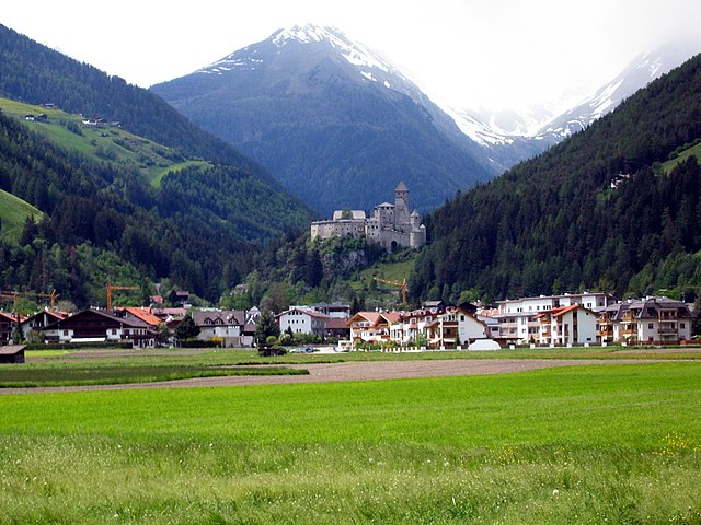
Гайс (Gais, South Tyrol, Gais)
.svg)
- коммуна Италии
 Hiking in Гайс
Gais, a picturesque village in South Tyrol, Italy, is an excellent destination for hiking enthusiasts. Nestled in the shadow of the stunning Dolomites, the area offers breathtaking landscapes, diverse trails, and a rich cultural heritage. Here’s an overview of what you can expect while hiking in and around Gais:
Hiking Trails
-
Varied Difficulty Levels: Gais offers a wide range of hiking trails suitable for all levels, from easy walks for beginners to challenging treks for experienced hikers.
-
Scenic Routes: The trails often showcase stunning panoramas of the surrounding mountains, valleys, and forests. Popular routes include the hikes through the Riva di Tures, which offers waterfalls and lush nature.
-
Sella and Puster Valley: This area features trails that provide excellent opportunities to explore the natural beauty of South Tyrol's landscape.
-
Explore Ancient Sites: Some trails might take you past historical or cultural landmarks, giving insight into the region's history.
Equipment and Preparation
- Footwear: Sturdy hiking boots are essential for comfort and safety, especially on uneven terrain.
- Weather Awareness: Be sure to check the weather forecasts before heading out, as conditions can change rapidly in mountain areas.
- Hydration and Snacks: Carry sufficient water and energy-rich snacks to keep your energy levels up during the hikes.
Wildlife and Flora
The region around Gais is home to unique flora and fauna. You may encounter various plant species as well as wildlife such as deer, marmots, and various birds, especially in protected areas.
Cultural Aspects
- Local Cuisine: After a day of hiking, you can enjoy traditional South Tyrolean cuisine in the local restaurants, featuring hearty dishes that reflect the area's cultural blend of Italian and Austrian influences.
- Festivals and Events: Depending on the time of year, you may also stumble upon local festivals or events celebrating the rich heritage of the area.
Season Considerations
- Spring/Summer: The best time for hiking, with clear trails and blooming wildflowers. Ensure to check for trail openings as some areas may still have snow in early spring.
- Autumn: Stunning fall colors make for a beautiful hiking experience, though days can be cooler and shorter.
- Winter: While not typical for traditional hiking, winter sports such as snowshoeing or winter hiking may be available depending on snow conditions.
Safety and Preservation
- Always stick to marked trails to preserve the natural environment and ensure your safety.
- Make sure to carry out any trash you bring with you and follow the Leave No Trace principles.
Conclusion
Hiking in Gais, South Tyrol offers a fantastic way to explore the area's natural beauty and cultural richness. With its varied trails and stunning scenery, you’ll find plenty of opportunities for adventure and relaxation in this beautiful corner of Italy. Always remember to prepare adequately and enjoy the experience to the fullest!
- Страна:

- Почтовый код: 39030
- Телефонный код: 0474
- Код автомобильного номера: BZ
- Координаты: 46° 50' 0" N, 11° 57' 0" E


- GPS треки (wikiloc): [Ссылка]
- Высота над уровнем моря: 841 м m
- Площадь: 60.62 кв.км
- Население: 3279
- Веб сайт: http://www.gemeinde.gais.bz.it
- Википедия русская: wiki(ru)
- Википедия английская: wiki(en)
- Википедия национальная: wiki(it)
- Хранилище Wikidata: Wikidata: Q419157
- Галерея изображений в википедии: [Ссылка]
- Катеория в википедии: [Ссылка]
- код Freebase: [/m/0g9gps]
- код GeoNames: Альт: [6535898]
- код VIAF: Альт: [148771702]
- ID отношения в OpenStreetMap: [47331]
- код GND: Альт: [4528047-2]
- место в MusicBrainz: [a50f86fa-94aa-4397-8d1e-60a6ed46085c]
- WOEID: [715924]
- UN/LOCODE: [ITGIS]
- код ISTAT: 021034
- кадастровый код Италии: D860
Граничит с регионами:


Брунико
- коммуна Италии
Hiking in Брунико
Bruneck (Brunico in Italian) is a charming town located in South Tyrol, Northern Italy, surrounded by the stunning Dolomites mountain range. It serves as a fantastic base for hiking enthusiasts, offering a variety of trails suitable for all skill levels. Here are some key points to consider when planning your hiking adventure in and around Bruneck:...
- Страна:
- Почтовый код: 39031
- Телефонный код: 0474
- Код автомобильного номера: BZ
- Координаты: 46° 47' 58" N, 11° 56' 3" E
- GPS треки (wikiloc): [Ссылка]
- Высота над уровнем моря: 838 м m
- Площадь: 45.27 кв.км
- Население: 16356
- Веб сайт: [Ссылка]

Кампо-Турес
- коммуна Италии
Hiking in Кампо-Турес
Sand in Taufers, or Campo Tures as it is known in Italian, is a picturesque village located in the Ahrntal Valley in South Tyrol, Italy. It's renowned for its stunning natural scenery, rich cultural heritage, and a variety of outdoor activities, particularly hiking. Here are some key points about hiking in this beautiful region:...
- Страна:
- Почтовый код: 39032
- Телефонный код: 0474
- Код автомобильного номера: BZ
- Координаты: 46° 54' 30" N, 11° 57' 37" E
- GPS треки (wikiloc): [Ссылка]
- Высота над уровнем моря: 864 м m
- Площадь: 163.98 кв.км
- Население: 5430
- Веб сайт: [Ссылка]
Фальцес
- коммуна Италии
Hiking in Фальцес
Pfalzen, also known as Falzes, is a charming village located in South Tyrol, Italy, nestled in the stunning Dolomites region. It offers a variety of hiking opportunities for all levels of hikers, with beautiful landscapes, scenic views, and a rich natural environment....
- Страна:
- Почтовый код: 39030
- Телефонный код: 0474
- Код автомобильного номера: BZ
- Координаты: 46° 48' 49" N, 11° 52' 59" E
- GPS треки (wikiloc): [Ссылка]
- Высота над уровнем моря: 1022 м m
- Площадь: 33.13 кв.км
- Население: 2783
- Веб сайт: [Ссылка]


Перка
- коммуна в Италии
Hiking in Перка
Percha, known for its beautiful landscapes and outdoor recreational opportunities, offers a variety of hiking experiences for outdoor enthusiasts. While specific trails and details may vary, here are some general points to consider if you're planning to hike in this area:...
- Страна:
- Почтовый код: 39030
- Телефонный код: 0474
- Код автомобильного номера: BZ
- Координаты: 46° 47' 36" N, 11° 59' 0" E
- GPS треки (wikiloc): [Ссылка]
- Высота над уровнем моря: 972 м m
- Площадь: 30.36 кв.км
- Население: 1550
- Веб сайт: [Ссылка]

Сельва-дей-Молини
- коммуна в Италии
Hiking in Сельва-дей-Молини
Mühlwald, located in South Tyrol, Italy, offers beautiful hiking opportunities set against a stunning backdrop of the Eastern Alps. The region is known for its lush landscapes, diverse flora and fauna, and well-marked trails that cater to various skill levels, from easy walks to challenging mountain hikes. Here are some highlights of hiking in Mühlwald:...
- Страна:
- Почтовый код: 39030
- Телефонный код: 0474
- Код автомобильного номера: BZ
- Координаты: 46° 53' 25" N, 11° 51' 30" E
- GPS треки (wikiloc): [Ссылка]
- Высота над уровнем моря: 1229 м m
- Площадь: 104.79 кв.км
- Население: 1437
- Веб сайт: [Ссылка]