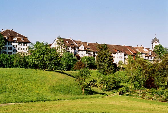
Бубикон (Bubikon, Bubikon)

- коммуна в Швейцарии
 Hiking in Бубикон
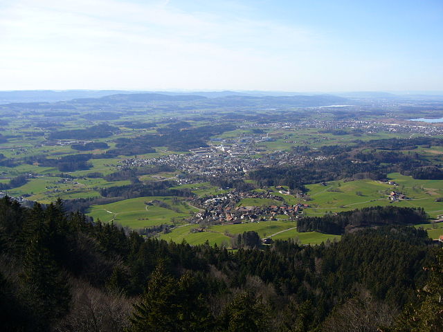
Bubikon, located in the Zurich region of Switzerland, offers picturesque hiking opportunities with breathtaking views of the surrounding landscape. It is part of the Zurich Oberland and is situated near the eastern shores of Lake Zurich. Here are some highlights and tips for hiking in Bubikon:
Trails and Routes:
-
Local Trails: Bubikon has several well-marked local hiking trails that wind through lush forests, meadows, and farmland. The trails vary in difficulty, making it accessible for both beginners and experienced hikers.
-
Goldingen Trail: This popular trail connects Bubikon to the nearby village of Goldingen. It offers scenic views and is relatively straightforward, perfect for a half-day hike.
-
Lake Zurich Loop: Though a bit further from Bubikon, the trails that circle Lake Zurich are stunning, providing a mix of nature and quaint lakeside towns.
-
Rabbit Trail (Hasenweg): A family-friendly trail ideal for children, featuring nature-related activities along the way.
Tips for Hiking in Bubikon:
-
Best Time to Hike: The best seasons for hiking in Bubikon are spring through fall. Spring offers beautiful wildflowers, while autumn provides stunning foliage.
-
Weather Considerations: Always check the weather forecast before your hike. Trails can be muddy after rain, so sturdy shoes are recommended.
-
Local Facilities: Bubikon has amenities including cafes and restaurants where you can rest and enjoy local cuisine after your hike.
-
Public Transport Access: The area is accessible via public transport, including trains and buses, making it easy to reach starting points for various trails without needing a car.
Safety Considerations:
- Carry sufficient water and snacks, especially on longer hikes.
- Be aware of your surroundings and follow trail markers to stay on designated paths.
- Inform someone of your hiking plans, particularly if venturing on less traveled routes.
Conclusion:
Hiking in Bubikon provides an excellent opportunity to experience Switzerland's natural beauty, complete with cultural touches and charming scenery. Whether you opt for a short walk or a more challenging trek, you'll be rewarded with the serene landscapes of the Zurich Oberland. Happy hiking!
- Страна:

- Почтовый код: 8608
- Телефонный код: 055
- Код автомобильного номера: ZH
- Координаты: 47° 16' 10" N, 8° 49' 13" E


- GPS треки (wikiloc): [Ссылка]
- Высота над уровнем моря: 523 м m
- Площадь: 11.58 кв.км
- Население: 7194
- Веб сайт: http://www.bubikon.ch
- Википедия русская: wiki(ru)
- Википедия английская: wiki(en)
- Википедия национальная: wiki(de)
- Хранилище Wikidata: Wikidata: Q67068
- Катеория в википедии: [Ссылка]
- код Freebase: [/m/0gv0gs]
- код GeoNames: Альт: [2661359]
- код VIAF: Альт: [235927880]
- ID отношения в OpenStreetMap: [1682095]
- код TGN: [4001947]
- идентификатор HDS: [84]
- код швейцарского муниципалитета: [0112]
Граничит с регионами:
Грюнинген
Hiking in Грюнинген
Grüningen is a charming municipality located in Switzerland, near the city of Zurich. It offers beautiful landscapes and trails that cater to varying skill levels, making it a great destination for hiking enthusiasts. Here are some highlights about hiking in Grüningen:...
- Страна:
- Почтовый код: 8627
- Телефонный код: 044; 043
- Код автомобильного номера: ZH
- Координаты: 47° 17' 3" N, 8° 45' 45" E
- GPS треки (wikiloc): [Ссылка]
- Высота над уровнем моря: 502 м m
- Площадь: 8.78 кв.км
- Население: 3361
- Веб сайт: [Ссылка]

Дюрнтен
- коммуна в Швейцарии
Hiking in Дюрнтен
Dürnten, located in the Zurich Region of Switzerland, offers a variety of beautiful hiking trails characterized by scenic views, lush landscapes, and the charming atmosphere of the Swiss countryside. Here are some aspects to consider when planning a hike in Dürnten:...
- Страна:
- Почтовый код: 8635
- Телефонный код: 055
- Код автомобильного номера: ZH
- Координаты: 47° 16' 44" N, 8° 50' 36" E
- GPS треки (wikiloc): [Ссылка]
- Высота над уровнем моря: 514 м m
- Площадь: 10.22 кв.км
- Население: 7518
- Веб сайт: [Ссылка]


Госсау
Hiking in Госсау
Gossau, located in the Zurich region of Switzerland, is surrounded by beautiful landscapes that offer a variety of hiking opportunities. Here are some highlights and tips for hiking in and around Gossau:...
- Страна:
- Почтовый код: 8614, 8624, 8625, 8626
- Телефонный код: 044
- Код автомобильного номера: ZH
- Координаты: 47° 18' 29" N, 8° 45' 24" E
- GPS треки (wikiloc): [Ссылка]
- Высота над уровнем моря: 455 м m
- Площадь: 18.26 кв.км
- Население: 9937
- Веб сайт: [Ссылка]


Хомбрехтикон
- Хомбрехтикон в Швейцарии, в кантоне Цюрих.
Hiking in Хомбрехтикон
Hombrechtikon is a charming area located in the Zurich Oberland region of Switzerland, surrounded by beautiful landscapes, forests, and lakes. Hiking in and around Hombrechtikon offers a variety of trails that cater to different skill levels and preferences....
- Страна:
- Почтовый код: 8634
- Телефонный код: 055
- Код автомобильного номера: ZH
- Координаты: 47° 15' 10" N, 8° 46' 7" E
- GPS треки (wikiloc): [Ссылка]
- Высота над уровнем моря: 501 м m
- Площадь: 12.19 кв.км
- Население: 8595
- Веб сайт: [Ссылка]
Хинвиль
- коммуна в Швейцарии
Hiking in Хинвиль
Hinwil, located in the Zurich Oberland region of Switzerland, is a fantastic destination for hiking enthusiasts. The area is characterized by its beautiful landscapes, including rolling hills, dense forests, and scenic views of the surrounding mountains. Here are some highlights and tips for hiking in Hinwil:...
- Страна:
- Почтовый код: 8340
- Телефонный код: 044
- Код автомобильного номера: ZH
- Координаты: 47° 18' 12" N, 8° 50' 40" E
- GPS треки (wikiloc): [Ссылка]
- Высота над уровнем моря: 573 м m
- Площадь: 22.3 кв.км
- Население: 11179
- Веб сайт: [Ссылка]

Рюти
Hiking in Рюти
Rüti is a picturesque municipality located in the Zürich canton of Switzerland, surrounded by beautiful landscapes and offering various hiking opportunities. Here’s what you can expect when hiking in Rüti:...
- Страна:
- Почтовый код: 8630
- Телефонный код: 055
- Код автомобильного номера: ZH
- Координаты: 47° 15' 41" N, 8° 51' 20" E
- GPS треки (wikiloc): [Ссылка]
- Высота над уровнем моря: 482 м m
- Площадь: 10.19 кв.км
- Население: 12098
- Веб сайт: [Ссылка]