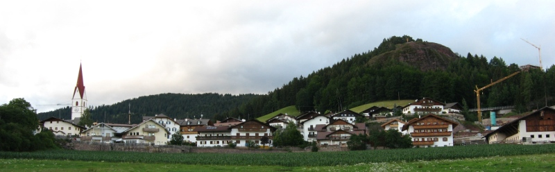
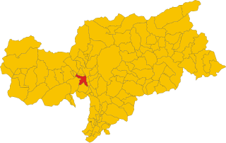
Посталь (Burgstall, South Tyrol, Postal)
.svg)
- коммуна в Италии
 Hiking in Посталь
Burgstall is a charming village located in South Tyrol, Italy, known for its picturesque landscapes and proximity to the Alps. Hiking around Burgstall offers a fantastic opportunity to explore the diverse terrain and enjoy stunning views.
Hiking Trails:
-
Local Trails: There are several well-marked hiking trails ranging from easy to moderate difficulty. These trails usually wind through lush meadows, forests, and offer scenic views of the surrounding valley and mountains.
-
Vilpian and the Tisens Area: Just a short distance from Burgstall, the trails in Vilpian and the nearby Tisens area provide opportunities for both relaxation and adventure. The area is known for its beautiful vineyards and panoramic views.
-
The Hirzer Mountain Range: For more seasoned hikers, trails leading to the Hirzer mountain range can be quite rewarding. The Hirzer cable car can assist with reaching higher altitudes if needed.
What to Expect:
- Scenic Views: Expect breathtaking views across the Merano region, with opportunities to spot landmarks and enjoy the natural beauty of the Alps.
- Wildlife and Flora: The region is rich in biodiversity, and you might come across various plant species as well as local wildlife.
- Cultural Sites: While hiking, take the chance to explore small chapels and traditional farms that contribute to the unique charm of the area.
Best Time to Hike:
- Spring and Fall: Spring (April to June) and Fall (September to October) offer mild temperatures and stunning color changes in the foliage.
- Summer: The summer months are popular for hiking, though it can be crowded on some of the more well-known trails. Early morning hikes are recommended to avoid the heat and crowds.
- Winter: Snowshoeing and winter hiking opportunities are available if you're interested in winter sports.
Tips:
- Stay Hydrated: Always carry enough water, especially on longer hikes.
- Trail Maps: Bring a map or download a hiking app to ensure you stay on the correct paths.
- Footwear: Wear sturdy hiking boots with good grip.
- Weather Preparedness: Be prepared for changing weather conditions, especially in mountainous areas.
Local Amenities:
- Accommodations: Burgstall has various lodging options ranging from family-run guesthouses to more luxurious stays.
- Food: Don’t miss the local cuisine — after a long hike, enjoy some South Tyrolean specialties at local restaurants.
Hiking in Burgstall is not just about the physical activity; it’s also about soaking in the serene environment and rich culture of South Tyrol. Enjoy your adventure!
- Страна:

- Почтовый код: 39014
- Телефонный код: 0473
- Код автомобильного номера: BZ
- Координаты: 46° 36' 34" N, 11° 11' 35" E


- GPS треки (wikiloc): [Ссылка]
- Высота над уровнем моря: 270 м m
- Площадь: 6.69 кв.км
- Население: 1887
- Веб сайт: http://www.gemeinde.burgstall.bz.it/de/default.asp
- Википедия русская: wiki(ru)
- Википедия английская: wiki(en)
- Википедия национальная: wiki(it)
- Хранилище Wikidata: Wikidata: Q474165
- Галерея изображений в википедии: [Ссылка]
- Катеория в википедии: [Ссылка]
- код Freebase: [/m/0g9j06]
- код GeoNames: Альт: [6535920]
- код VIAF: Альт: [593145858109523021979]
- ID отношения в OpenStreetMap: [47272]
- код GND: Альт: [7564298-0]
- UN/LOCODE: [ITPSL]
- код ISTAT: 021066
- кадастровый код Италии: G936
Граничит с регионами:


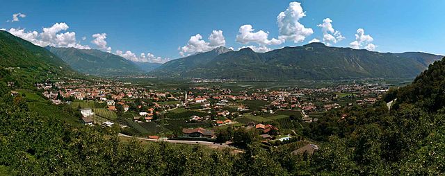
Мерано
- коммуна Италии
Hiking in Мерано
Merano, located in South Tyrol, Italy, is a stunning destination for hiking enthusiasts. Nestled in the mountains, it offers a beautiful combination of alpine scenery, Mediterranean climate, and rich cultural heritage. Here are some highlights about hiking in and around Merano:...
- Страна:
- Почтовый код: 39012
- Телефонный код: 0473
- Код автомобильного номера: BZ
- Координаты: 46° 40' 8" N, 11° 9' 50" E
- GPS треки (wikiloc): [Ссылка]
- Высота над уровнем моря: 325 м m
- Площадь: 26.34 кв.км
- Население: 40047
- Веб сайт: [Ссылка]

Верано
- коммуна в Италии
Hiking in Верано
Vöran, also known as Verano, is a picturesque village located in the South Tyrol region of northern Italy, nestled in the foothills of the Alps. It is a popular destination for hiking enthusiasts due to its stunning natural landscapes, diverse trails, and mild climate....
- Страна:
- Почтовый код: 39010
- Телефонный код: 0473
- Код автомобильного номера: BZ
- Координаты: 46° 36' 17" N, 11° 13' 35" E
- GPS треки (wikiloc): [Ссылка]
- Высота над уровнем моря: 1204 м m
- Площадь: 22.01 кв.км
- Население: 952
- Веб сайт: [Ссылка]


Гаргаццоне
- коммуна Италии
Hiking in Гаргаццоне
Gargazon, located in the South Tyrol region of northern Italy, is a wonderful area for hiking enthusiasts. The region is characterized by its stunning landscapes, which include lush forests, rolling hills, and picturesque views of the surrounding mountains, including the Dolomites. Here are some key points about hiking in Gargazon:...
- Страна:
- Почтовый код: 39010
- Телефонный код: 0473
- Код автомобильного номера: BZ
- Координаты: 46° 35' 4" N, 11° 12' 6" E
- GPS треки (wikiloc): [Ссылка]
- Высота над уровнем моря: 267 м m
- Площадь: 4.91 кв.км
- Население: 1688
- Веб сайт: [Ссылка]
Лана
- коммуна Италии
Hiking in Лана
Lana, located in South Tyrol, Italy, is a fantastic destination for hiking enthusiasts, offering a diverse range of trails set against stunning alpine scenery. Nestled near the larger town of Merano, Lana provides access to beautiful landscapes, charming villages, and cultural sites....
- Страна:
- Почтовый код: 39011
- Телефонный код: 0473
- Код автомобильного номера: BZ
- Координаты: 46° 37' 0" N, 11° 10' 0" E
- GPS треки (wikiloc): [Ссылка]
- Высота над уровнем моря: 310 м m
- Площадь: 36.12 кв.км
- Население: 12286
- Веб сайт: [Ссылка]


Мельтина
- коммуна Италии
Hiking in Мельтина
Mölten, or Molten, is a lovely village in South Tyrol, Italy, situated on the sunny side of the Adige Valley. It offers a variety of hiking trails that cater to different experience levels, making it an excellent destination for hikers....
- Страна:
- Почтовый код: 39010
- Телефонный код: 0471
- Код автомобильного номера: BZ
- Координаты: 46° 35' 15" N, 11° 15' 18" E
- GPS треки (wikiloc): [Ссылка]
- Высота над уровнем моря: 1140 м m
- Площадь: 36.95 кв.км
- Население: 1676
- Веб сайт: [Ссылка]