Бюсьер (Bussières, Haute-Saône, Bussières)

- коммуна во Франции, департамент Верхняя Сона
 Hiking in Бюсьер
Bussières, located in the Haute-Saône department in the Bourgogne-Franche-Comté region of France, offers a serene hiking experience that allows you to explore the natural beauty of rural France. While the region is less known than some of the larger national parks, it has its own charm, with varied landscapes including forests, hills, and rivers.
Key Features of Hiking in Bussières:
-
Scenic Trails: The area around Bussières has several marked hiking trails that range from easy walks suitable for families to more challenging routes for experienced hikers. The paths often pass through beautiful woodlands and farmland, offering a glimpse into the local flora and fauna.
-
Natural Beauty: The Haute-Saône region is characterized by rolling hills, meandering rivers, and rich forests, making it an ideal backdrop for outdoor activities. Look out for local wildlife, including birds and various plant species.
-
Cultural Heritage: Along your hikes, you may encounter traditional villages, historical landmarks, and local farms that provide insight into the culture of the region. This might include quaint churches, old stone buildings, and local markets.
-
Accessibility: Bussières is a small village, so it’s advisable to plan your routes ahead and ensure you have the necessary maps or GPS as some trails may not be well-marked. Local tourism offices or hiking clubs can provide guidance and updates on trails.
-
Seasonal Considerations: Each season brings its own allure to the hiking trails. Spring and summer are vibrant with wildflowers, while autumn offers a spectacular display of fall foliage. Winter hiking can be peaceful, though some trails may be less accessible due to snow.
Recommended Tips:
- Preparation: Always check the weather conditions before setting out, and dress in layers to accommodate changes in temperature.
- Hydration and Snacks: Carry plenty of water and some snacks to keep your energy up for longer hikes.
- Local Resources: Consider stopping by a local tourist information center to gather maps and suggestions for trails suitable for your hiking skills.
Whether you are a seasoned hiker or a casual walker looking to enjoy the beauty of nature, Bussières offers the perfect backdrop for a memorable hiking experience in France.
- Страна:

- Почтовый код: 70190
- Координаты: 47° 20' 15" N, 5° 58' 27" E


- GPS треки (wikiloc): [Ссылка]
- Площадь: 6.11 кв.км
- Население: 399
- Википедия русская: wiki(ru)
- Википедия английская: wiki(en)
- Википедия национальная: wiki(fr)
- Хранилище Wikidata: Wikidata: Q904722
- Катеория в википедии: [Ссылка]
- код Freebase: [/m/03nt7hb]
- код GeoNames: Альт: [6441847]
- номер SIREN: [217001072]
- код муниципалитета INSEE: 70107
Граничит с регионами:


Бу
- коммуна во Франции
- Страна:
- Почтовый код: 70190
- Координаты: 47° 22' 53" N, 6° 0' 6" E
- GPS треки (wikiloc): [Ссылка]
- Площадь: 14.62 кв.км
- Население: 600
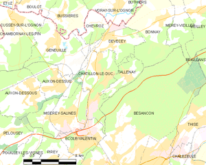
Châtillon-le-Duc
- коммуна во Франции
Hiking in Châtillon-le-Duc
Châtillon-le-Duc, located in the Doubs department of eastern France, offers a variety of hiking opportunities that cater to different skill levels and preferences. The area is characterized by its picturesque landscapes, including lush forests, rolling hills, and scenic valleys....
- Страна:
- Почтовый код: 25870
- Координаты: 47° 18' 15" N, 6° 0' 25" E
- GPS треки (wikiloc): [Ссылка]
- Площадь: 6.26 кв.км
- Население: 2040
- Веб сайт: [Ссылка]

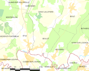
Було
- коммуна во Франции
- Страна:
- Почтовый код: 70190
- Координаты: 47° 20' 52" N, 5° 57' 36" E
- GPS треки (wikiloc): [Ссылка]
- Площадь: 7.08 кв.км
- Население: 670

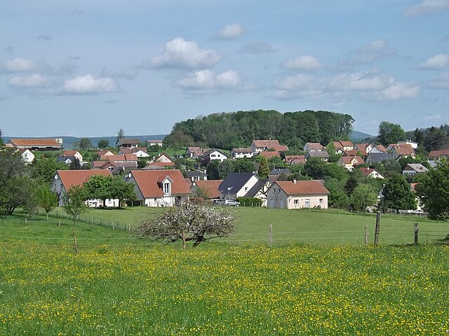
Chevroz
- коммуна во Франции
Hiking in Chevroz
Chevroz is a charming locality nestled in the heart of the Italian Alps, offering stunning landscapes and a variety of hiking opportunities for all experience levels. Here are some highlights about hiking in Chevroz:...
- Страна:
- Почтовый код: 25870
- Координаты: 47° 20' 0" N, 5° 59' 50" E
- GPS треки (wikiloc): [Ссылка]
- Площадь: 1.98 кв.км
- Население: 127


Cussey-sur-l'Ognon
- коммуна во Франции
Hiking in Cussey-sur-l'Ognon
Cussey-sur-l'Ognon is a charming commune located in the department of Doubs in the Bourgogne-Franche-Comté region of France. The area is known for its beautiful natural landscapes, making it a great destination for hiking enthusiasts....
- Страна:
- Почтовый код: 25870
- Координаты: 47° 20' 20" N, 5° 56' 17" E
- GPS треки (wikiloc): [Ссылка]
- Площадь: 7.55 кв.км
- Население: 1014
- Веб сайт: [Ссылка]


Воре-сюр-л’Оньон
- коммуна во Франции
Hiking in Воре-сюр-л’Оньон
Voray-sur-l'Ognon is a small commune located in the Doubs department in the Bourgogne-Franche-Comté region of eastern France. While not as widely known as some larger hiking destinations, it offers a charming experience for those who enjoy exploring the outdoors....
- Страна:
- Почтовый код: 70190
- Координаты: 47° 20' 20" N, 6° 1' 5" E
- GPS треки (wikiloc): [Ссылка]
- Высота над уровнем моря: 222 м m
- Площадь: 6.9 кв.км
- Население: 818

Geneuille
- коммуна во Франции
Hiking in Geneuille
Geneuille is a small commune located in the Doubs department of the Bourgogne-Franche-Comté region in eastern France. If you're considering hiking in or around Geneuille, you'll find a beautiful and diverse landscape that is characteristic of the region....
- Страна:
- Почтовый код: 25870
- Координаты: 47° 19' 25" N, 5° 58' 14" E
- GPS треки (wikiloc): [Ссылка]
- Площадь: 6.45 кв.км
- Население: 1347
- Веб сайт: [Ссылка]