By (By)

 Hiking in By
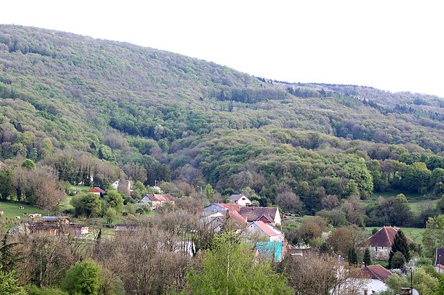
By, located in the Doubs department of France, is a charming destination for hiking enthusiasts. The region is known for its stunning natural landscapes, characterized by rolling hills, dense forests, and picturesque views of the surrounding countryside and rivers.
Hiking Trails
-
Sentier des Fontaines: This trail takes you through the lush countryside, where you can discover various natural springs, offering a refreshing backdrop for your hike.
-
Les Hauts de By: This trail provides panoramic views of the Doubs valley and is suitable for hikers of different skill levels.
-
Grands Sites de la Franche-Comté: You can connect to broader hiking networks in Franche-Comté, including marked routes that lead you through serene landscapes and historical sites.
Tips for Hiking in By, Doubs
-
Preparation: Always check the weather conditions before you head out. Packing layers and waterproof gear is advisable due to the possibility of sudden weather changes in mountainous areas.
-
Maps and Navigation: While many trails are marked, having a map or a hiking app can greatly assist in navigation, especially if you're exploring less traveled areas.
-
Local Wildlife: The Doubs region is home to diverse flora and fauna. Be respectful of wildlife by keeping a safe distance and not disturbing their habitat.
-
Cultural Sites: Consider combining your hike with visits to local historical sites, such as old mills or churches, to enrich your experience of the area’s culture.
-
Safety: Always inform someone about your hiking plans and estimated return time, and consider hiking with a companion for safety.
Hiking in By, Doubs offers a blend of natural beauty and cultural exploration, making it a rewarding experience for any outdoor enthusiast. Enjoy your hike!
- Страна:

- Почтовый код: 25440
- Координаты: 47° 0' 47" N, 5° 53' 22" E


- GPS треки (wikiloc): [Ссылка]
- Площадь: 7.34 кв.км
- Население: 65
- Википедия английская: wiki(en)
- Википедия национальная: wiki(fr)
- Хранилище Wikidata: Wikidata: Q838748
- Катеория в википедии: [Ссылка]
- код Freebase: [/m/03h3vlp]
- код Freebase: [/m/03h3vlp]
- код GeoNames: Альт: [3029330]
- код GeoNames: Альт: [3029330]
- номер SIREN: [212501043]
- номер SIREN: [212501043]
- код BNF: [15252330g]
- код BNF: [15252330g]
- код VIAF: Альт: [306440633]
- код VIAF: Альт: [306440633]
- код муниципалитета INSEE: 25104
- код муниципалитета INSEE: 25104
Граничит с регионами:

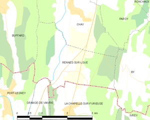
Rennes-sur-Loue
- коммуна во Франции
Hiking in Rennes-sur-Loue
Rennes-sur-Loue is a picturesque village located in the Jura region of France, known for its stunning natural landscapes, hiking trails, and the scenic Loue River. Here are some key points to consider when hiking in and around Rennes-sur-Loue:...
- Страна:
- Почтовый код: 25440
- Координаты: 47° 0' 44" N, 5° 51' 10" E
- GPS треки (wikiloc): [Ссылка]
- Площадь: 5.5 кв.км
- Население: 95


La Chapelle-sur-Furieuse
- коммуна во Франции
Hiking in La Chapelle-sur-Furieuse
La Chapelle-sur-Furieuse is a picturesque village situated in the Doubs department of France, nestled in the Jura Mountains. It’s a great location for hiking enthusiasts looking to explore the beautiful natural landscapes of this region. Here’s what you can expect when hiking around La Chapelle-sur-Furieuse:...
- Страна:
- Почтовый код: 39110
- Координаты: 46° 59' 52" N, 5° 51' 27" E
- GPS треки (wikiloc): [Ссылка]
- Площадь: 9.03 кв.км
- Население: 322


Ивре
- коммуна во Франции
Hiking in Ивре
It seems like there might be a little confusion with the name "Ivrey." If you're referring to hiking in a specific region or trail, I would need a bit more information to provide accurate guidance....
- Страна:
- Почтовый код: 39110
- Координаты: 46° 59' 25" N, 5° 53' 39" E
- GPS треки (wikiloc): [Ссылка]
- Площадь: 6.67 кв.км
- Население: 64

Ronchaux
- коммуна во Франции
Hiking in Ronchaux
Ronchaux is a picturesque area located in the Jura Mountains of Switzerland. It offers stunning landscapes, beautiful forests, and a variety of hiking trails suitable for different skill levels....
- Страна:
- Почтовый код: 25440
- Координаты: 47° 3' 8" N, 5° 53' 55" E
- GPS треки (wikiloc): [Ссылка]
- Площадь: 5.24 кв.км
- Население: 90


Paroy
Hiking in Paroy
Paroy, located in the Doubs department in the Bourgogne-Franche-Comté region of France, offers a variety of outdoor hiking experiences that showcase the natural beauty of the area. The landscape primarily features rolling hills, forests, rivers, and serene countryside, making it a great destination for both casual walkers and experienced hikers....
- Страна:
- Почтовый код: 25440
- Координаты: 47° 2' 35" N, 5° 52' 54" E
- GPS треки (wikiloc): [Ссылка]
- Площадь: 4.37 кв.км
- Население: 124